Difference between revisions of "2017-06-22 52 1"
imported>Sourcerer m (→New expedition) |
imported>FippeBot m (Location) |
||
| Line 46: | Line 46: | ||
[[Category:Expeditions with photos]] | [[Category:Expeditions with photos]] | ||
[[Category:Coordinates reached]] | [[Category:Coordinates reached]] | ||
| + | {{location|GB|ENG|SFK}} | ||
Latest revision as of 02:40, 16 August 2019
| Thu 22 Jun 2017 in Norwich, UK: 52.5072053, 1.7352907 geohashing.info google osm bing/os kml crox |
Location
Lowestoft and Yarmouth Rugby Union Football Club, Suffolk, UK.
Participants
Plans
Go after a 5.5 mile walk with the Wensum Ramblers a few miles south west of the hashpoint.
Expedition
Thunder was rumbling but there was no rainfall. The club site looked deserted. The playing fields could be reached through a gate and it was easy to zero the distance.
There has been a run of unlucky locations in 52, 1. Many points have landed in the sea or estuaries. Others have landed inside industrial zones. In addition, Sourcerer (Neil) has, for over a year now, a new hobby walking with local ramblers groups. These walks tend to be longer than geohash treks making them better for the fight against fat and laziness, my preferred state!
Photos
- Gallery
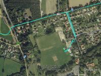
Google Earth Track
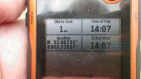
Proof
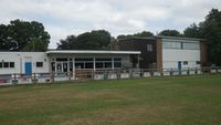
The Club House
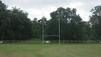
The Pitch


Achievements
Expeditions and Plans
| 2017-06-22 | ||
|---|---|---|
| Norwich, United Kingdom | Sourcerer | Lowestoft and Yarmouth Rugby Union Football Club, Suffolk, UK. |
| Pyhäjärvi, Finland | Pastori, The Wife | Savukoski, Pyörreseljänmännikkö, between Värriö and Tanhua. The point lies ... |
Sourcerer's Expedition Links
2017-05-21 52 0 - 2017-06-22 52 1 - 2017-06-24 52 1 - KML file download of Sourcerer's expeditions for use with Google Earth.