Difference between revisions of "2017-07-20 52 1"
imported>Sourcerer (An expedition message sent via Geohash Droid for Android.) |
imported>FippeBot m (Location) |
||
| (3 intermediate revisions by one other user not shown) | |||
| Line 1: | Line 1: | ||
| − | + | {{meetup graticule | |
| − | |||
| − | |||
| − | |||
| − | |||
| − | |||
| − | |||
| − | |||
| − | |||
| − | |||
| − | {{meetup graticule | ||
| lat=52 | | lat=52 | ||
| lon=1 | | lon=1 | ||
| date=2017-07-20 | | date=2017-07-20 | ||
| + | | graticule_name=Norwich, UK | ||
| + | | graticule_link=Norwich, United Kingdom | ||
}} | }} | ||
| − | |||
| − | |||
__NOTOC__ | __NOTOC__ | ||
| + | == Location == | ||
| − | + | A field perimeter at Old Hall Farm, St Nicholas South Elmham, Suffolk, UK. | |
| − | |||
== Participants == | == Participants == | ||
| − | + | ||
| − | + | [[User:Sourcerer|Sourcerer]] | |
== Plans == | == Plans == | ||
| − | + | ||
| + | Go after walking with the Wensum Ramblers. The point is close to the walk. | ||
== Expedition == | == Expedition == | ||
| − | |||
| − | + | After an 8km walk with the Wensum Ramblers, this point was close by. The expedition was delayed a few minutes by a torrential rain shower. Then it was an easy walk along a public footpath and farm access road. At the field entrance there was a bit of ambiguity whether the footpath stayed on the farm access road or followed the field perimeter so I tried the perimeter. This led to the zero mark, right at the edge of a wet looking ripe wheat crop. All very easy if damp. There were four retro points nearby. | |
| − | |||
| − | == Photos == | + | == Photos == |
| − | < | + | <gallery caption="Gallery" widths="200px" heights="200px" perrow="3"> |
| − | Image: | + | Image:2017-07-20_52_1_Sourcerer_1500553076649.jpg | Arrived. [http://www.openstreetmap.org/?lat=52.39478588&lon=1.40306890&zoom=16&layers=B000FTF @52.3948,1.4031] |
| − | -- | + | Image:2017-07-20 52 1 Sourcerer.jpg | Google Earth Track |
| − | |||
</gallery> | </gallery> | ||
== Achievements == | == Achievements == | ||
{{#vardefine:ribbonwidth|800px}} | {{#vardefine:ribbonwidth|800px}} | ||
| − | |||
| − | + | {{Sourcerer_links | |
| − | + | | prev = 2017-07-16 52 0 | |
| − | + | | curr = 2017-07-20 52 1 | |
| − | + | | next = 2017-07-31 52 1 | |
| − | + | | date = 2017-07-20 | |
| − | + | }} | |
| − | |||
| − | |||
| − | |||
| − | -- | ||
| − | |||
| − | |||
| − | |||
[[Category:Expeditions]] | [[Category:Expeditions]] | ||
| − | |||
[[Category:Expeditions with photos]] | [[Category:Expeditions with photos]] | ||
| − | |||
| − | |||
| − | |||
| − | |||
| − | |||
[[Category:Coordinates reached]] | [[Category:Coordinates reached]] | ||
| − | + | {{location|GB|ENG|SFK}} | |
| − | |||
| − | |||
| − | |||
| − | |||
| − | |||
| − | |||
| − | |||
| − | |||
| − | |||
| − | |||
| − | |||
| − | |||
| − | |||
| − | |||
| − | |||
| − | |||
| − | |||
Latest revision as of 02:46, 16 August 2019
| Thu 20 Jul 2017 in Norwich, UK: 52.3947200, 1.4029836 geohashing.info google osm bing/os kml crox |
Location
A field perimeter at Old Hall Farm, St Nicholas South Elmham, Suffolk, UK.
Participants
Plans
Go after walking with the Wensum Ramblers. The point is close to the walk.
Expedition
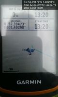
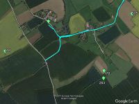
After an 8km walk with the Wensum Ramblers, this point was close by. The expedition was delayed a few minutes by a torrential rain shower. Then it was an easy walk along a public footpath and farm access road. At the field entrance there was a bit of ambiguity whether the footpath stayed on the farm access road or followed the field perimeter so I tried the perimeter. This led to the zero mark, right at the edge of a wet looking ripe wheat crop. All very easy if damp. There were four retro points nearby.
Photos
- Gallery
Arrived. @52.3948,1.4031
Achievements
Expeditions and Plans
| 2017-07-20 | ||
|---|---|---|
| Kassel, Germany | GeorgDerReisende | The hash lay on a meadow near Calden. |
| Norwich, United Kingdom | Sourcerer | A field perimeter at Old Hall Farm, St Nicholas South Elmham, Suffolk, UK. |
Sourcerer's Expedition Links
2017-07-16 52 0 - 2017-07-20 52 1 - 2017-07-31 52 1 - KML file download of Sourcerer's expeditions for use with Google Earth.

