Difference between revisions of "2019-02-13 51 0"
imported>Sourcerer m (→New expedition) |
imported>FippeBot m (Location) |
||
| (7 intermediate revisions by one other user not shown) | |||
| Line 9: | Line 9: | ||
== Location == | == Location == | ||
| − | 1.4 km north of Great Bardfield, Esset, UK. | + | Somewhere on a 3300 km path over 52 graticules. Success 1.4 km north of Great Bardfield, Esset, UK. |
== Planning == | == Planning == | ||
| Line 21: | Line 21: | ||
== Expedition == | == Expedition == | ||
| + | Get up at 02:30 Cyprus time. With the hand-held satnav programmed, get a taxi to Paphos Airport at 03:40. Take of on FR3132 to Stansted at about 06:10. Watch the satnav and re-program it for each graticule. This passes the 4.5 hour flight time quite nicely. There were three close approaches at: | ||
| + | |||
| + | * 37, 27 - 2.0 km | ||
| + | * 41, 23 - 3.1 km | ||
| + | * 47, 14 - 2.7 km | ||
| + | |||
| + | For an "air" geohash, you need to be within 310 metres of the hashpoint. These three graticules were the closest. | ||
| + | |||
| + | Close to Stansted airport, I passed 4.3 km NW of the hashpoint with these details from the tracklog ... | ||
| + | |||
| + | 2019-02-13 09:05:52-837 | ||
| + | |||
| + | Longitude: 0.389309 | ||
| + | Latitude: 51.987543 | ||
| + | Altitude: 2629.265 ft | ||
| + | Speed: 172.5 mph | ||
| + | Heading: 223.8 | ||
| + | Time: 2019-02-13T08:56:24Z | ||
| + | |||
| + | This point was close to the airport AND close to my usual route home. After five weeks of mountain walking with no driving, I prefer to drive slowly for the first few miles to get back into the habits and reflexes for safety so it was a no brainer. Go via this hashpoint. | ||
| + | |||
| + | Stansted airport long stay parking tried to make me pay £770 for pre-booked, pre-paid parking. No human help was available and it took a long time to locate the "Assist" button to get help. Eventually my story was believed and I got out of the car park. I wonder how many tired people just pay extra to get out and get home. | ||
| + | |||
| + | After a short drive and a 2.9 km round trip on foot, I reached the hashpoint close to a field perimeter, close to a public footpath. | ||
| + | |||
| + | Success after a 13 hour, 52 graticule, 3500 km expedition! | ||
== Photos == | == Photos == | ||
<gallery caption="Gallery" widths="200px" heights="200px" perrow="3"> | <gallery caption="Gallery" widths="200px" heights="200px" perrow="3"> | ||
Image:2019-02-13_51_0_Sourcerer_1550057033133.jpg | Arrived. [http://www.openstreetmap.org/?lat=51.96060598&lon=.43540299&zoom=16&layers=B000FTF @51.9606,.4354] | Image:2019-02-13_51_0_Sourcerer_1550057033133.jpg | Arrived. [http://www.openstreetmap.org/?lat=51.96060598&lon=.43540299&zoom=16&layers=B000FTF @51.9606,.4354] | ||
| + | Image:2019-02-13 51 0 Sourcerer 50 Graticules.jpg | Google Earth View of 52 graticules | ||
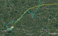
| + | Image:2019-02-13 51 0 Sourcerer.jpg | Google Earth View of 51, 0 | ||
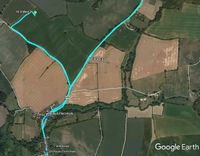
| + | Image:2019-02-13 51 0 Sourcerer On Foot.jpg | On Foot to the Hashpoint | ||
| + | Image:2019-02-13 51 0 Sourcerer Scrn.jpg | Three Screen Grabs | ||
</gallery> | </gallery> | ||
| Line 32: | Line 62: | ||
| prev = 2019-01-09 49 8 | | prev = 2019-01-09 49 8 | ||
| curr = 2019-02-13_51_0 | | curr = 2019-02-13_51_0 | ||
| − | | next = 2019- | + | | next = 2019-05-21_52_0 |
| − | | date = 2019-02- | + | | date = 2019-02-13 |
}} | }} | ||
| Line 39: | Line 69: | ||
[[Category:Expeditions with photos]] | [[Category:Expeditions with photos]] | ||
[[Category:Coordinates reached]] | [[Category:Coordinates reached]] | ||
| + | {{location|GB|ENG|ESS}} | ||
Latest revision as of 03:32, 7 August 2019
| Wed 13 Feb 2019 in London East: 51.9606014, 0.4354559 geohashing.info google osm bing/os kml crox |
Location
Somewhere on a 3300 km path over 52 graticules. Success 1.4 km north of Great Bardfield, Esset, UK.
Planning
Visit 52 graticules. Hope to hit a hashpoint.
Participants
Expedition
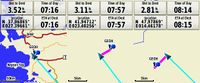
Get up at 02:30 Cyprus time. With the hand-held satnav programmed, get a taxi to Paphos Airport at 03:40. Take of on FR3132 to Stansted at about 06:10. Watch the satnav and re-program it for each graticule. This passes the 4.5 hour flight time quite nicely. There were three close approaches at:
- 37, 27 - 2.0 km
- 41, 23 - 3.1 km
- 47, 14 - 2.7 km
For an "air" geohash, you need to be within 310 metres of the hashpoint. These three graticules were the closest.
Close to Stansted airport, I passed 4.3 km NW of the hashpoint with these details from the tracklog ...
2019-02-13 09:05:52-837

Longitude: 0.389309
Latitude: 51.987543
Altitude: 2629.265 ft
Speed: 172.5 mph
Heading: 223.8
Time: 2019-02-13T08:56:24Z
This point was close to the airport AND close to my usual route home. After five weeks of mountain walking with no driving, I prefer to drive slowly for the first few miles to get back into the habits and reflexes for safety so it was a no brainer. Go via this hashpoint.
Stansted airport long stay parking tried to make me pay £770 for pre-booked, pre-paid parking. No human help was available and it took a long time to locate the "Assist" button to get help. Eventually my story was believed and I got out of the car park. I wonder how many tired people just pay extra to get out and get home.
After a short drive and a 2.9 km round trip on foot, I reached the hashpoint close to a field perimeter, close to a public footpath.
Success after a 13 hour, 52 graticule, 3500 km expedition!
Photos
- Gallery
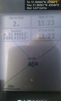
Arrived. @51.9606,.4354
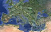
Google Earth View of 52 graticules
Google Earth View of 51, 0
On Foot to the Hashpoint
Three Screen Grabs


Achievements
Expeditions and Plans
| 2019-02-13 | ||
|---|---|---|
| Providence, Rhode Island | User:Azsr | Off of Maple Valley Road in Coventry, near the George Parker Woodland manag... |
| London East, United Kingdom | Sourcerer | Somewhere on a 3300 km path over 52 graticules. Success 1.4 km north of Gre... |
Sourcerer's Expedition Links
2019-01-09 49 8 - 2019-02-13_51_0 - 2019-05-21_52_0 - KML file download of Sourcerer's expeditions for use with Google Earth.