Difference between revisions of "Tooele, Utah"
From Geohashing
imported>Xaco |
(added W1THRD's expedition for today) |
||
| (25 intermediate revisions by 13 users not shown) | |||
| Line 1: | Line 1: | ||
{{graticule | {{graticule | ||
| − | | | + | | lat= 40 |
| − | |nw | + | | lon= -112 |
| − | |n | + | | nw = [[Park Valley, Utah|Park Valley]] |
| − | |ne | + | | n = [[Clearfield, Utah|Clearfield]] |
| − | |w | + | | ne = [[Ogden, Utah|Ogden]] |
| − | |e | + | | w = [[Bonneville Salt Flats, Utah|Bonneville Salt Flats]] |
| − | |sw | + | | name = [[Tooele, Utah|Tooele]] |
| − | |s | + | | e = [[Salt Lake City, Utah|Salt Lake City]] |
| − | |se | + | | sw = [[Fish Springs, Utah|Fish Springs]] |
| + | | s = [[Delta, Utah|Delta]] | ||
| + | | se = [[Nephi, Utah|Nephi]] | ||
}} | }} | ||
| − | The Tooele, Utah [[graticule]] is at | + | The Tooele, Utah [[graticule]] is at {{Today's location|lat=40|lon=-112|text=latitude 40, longitude -112}}. |
== Activities == | == Activities == | ||
== Notable Events == | == Notable Events == | ||
| + | *[[2024-09-23 40 -112]] [[User:W1THRD|W1THRD]] Out in a natural area, at the dead end of Solstice View Drive, in Coppeton, Utah | ||
| + | *[[2020-08-22 40 -112]] [[User:Mckaysalisbury|McKay]] ([[User talk:Mckaysalisbury|talk]]) 10 year hiatus! In an undeveloped lot in West Valley City. | ||
| + | *[[2010-05-29 40 -112]] [[User: Mabeuf|Mabeuf]] and [[User: ajc13|Ajc13]] on separate trips. In the desert by Five Mile Pass. | ||
| + | *[[2010-05-27 40 -112]] [[User: Mabeuf|Mabeuf]] lives next door, so he thought he'd take a trip to Vernon. | ||
| + | *[[2009-11-11 40 -112]] [[User:Geohashgirl|Geohashgirl]] did NOT make it to the hash on [[2009-11-11]] because of Camp Williams. | ||
| + | *[[2009-09-01 40 -112]] [[User:GarafaJon|GarafaJon]] attempted to reach the hash, but was unable to get across the lake to Antelope Island. | ||
| + | *[[2008-07-09 40 -112]] [[User:xaco|xaco]] made it to the hash near Copper Hills High School. | ||
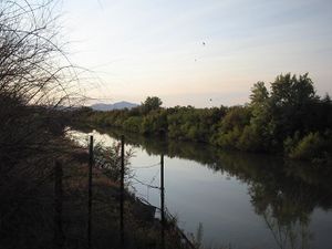
*[[2008-06-14]] [[User:Robyn|Robyn]] got within a mile of the hash, in a small lake north west of the airport, but a wide ditch named Goggin Drain barred the way. [[Image:2008-06-14_40_-112.JPG|thumb|Goggin Drain]] | *[[2008-06-14]] [[User:Robyn|Robyn]] got within a mile of the hash, in a small lake north west of the airport, but a wide ditch named Goggin Drain barred the way. [[Image:2008-06-14_40_-112.JPG|thumb|Goggin Drain]] | ||
| − | |||
| + | == Local Geohashers == | ||
| − | + | * [[User:xaco|xaco]]'s brother lives in this graticule, so he occasionally ends up around here. | |
| + | * [[User:DreadWolf|DreadWolf]] | ||
| + | * [[User:Foxrabbit|Foxrabbit]] | ||
| + | * [[User:W1THRD|W1THRD]] | ||
| + | * ''See also the [[Salt Lake City, Utah]] graticule'' | ||
| − | + | == Achievements == | |
| + | {{Graticule unlocked|date=2008-07-09|latitude=40|longitude=-112|name=[[User:xaco|xaco]]}} | ||
[[Category:Utah]] | [[Category:Utah]] | ||
| − | [[Category:Active | + | [[Category:Active graticules]] |
Latest revision as of 23:44, 23 September 2024
| Park Valley | Clearfield | Ogden |
| Bonneville Salt Flats | Tooele | Salt Lake City |
| Fish Springs | Delta | Nephi |
|
Today's location: geohashing.info google osm bing/os kml crox | ||
The Tooele, Utah graticule is at latitude 40, longitude -112.
Activities
Notable Events
- 2024-09-23 40 -112 W1THRD Out in a natural area, at the dead end of Solstice View Drive, in Coppeton, Utah
- 2020-08-22 40 -112 McKay (talk) 10 year hiatus! In an undeveloped lot in West Valley City.
- 2010-05-29 40 -112 Mabeuf and Ajc13 on separate trips. In the desert by Five Mile Pass.
- 2010-05-27 40 -112 Mabeuf lives next door, so he thought he'd take a trip to Vernon.
- 2009-11-11 40 -112 Geohashgirl did NOT make it to the hash on 2009-11-11 because of Camp Williams.
- 2009-09-01 40 -112 GarafaJon attempted to reach the hash, but was unable to get across the lake to Antelope Island.
- 2008-07-09 40 -112 xaco made it to the hash near Copper Hills High School.
- 2008-06-14 Robyn got within a mile of the hash, in a small lake north west of the airport, but a wide ditch named Goggin Drain barred the way.
Local Geohashers
- xaco's brother lives in this graticule, so he occasionally ends up around here.
- DreadWolf
- Foxrabbit
- W1THRD
- See also the Salt Lake City, Utah graticule
Achievements
xaco earned the Graticule Unlocked Achievement
|
