Difference between revisions of "2020-09-10 35 -105"
m (did substitution not work?) |
m (subst-ing) |
||
| (13 intermediate revisions by 3 users not shown) | |||
| Line 1: | Line 1: | ||
| − | {{ | + | <!-- If you did not specify these parameters in the template, please substitute appropriate values for IMAGE, LAT, LON, and DATE (YYYY-MM-DD format) |
| − | + | ||
| − | | | + | [[Image:{{{image|IMAGE}}}|thumb|left]] |
| − | | | + | |
| − | | | + | Remove this section if you don't want an image at the top (left) of your report. You should remove the "Image:" or "File:" |
| − | + | tag from your image file name, and replace the all upper-case word IMAGE in the above line. | |
| − | + | ||
| − | + | And DON'T FORGET to add your expedition and the best photo you took to the gallery on the Main Page! We'd love to read your report, but that means we first have to discover it! :) | |
| − | + | -->{{meetup graticule | |
| − | + | | lat=35 | |
| − | + | | lon=-105 | |
| − | + | | date=2020-09-10 | |
| − | | | + | }}<!-- edit as necessary --> |
| − | | | + | |
| − | | | + | == Location == |
| − | | | + | single-track by intermittent stream just to the west of southern Eldorado |
| + | |||
| + | == Participants == | ||
| + | [[user:Arlo]] | ||
| + | |||
| + | == Plans == | ||
| + | Drive to the pullover at the end of Avenida Eldorado, walk from there with boots to guard against mud. | ||
| + | |||
| + | == Expedition == | ||
| + | Close, but no cigar. A no-trespassing sign stopped me not far from the hash. But I was able to follow some nice cow trails there, it wasn't too muddy, I got some [[geotrashing]] done, and a [[raptor|hawk]] screamed at me, so it was a good walk. | ||
| + | |||
| + | == Tracklog == | ||
| + | {{tracklog|2020-09-10 35 -105.gpx}} | ||
| + | |||
| + | aka [[osmuser:Arlo\%20James\%20Barnes/traces/3406987]] | ||
| + | |||
| + | == Photos == | ||
| + | <gallery perrow="5"> | ||
| + | 2020-09-10 35 -105 trash.jpg|The trash cache. This is all from the area I parked at. | ||
| + | 2020-09-10 35 -105 path.jpg|The way north ended up being on top of a berm for some reason (edit: I think it is the remains of an abandoned railroad grade, it joins the current rail line at Kennedy). Here it is cut to allow an intermittent stream (currently 'dry' meaning not flowing, although still moist from a recent rain) through. | ||
| + | 2020-09-10 35 -105 sign 1.jpg|The first no-trespassing sign I encountered, whereupon I turned left (westward). | ||
| + | 2020-09-10 35 -105 sign 2.jpg|Despite walking along the fence for some ways, it did not let up before the point at which I would have to continue north. Here is the second no-trespassing sign near there. Pat Lyons is no longer the land commissioner (not surprising that signs out in the scrub don't get updated) and this area was free of trash, unlike the parking area earlier. | ||
| + | 2020-09-10 35 -105 tree.jpg|Where hobbits would hide from nazghul. In the far ground is an aerostat-style windmill, and the fence with the second no-trespassing sign on it. | ||
| + | 2020-09-10 35 -105 dramatic reenactment.png|A recreation of how I was shouted farther down the trail by a redtail. Picture quality suffered from the distance I was putting between myself and it, so my artistic impression will have to suffice. | ||
| + | </gallery> | ||
| + | |||
| + | == Achievements == | ||
| + | {{#vardefine:ribbonwidth|800px}} | ||
| + | |||
| + | {{geotrash | ||
| + | |latitude=35 | ||
| + | |longitude=-105 | ||
| + | |date=2020-09-10 | ||
| + | |name=[[user:Arlo]] | ||
| + | |image=2020-09-10 35 -105 trash.jpg | ||
}} | }} | ||
| + | {{no trespassing | ||
| + | |latitude=35 | ||
| + | |longitude=-105 | ||
| + | |date=2020-09-10 | ||
| + | |name=[[user:Arlo]] | ||
| + | |image=2020-09-10 35 -105 sign 1.jpg | ||
| + | |distance=within 458 metres of the hash | ||
| + | }} | ||
| + | |||
| + | [[category:expeditions]] | ||
| + | [[category:expeditions with photos]] | ||
| + | [[Category:Coordinates not reached]] | ||
| + | [[category:not reached - No public access]] | ||
| + | {{location|US|NM|ST}} | ||
Latest revision as of 20:21, 24 May 2024
| Thu 10 Sep 2020 in 35,-105: 35.5244520, -105.9921970 geohashing.info google osm bing/os kml crox |
Location
single-track by intermittent stream just to the west of southern Eldorado
Participants
Plans
Drive to the pullover at the end of Avenida Eldorado, walk from there with boots to guard against mud.
Expedition
Close, but no cigar. A no-trespassing sign stopped me not far from the hash. But I was able to follow some nice cow trails there, it wasn't too muddy, I got some geotrashing done, and a hawk screamed at me, so it was a good walk.
Tracklog
aka osmuser:Arlo\ James\ Barnes/traces/3406987
Photos
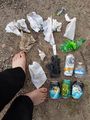
The trash cache. This is all from the area I parked at.
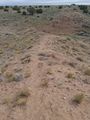
The way north ended up being on top of a berm for some reason (edit: I think it is the remains of an abandoned railroad grade, it joins the current rail line at Kennedy). Here it is cut to allow an intermittent stream (currently 'dry' meaning not flowing, although still moist from a recent rain) through.
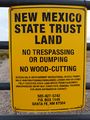
The first no-trespassing sign I encountered, whereupon I turned left (westward).
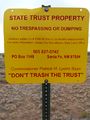
Despite walking along the fence for some ways, it did not let up before the point at which I would have to continue north. Here is the second no-trespassing sign near there. Pat Lyons is no longer the land commissioner (not surprising that signs out in the scrub don't get updated) and this area was free of trash, unlike the parking area earlier.
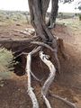
Where hobbits would hide from nazghul. In the far ground is an aerostat-style windmill, and the fence with the second no-trespassing sign on it.
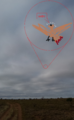
A recreation of how I was shouted farther down the trail by a redtail. Picture quality suffered from the distance I was putting between myself and it, so my artistic impression will have to suffice.


Achievements
user:Arlo earned the GeoTrash Geohash Achievement
|
user:Arlo earned the No trespassing consolation prize
|