Difference between revisions of "2020-11-01 46 7"
([live] Reached it together with a friend!) |
m (Location) |
||
| (4 intermediate revisions by one other user not shown) | |||
| Line 1: | Line 1: | ||
| − | + | {{meetup graticule | |
| − | |||
| − | |||
| − | |||
| − | |||
| − | |||
| − | |||
| − | |||
| − | |||
| lat=46 | | lat=46 | ||
| lon=7 | | lon=7 | ||
| date=2020-11-01 | | date=2020-11-01 | ||
| − | }} | + | }} |
__NOTOC__ | __NOTOC__ | ||
== Location == | == Location == | ||
| − | + | In a forest near Innerberg, Canton Bern, Switzerland, Earth. | |
== Participants == | == Participants == | ||
| − | + | * [[User:Tungmar|Tungmar]] ([[User talk:Tungmar|talk]]) | |
| − | + | * Tungmar's Friend | |
== Plans == | == Plans == | ||
| − | + | Go by bus from Bern to Innersberg. Then it is a short walk. | |
== Expedition == | == Expedition == | ||
| − | + | [[User:Tungmar|Tungmar]] ([[User talk:Tungmar|talk]]) saw the hash on the map and he guess that the location could be accessible - making it the third consecutive hash for him (with out going home). The public transport from Neuenburg was not great. The fastest way was to go to Bern, wait a hour and then do a 30 minutes bus ride. At first this looked like an anointing and time wasting route to him. But it turned out to be the perfect timing for Tungmar's friend to join the adventure! Excited he waited the hour and the meetup was joyful. | |
| + | |||
| + | Soon the two found themselves in the forest with the hash. The coordinate pointed town a steep slope. The first attempt straight to the point lead into thick undergrowth so they needed to backtrack and take an other way down. Deeper town they followed the coordinate and found them on a dirt track. Easy! Pictures taken, they followed the track a few meter to the end, turned and found that it lead back to the bus stop. | ||
| + | Some argument startet over which map is better: Swisstopo or OpenStreetMap. In the end, neither of them had the track with the hash mapped (but OSM soon will have it :-P). | ||
| − | |||
== Tracklog == | == Tracklog == | ||
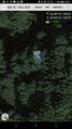
| − | + | [[File:2020-11-01 46 7 Track.jpeg|400px]] | |
== Photos == | == Photos == | ||
| − | |||
| − | |||
| − | |||
<gallery perrow="5"> | <gallery perrow="5"> | ||
| + | Image:2020-11-01 46 7 No easy pass.jpeg | No easy peasy passing | ||
| + | Image:2020-11-01 46 7 Reached.jpeg | The app gave green lights | ||
| + | Image:2020-11-01 46 7 Feets at hash.jpeg | Feets together at the hash | ||
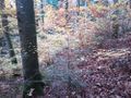
| + | Image:2020-11-01 46 7 Woobely Picture of View.jpeg | A very well taken picture of the woody surrounding of the hash. | ||
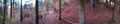
| + | Image:2020-11-01 46 7 View near the bus stop.jpeg | From the bus stop was actually a nice view to some mountains | ||
</gallery> | </gallery> | ||
== Achievements == | == Achievements == | ||
{{#vardefine:ribbonwidth|800px}} | {{#vardefine:ribbonwidth|800px}} | ||
| − | + | {{Land geohash | latitude=46 | longitude=7 | date=2020-11-01 | name=Tungmar's Friend}} | |
| − | + | {{Public transport geohash | latitude=46 | longitude=7 | date=2020-11-01 | name=Tungmar's Friend}} | |
| − | + | {{drag-along | latitude=46 | longitude=7 | date=2020-11-01 | partner = a friend | name=[[User:Tungmar|Tungmar]] | image=2020-11-01 46 7 Feets at hash.jpeg}} | |
| − | + | {{consecutive geohash | count=3 | latitude=46 | longitude=7 | date=2020-10-30 | name=[[User:Tungmar|Tungmar]]}} | |
| − | [[ | ||
| − | |||
| − | |||
| − | |||
| − | |||
| − | |||
| − | [[ | ||
| − | |||
| − | |||
| − | |||
| − | |||
[[Category:Expeditions]] | [[Category:Expeditions]] | ||
| − | |||
[[Category:Expeditions with photos]] | [[Category:Expeditions with photos]] | ||
| − | |||
| − | |||
| − | |||
| − | |||
| − | |||
[[Category:Coordinates reached]] | [[Category:Coordinates reached]] | ||
| − | + | {{location|CH|BE}} | |
| − | |||
| − | |||
| − | |||
| − | |||
| − | |||
| − | |||
| − | |||
| − | |||
| − | |||
| − | |||
| − | |||
| − | |||
| − | |||
| − | |||
| − | |||
| − | |||
| − | |||
Latest revision as of 20:42, 3 November 2020
| Sun 1 Nov 2020 in 46,7: 46.9914429, 7.3033575 geohashing.info google osm bing/os kml crox |
Location
In a forest near Innerberg, Canton Bern, Switzerland, Earth.
Participants
Plans
Go by bus from Bern to Innersberg. Then it is a short walk.
Expedition
Tungmar (talk) saw the hash on the map and he guess that the location could be accessible - making it the third consecutive hash for him (with out going home). The public transport from Neuenburg was not great. The fastest way was to go to Bern, wait a hour and then do a 30 minutes bus ride. At first this looked like an anointing and time wasting route to him. But it turned out to be the perfect timing for Tungmar's friend to join the adventure! Excited he waited the hour and the meetup was joyful.
Soon the two found themselves in the forest with the hash. The coordinate pointed town a steep slope. The first attempt straight to the point lead into thick undergrowth so they needed to backtrack and take an other way down. Deeper town they followed the coordinate and found them on a dirt track. Easy! Pictures taken, they followed the track a few meter to the end, turned and found that it lead back to the bus stop.
Some argument startet over which map is better: Swisstopo or OpenStreetMap. In the end, neither of them had the track with the hash mapped (but OSM soon will have it :-P).
Tracklog

Photos
No easy peasy passing
The app gave green lights
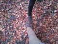
Feets together at the hash
A very well taken picture of the woody surrounding of the hash.
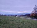
From the bus stop was actually a nice view to some mountains


Achievements
Tungmar's Friend earned the Land geohash achievement
|
Tungmar's Friend earned the Public transport geohash achievement
|
Tungmar earned the Drag-along achievement
|
Tungmar earned the Consecutive geohash achievement
|