Difference between revisions of "2021-04-02 56 14"
(Documented expedition) |
m (subst-ing) |
||
| (One intermediate revision by the same user not shown) | |||
| Line 1: | Line 1: | ||
{{meetup graticule | {{meetup graticule | ||
| − | | lat= | + | | lat=56 |
| − | | lon= | + | | lon=14 |
| − | | date= | + | | date=2021-04-02 |
| graticule_name=Orudden | | graticule_name=Orudden | ||
| graticule_link=Växjö, Sweden | | graticule_link=Växjö, Sweden | ||
| Line 33: | Line 33: | ||
{{#vardefine:ribbonwidth|800px}} | {{#vardefine:ribbonwidth|800px}} | ||
{{Proxy Geohash | {{Proxy Geohash | ||
| − | | latitude= | + | | latitude=56 |
| − | | longitude= | + | | longitude=14 |
| − | | date= | + | | date=2021-04-02 |
| name = gnuX | | name = gnuX | ||
| device = DJI Mini 2 | | device = DJI Mini 2 | ||
| Line 44: | Line 44: | ||
[[Category:Expeditions with photos]] | [[Category:Expeditions with photos]] | ||
[[Category:Coordinates reached]] | [[Category:Coordinates reached]] | ||
| + | {{location|SE|M}} | ||
Latest revision as of 20:30, 24 May 2024
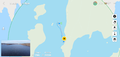
| Fri 2 Apr 2021 in Orudden: 56.1377595, 14.4736326 geohashing.info google osm bing/os kml crox |
Location
This Geohash is located in a lake in Bromölla, near the bathing place Orudden
Participants
gnuX Emeli
Plans
We've made some geohash expeditions the last couple of months but not bothered with the wiki-faffing, but this looked like a great opportunity to get our of the house for a longer trip and do some drone flying!
Expedition
We took the T.A.R.D.I.S out for a drive, passing by Kristianstad for a quick charge up to have enough juice for the ride back. We arrived at Orudden. I was hoping the DJI Fly app would have an setting to show coordinates of the drone while flying, but no such luck - making hitting the hash location a bit more challenging. I did my best trying to get the drone in the exact location and I think I got it within the margin of error for GPS. Afterwards I flew a lap around the small island to the west of the hash, got a battery warning midway through and had a few stressful minutes flying back against the wind hoping to not drop the drone into the lake :O
Tracklog
Photos
Proof?
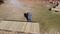
Grins from above
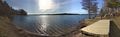
The view


Achievements
gnuX earned the Geohash by proxy achievement
|