Difference between revisions of "2022-02-27 44 -123"
Michael5000 (talk | contribs) |
m (subst-ing) |
||
| (5 intermediate revisions by 2 users not shown) | |||
| Line 8: | Line 8: | ||
And DON'T FORGET to add your expedition and the best photo you took to the gallery on the Main Page! We'd love to read your report, but that means we first have to discover it! :) | And DON'T FORGET to add your expedition and the best photo you took to the gallery on the Main Page! We'd love to read your report, but that means we first have to discover it! :) | ||
-->{{meetup graticule | -->{{meetup graticule | ||
| − | | lat= | + | | lat=44 |
| − | | lon= | + | | lon=-123 |
| − | | date= | + | | date=2022-02-27 |
}}<!-- edit as necessary --> | }}<!-- edit as necessary --> | ||
__NOTOC__ | __NOTOC__ | ||
== Location == | == Location == | ||
| − | + | ||
| + | On the shoulder of Ellendale Road, just west of Dallas. | ||
== Participants == | == Participants == | ||
| Line 20: | Line 21: | ||
*[[User:Michael5000|Michael5000]] | *[[User:Michael5000|Michael5000]] | ||
| − | == | + | == Expedition == |
| − | + | ||
| + | I drove up from [[2022-02-27 43 -123]], catching Hwy 99W at little Monroe and continuing through Corvallis and Monmouth before heading west to Dallas. Navigating by GPS and not realizing that the Dallas street grid is largely bisected by Rickreall Creek, I managed to get lost in a much smaller town than one would usually expect to get lost in. So that was fun. | ||
| − | + | The hashpoint itself was basically a mailbox in front of somebody's house. They may have wondered why someone parked down the street, walked by their house, walked back to his car, and drove away, but if they did I bet the question didn't puzzle them very long. | |
| − | |||
== Photos == | == Photos == | ||
<gallery perrow="5"> | <gallery perrow="5"> | ||
| − | File:2022-02-27 44 -123 1.jpg | + | File:2022-02-27 44 -123 1.jpg|The intersection a short distance from the hashpoint. |
| − | File:2022-02-27 44 -123 | + | File:2022-02-27 44 -123 2.jpg|The hashpoint was right in front of this house -- just slightly to the left of the photo, actually. |
</gallery> | </gallery> | ||
| − | |||
== Achievements == | == Achievements == | ||
{{#vardefine:ribbonwidth|800px}} | {{#vardefine:ribbonwidth|800px}} | ||
<!-- Add any achievement ribbons you earned below, or remove this section --> | <!-- Add any achievement ribbons you earned below, or remove this section --> | ||
| + | {{Multihash2 | count = 2 | date = 2022-02-27 | name = [[User:Michael5000|Michael5000]] }} | ||
| + | |||
| + | *Eight February 2022 expeditions with seven successful shattered my previous February record, 3/3. | ||
[[Category:Expeditions]] | [[Category:Expeditions]] | ||
[[Category:Expeditions with photos]] | [[Category:Expeditions with photos]] | ||
[[Category:Coordinates reached]] | [[Category:Coordinates reached]] | ||
| + | {{location|US|OR|PO}} | ||
Latest revision as of 20:44, 24 May 2024
| Sun 27 Feb 2022 in 44,-123: 44.9300790, -123.3497674 geohashing.info google osm bing/os kml crox |
Location
On the shoulder of Ellendale Road, just west of Dallas.
Participants
Expedition
I drove up from 2022-02-27 43 -123, catching Hwy 99W at little Monroe and continuing through Corvallis and Monmouth before heading west to Dallas. Navigating by GPS and not realizing that the Dallas street grid is largely bisected by Rickreall Creek, I managed to get lost in a much smaller town than one would usually expect to get lost in. So that was fun.
The hashpoint itself was basically a mailbox in front of somebody's house. They may have wondered why someone parked down the street, walked by their house, walked back to his car, and drove away, but if they did I bet the question didn't puzzle them very long.
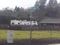
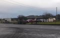
Photos
The intersection a short distance from the hashpoint.
The hashpoint was right in front of this house -- just slightly to the left of the photo, actually.


Achievements
Michael5000 earned the Multihash Achievement
|
- Eight February 2022 expeditions with seven successful shattered my previous February record, 3/3.