Difference between revisions of "2008-07-15 41 -71"
imported>Thomcat (category and map added) |
m (fix, sorry) |
||
| (7 intermediate revisions by 5 users not shown) | |||
| Line 1: | Line 1: | ||
==The Location== | ==The Location== | ||
| − | + | {{egl|2008-07-15|41|-72|text=Map Coordinates}} | |
The site is located in Smithfield, RI, near the intersection of Route 7 and Route 116. It is several hundred meters into the forest, with no simple and reliable access. | The site is located in Smithfield, RI, near the intersection of Route 7 and Route 116. It is several hundred meters into the forest, with no simple and reliable access. | ||
| Line 17: | Line 17: | ||
Image:2008-07-15-41-71-06.jpg|Some naturally occurring metal scrap, and a tire. There were little pockets of trash all over the place. | Image:2008-07-15-41-71-06.jpg|Some naturally occurring metal scrap, and a tire. There were little pockets of trash all over the place. | ||
Image:2008-07-15-41-71-07.jpg|Several of these blank signs dotted the landscape. It looked like they should have said "No Trespassing", but they said nothing. | Image:2008-07-15-41-71-07.jpg|Several of these blank signs dotted the landscape. It looked like they should have said "No Trespassing", but they said nothing. | ||
| − | Image:2008-07-15-41-71-08.jpg| | + | Image:2008-07-15-41-71-08.jpg|Beginneth the construction. This yet-unnamed road proceeded from Route 7, crossing Lydia Ann path. Several dirt roads and trails traversed the forest, but I decided to eschew the hash site proper (perhaps 200 meters from the closest of these photos) and head towards the construction. |
Image:2008-07-15-41-71-09.jpg|The initial, finished stretch of road ends in a small circle of pavement. Immediately beyond this were some unoccupied bulldozers (no, they didn't [http://www.marcellosendos.ch/comics/ch/1987/03/19870320.gif leave the keys]). | Image:2008-07-15-41-71-09.jpg|The initial, finished stretch of road ends in a small circle of pavement. Immediately beyond this were some unoccupied bulldozers (no, they didn't [http://www.marcellosendos.ch/comics/ch/1987/03/19870320.gif leave the keys]). | ||
Image:2008-07-15-41-71-10.jpg|The road proceeds further back into the woods. It's just as paved, but with no streetlights, painted lines, or other such accoutrements of civilization. | Image:2008-07-15-41-71-10.jpg|The road proceeds further back into the woods. It's just as paved, but with no streetlights, painted lines, or other such accoutrements of civilization. | ||
| Line 34: | Line 34: | ||
| graticule_link=Providence, Rhode Island | | graticule_link=Providence, Rhode Island | ||
}} | }} | ||
| + | |||
| + | == The consolation prize == | ||
| + | {{It's a kitty | latitude = 41 | longitude = -71 | date = 2008-07-15 | name = [[User:Ben|Ben]] | distraction = a road unknown to Google Maps | image = 2008-07-15-41-71-10.jpg}} | ||
[[Category:Expeditions]] | [[Category:Expeditions]] | ||
[[Category:Expeditions with photos]] | [[Category:Expeditions with photos]] | ||
| + | [[Category:Coordinates not reached]] | ||
| + | [[Category:Not reached - Mother Nature]] | ||
| + | {{location|US|RI|PR}} | ||
Latest revision as of 18:53, 18 January 2022
The Location
The site is located in Smithfield, RI, near the intersection of Route 7 and Route 116. It is several hundred meters into the forest, with no simple and reliable access.
The Geohash
Ben biked roughly 15 km to the vicinity of the site (not really recommended; Route 7 kind of sucks for biking). My initial approach was along Lydia Ann Road off of Route 7, as marked. This clearly used to be a road, but is really not suitable for cars any longer; it quickly becomes nothing more than a widened footpath. I shortly discovered that there is a brand new road, still under construction, that Google does not yet know about. Rather than bushwhacking through the woods to the hash site, I elected to explore the construction.
- A Work in Progress
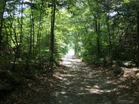
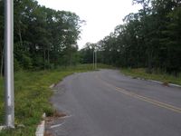
The first stretch of Lydia Ann Road. The initial paved segment and Route 7 are visible in the distance.
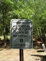
A short distance later, I came across this cemetery. Apparently, vandalism is punishable by law. Who knew?
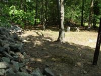
Most of the old cemetery can be seen here. It was very small, with perhaps half a dozen grave stones, and bordered by a stone wall on one side.
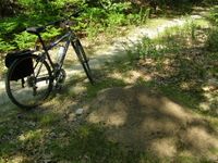
Further along, I came across a huge anthill, pictured above. My bike is alongside for comparison.
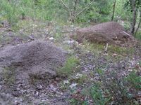
Two more huge anthills. There were ants all over the place; it sounded like it was raining if you stood still.
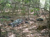
Some naturally occurring metal scrap, and a tire. There were little pockets of trash all over the place.
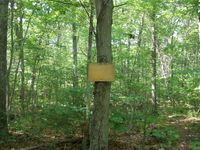
Several of these blank signs dotted the landscape. It looked like they should have said "No Trespassing", but they said nothing.
Beginneth the construction. This yet-unnamed road proceeded from Route 7, crossing Lydia Ann path. Several dirt roads and trails traversed the forest, but I decided to eschew the hash site proper (perhaps 200 meters from the closest of these photos) and head towards the construction.
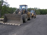
The initial, finished stretch of road ends in a small circle of pavement. Immediately beyond this were some unoccupied bulldozers (no, they didn't leave the keys).
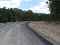
The road proceeds further back into the woods. It's just as paved, but with no streetlights, painted lines, or other such accoutrements of civilization.
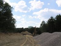
A bit further back and it starts to get truly gnarly. A water tower was visible just beyond the trees.
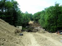
Clearly, still a work in progress. The cleared section went considerably farther back, as best I could tell. Given the seemingly active nature of the construction site (machinery left running, etc.), I elected to make myself scarce shortly after this shot.


Given how hilly the area is, I have to assume that this road is destined to be a residential development. No sign of houses yet, or any construction except the road itself. I can only imagine how much more forest will be cleared to support this future suburb.
| Tue 15 Jul 2008 in Providence: 41.9238259, -71.5172238 geohashing.info google osm bing/os kml crox |
The consolation prize
Ben earned the It's a kitty consolation prize
|