Difference between revisions of "2023-03-26 43 -123"
Michael5000 (talk | contribs) (→Location) |
m (subst-ing) |
||
| (2 intermediate revisions by 2 users not shown) | |||
| Line 8: | Line 8: | ||
And DON'T FORGET to add your expedition and the best photo you took to the gallery on the Main Page! We'd love to read your report, but that means we first have to discover it! :) | And DON'T FORGET to add your expedition and the best photo you took to the gallery on the Main Page! We'd love to read your report, but that means we first have to discover it! :) | ||
-->{{meetup graticule | -->{{meetup graticule | ||
| − | | lat= | + | | lat=43 |
| − | | lon= | + | | lon=-123 |
| − | | date= | + | | date=2023-03-26 |
}}<!-- edit as necessary --> | }}<!-- edit as necessary --> | ||
== Location == | == Location == | ||
| Line 16: | Line 16: | ||
== Participants == | == Participants == | ||
| − | + | *[[user:Michael5000|Michael5000]] | |
| − | |||
| − | == | + | == Expedition == |
| − | + | This hashpoint was just off a reasonable route to my parents' town, so I broke up the trip by stopping here. I had always kind of wondered about the "Green District" -- it turns out, predictably enough, that it's a little neighborhood named Green. I don't know what makes it a "district" though. | |
| − | + | Church was in full swing when I first drove by the hashpoint. I parked nearby and set off on a run looping around through the neighborhood, eventually reaching the hashpoint after about 4 3/4 miles, and then trotting back to the car. Then I drove off, remembered I didn't have any pictures yet, drove back, and took a few pictures. | |
| − | |||
| − | + | Then I resumed my trip! | |
| − | |||
== Photos == | == Photos == | ||
| − | |||
| − | |||
| − | |||
<gallery perrow="5"> | <gallery perrow="5"> | ||
| + | File:2023-03-26 43 -123 1.jpg|Looking my best! | ||
| + | File:2023-03-26 43 -123 2.jpg|The Green Community Church | ||
| + | File:2023-03-26 43 -123 3.jpg|Yep yep | ||
</gallery> | </gallery> | ||
| Line 40: | Line 37: | ||
__NOTOC__ | __NOTOC__ | ||
| − | |||
| − | |||
| − | |||
| − | |||
| − | |||
| − | |||
| − | |||
| − | |||
| − | |||
| − | |||
| − | |||
| − | |||
| − | |||
| − | |||
[[Category:Expeditions]] | [[Category:Expeditions]] | ||
| − | |||
[[Category:Expeditions with photos]] | [[Category:Expeditions with photos]] | ||
| − | |||
| − | |||
| − | |||
| − | |||
| − | |||
[[Category:Coordinates reached]] | [[Category:Coordinates reached]] | ||
| − | + | {{location|US|OR|DO}} | |
| − | |||
| − | |||
| − | |||
| − | |||
| − | |||
| − | |||
| − | |||
| − | |||
| − | |||
| − | |||
| − | |||
| − | |||
| − | |||
| − | |||
| − | |||
| − | |||
| − | |||
Latest revision as of 20:57, 24 May 2024
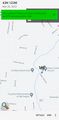
| Sun 26 Mar 2023 in 43,-123: 43.1593849, -123.3814724 geohashing.info google osm bing/os kml crox |
Location
Outside a church in the "Green District" suburb of Roseburg.
Participants
Expedition
This hashpoint was just off a reasonable route to my parents' town, so I broke up the trip by stopping here. I had always kind of wondered about the "Green District" -- it turns out, predictably enough, that it's a little neighborhood named Green. I don't know what makes it a "district" though.
Church was in full swing when I first drove by the hashpoint. I parked nearby and set off on a run looping around through the neighborhood, eventually reaching the hashpoint after about 4 3/4 miles, and then trotting back to the car. Then I drove off, remembered I didn't have any pictures yet, drove back, and took a few pictures.
Then I resumed my trip!
Photos

Looking my best!
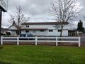
The Green Community Church
Yep yep


