Difference between revisions of "2023-08-01 53 9"
(Created the page as placeholder) |
m (subst-ing) |
||
| (19 intermediate revisions by 3 users not shown) | |||
| Line 1: | Line 1: | ||
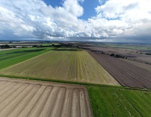
| − | + | [[Image:2023-08-01 53 9 - 11 Drone wide angle south.JPG|thumb|left]] | |
| − | |||
| − | |||
| − | [[Image:. | ||
| − | |||
| − | |||
{{meetup graticule | {{meetup graticule | ||
| − | | lat= | + | | lat=53 |
| − | | lon= | + | | lon=9 |
| − | | date= | + | | date=2023-08-01 |
}} | }} | ||
== Location == | == Location == | ||
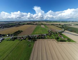
| + | In a wheat field near [[wikipedia:Krempe|Krempe]], [[wikipedia:Schleswig-Holstein|Schleswig-Holstein]]. | ||
| + | == Participants == | ||
| + | * [[User:Rsge|Rsge]] ([[User talk:Rsge|talk]]) | ||
| + | * [[User:π π π|π π π]] ([[User talk:Π π π|talk]]) | ||
| − | |||
| − | |||
| − | |||
| − | |||
== Plans == | == Plans == | ||
| + | === Rsge === | ||
| + | This hash placed right near [[2005-05-26|a retro hash I wanted to do as a sort of pilgrimage if you will]], so I planned to do two hashes in one trip. The weather was forecast to be showery, so I considered driving, but as the weather didn't look too bad (at first) and Krempe has it's own regional train station near the hashes, I decided to go by train and bike to save on emissions. I asked [[User:π π π|π π π]] if he wanted to come, too. He said yes; we'd take the same train and meet in the train or at Krempe station. | ||
| + | == Expedition == | ||
| + | === Rsge === | ||
| + | After I came home from a short trip to Hamburg with a few friends I packed my drone and some other stuff for the trip to the hashes. I wanted to take the bike to the train station and take it with me in the train to Krempe, as the way from there to the hashes was too long to walk. It was raining pretty bad, but I had already confirmed to [[User:π π π|π π π]] that I'd go by train. I bought a daysaver ticket for myself the usual way using the general DB Navigator app, but now I also needed a special ticket for my bike for the first time. I experimented a while to try and get it to work in the usual app but it didn't seem possible and time was running out, so I postponed to later and went on my way through the rain.<br> | ||
| + | My leather jacket (without hood) and sweatshirt jacket with rain proof hood were good, but my trousers were totally soaked after the first few hundred meters. Luckily the train station isn't too far away from my home. When I got there I started looking into the booking process for the bike ticket again and found out I could buy it on the DB website, not the app, or download a separate app for the specific traffic association, the HVV. The train was late a few minutes (typical DB...), so I had time to download the HVV app and buy the bike ticket there. Then the train arrived, I boarded and was finally out of the rain. [[User:π π π|π π π]] boarded the next station, but at another wagon, so we didn't see each other until we reached Krempe. The ride was uneventful, I just listened to music the whole way and wasn't checked.<br> | ||
| + | I got off at Krempe, where the sun was shining bright, and met [[User:π π π|π π π]] for the first time. We did a little small talk while we wheeled our bikes to the street, then got on, rode near the hash and parked our bikes at the street. Before us lay a small pasture and a wheat field. I didn't want to trample the wheat, so I considered aborting and just going by drone proxy, but [[User:π π π|π π π]] saw some tractor tracks we could use to get near the hash without trampling too much wheat, so we used these as far as possible.<br> | ||
| + | It had rained previously, so the ground was muddy and wet with some larger puddles. Luckily, I wore my safety boots, so I could march right through these - [[User:π π π|π π π]] wasn't as lucky...<br> | ||
| + | We got to the hash without further problems and without anyone noticing and took a few pictures. I unpacked and started my drone, took a few further photos and packed it up again. [[User:π π π|π π π]] and I each ate a cookie he brought as an award, then we went back the way we came, still trying to trample as few wheat as possible.<br> | ||
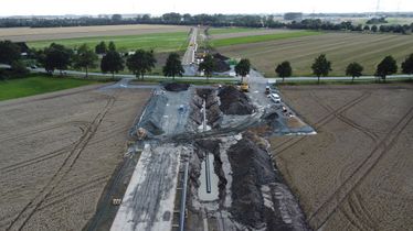
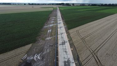
| + | When we got back I decided to also take a few pictures of the pipeline I had already seen on the way to my first "real" hash, so unpacked and packed the drone again.<br> | ||
| + | All the while, it began to rain a little bit again, but not too bad. We got on our bikes and continued to the next hash, the retro hash [[2005-05-26 53 9]].<br> | ||
| + | The rest of the report can be found [[2005-05-26 53 9|there]]. | ||
| − | == | + | === π π π === |
| + | Thanks for the writeup! I was very excited when I found out there was a new geohasher in the region and reached out so we could possibly arrange a meetup some day. Not even a month later, Rsge contacted me about this hash, combining the expedition with a pilgrimage to the hash of the date used in the original comic, 2005-05-26. Even though the hash would usually be to far for me to go for it and it was supposed to rain all day, I said yes so I could meet Rsge. | ||
| + | We coordinated the time and I took the A3 to Elmshorn, only barely making it by abandoning my shopping and returning all the groceries because the checkout queue at the supermarket next to the station was way too long. I had to wait a while in Elmshorn for the regional train, boarding somewhere in the middle. Only on the train did I find out Rsge was in the back, so I met him for the first time when we both exited at Krempe. We cycled 2 km to the hashfield, which was planted with wheat, and I convinced Rsge to accompany me along very muddy tractor tracks, all the while talking about subjects ranging from Geohashing and xkcd to drone flying, computer equipment and weather forecasts to trains and atheism. | ||
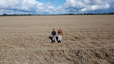
| + | I had to carefully navigate my way around the giant puddles on the tracks, dragging large amounts of mud with me, while Rsge just marched straight through. We wondered about entire regions of crushed or heavily bent wheat, which presumably were the result of extreme weather, and I was happy to see the hash lay in exactly such a region so we couldn't further damage the crops. Rsge flew his drone and took some truly amazing shots before we walked back 340 m to the edge of the field. After investigating the construction of an overground pipeline that is supposed to carry liquid nitrogen gas from the new LNG terminal in Brunsbüttel, we set off toward [[2005-05-26 53 9]] just as the rain started again. | ||
| − | + | We are very fortunate to live in region where it's possible to meet other, sometimes new geohashers. Many valiant lone hashers aren't so lucky. | |
| − | |||
| − | |||
| − | |||
| − | <gallery | + | == Photos == |
| + | === Rsge === | ||
| + | <gallery mode="packed" heights="140px"> | ||
| + | File:2023-08-01 53 9 - 01 On way - Tractor pathway.JPG | The tractor tracks we used on way to hash. | ||
| + | File:2023-08-01 53 9 - 02 GPS evidence near.PNG | Close GPS evidence. | ||
| + | File:2023-08-01 53 9 - 03 GPS evidence far.JPG | Far GPS evidence. | ||
| + | File:2023-08-01 53 9 - 05 Pano at hashpoint.JPG | A panorama from the ground at the hash. | ||
| + | File:2023-08-01 53 9 - 06 Drone downwards.JPG | The hash from a bird's eye view, straight down. | ||
| + | File:2023-08-01 53 9 - 08 Drone pano north.JPG | A panorama of the north of the hash via drone. | ||
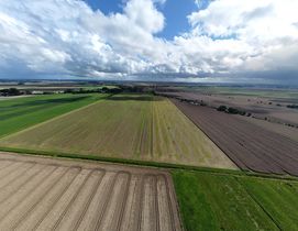
| + | File:2023-08-01 53 9 - 09 Drone wide angle north.JPG | A wide angle shot of the north of the hash. | ||
| + | File:2023-08-01 53 9 - 10 Drone pano south.JPG | A panorama of the south of the hash via drone. | ||
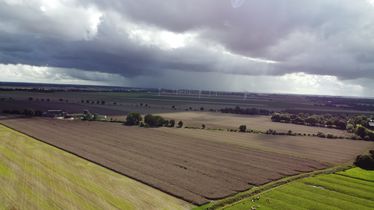
| + | File:2023-08-01 53 9 - 11 Drone wide angle south.JPG | A wide angle shot of the south of the hash. | ||
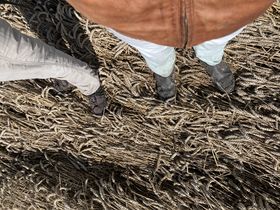
| + | File:2023-08-01 53 9 - 04 Feet at hashpoint.JPG | Rsge's and πππ's feet at the hash. | ||
| + | File:2023-08-01 53 9 - 07 Drone low.JPG | Rsge and πππ at the hash via drone. | ||
| + | File:2023-08-01 53 9 - 13 Rain in distance.JPG | Rain clouds in the distance. | ||
</gallery> | </gallery> | ||
| − | + | <gallery mode="packed" heights="140px"> | |
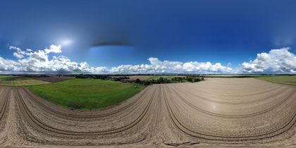
| + | File:2023-08-01 53 9 - 12 Drone 360 °.JPG | A 360 ° photo at the hash. Special viewer needed. | ||
| + | File:2023-08-01 53 9 - 14 Pipeline 1.JPG | A construction site of a pipeline near the hash 1. | ||
| + | File:2023-08-01 53 9 - 15 Pipeline 2.JPG | A construction site of a pipeline near the hash 2. | ||
| + | </gallery> | ||
| + | [[File:2023-08-01 53 9 - 07.1 Drone video.MP4|thumb|center|500px|A time lapse flight around the hash using a drone. '''Loud audio.''']] | ||
== Achievements == | == Achievements == | ||
{{#vardefine:ribbonwidth|100%}} | {{#vardefine:ribbonwidth|100%}} | ||
| + | {{Two to the N achievement | ||
| + | | latitude = 53 | ||
| + | | longitude = 9 | ||
| + | | date = 2023-08-01 | ||
| + | | name = [[User:Rsge|Rsge]] | ||
| + | | count = 1 | ||
| + | }} | ||
| + | {{Two to the N achievement | ||
| + | | latitude = 53 | ||
| + | | longitude = 9 | ||
| + | | date = 2023-08-01 | ||
| + | | name = [[User:Rsge|Rsge]] | ||
| + | | count = 1 | ||
| + | | reached = true | ||
| + | }} | ||
| + | {{land geohash | ||
| + | | latitude = 53 | ||
| + | | longitude = 9 | ||
| + | | date = 2023-08-01 | ||
| + | | name = [[User:Rsge|Rsge]] & [[User:π π π|π π π]] | ||
| + | | image = 2023-08-01 53 9 - 06 Drone downwards.JPG | ||
| + | }} | ||
| + | <!--{{bicycle geohash | ||
| + | | latitude = 53 | ||
| + | | longitude = 9 | ||
| + | | date = 2023-08-01 | ||
| + | | name = [[User:Rsge|]] & [[User:π π π|]] | ||
| + | | image = 2005-05-26 53 9 - 02 On way - Bike parking spot.JPG | ||
| + | }} | ||
| + | Don't think this one counts since we didn't cycle the entire way.--> | ||
| + | {{public transport geohash | ||
| + | | latitude = 53 | ||
| + | | longitude = 9 | ||
| + | | date = 2023-08-01 | ||
| + | | name = [[User:Rsge|Rsge]] & [[User:π π π|π π π]] | ||
| + | | image = 2023-08-01 53 9 - 07 Drone low.JPG | ||
| + | }} | ||
| + | {{meet-up | ||
| + | | latitude = 53 | ||
| + | | longitude = 9 | ||
| + | | date = 2023-08-01 | ||
| + | | name = [[User:Rsge|Rsge]] & [[User:π π π|π π π]] | ||
| + | | image = 2023-08-01 53 9 - 07 Drone low.JPG | ||
| + | }} | ||
__NOTOC__ | __NOTOC__ | ||
| − | |||
| − | |||
| − | |||
| − | |||
| − | |||
[[Category:Expeditions]] | [[Category:Expeditions]] | ||
[[Category:Expeditions with photos]] | [[Category:Expeditions with photos]] | ||
| − | + | [[Category:Expeditions with videos]] | |
[[Category:Coordinates reached]] | [[Category:Coordinates reached]] | ||
| − | + | {{location|DE|SH|IZ}} | |
| − | |||
| − | |||
| − | |||
| − | |||
| − | |||
| − | |||
| − | |||
Latest revision as of 21:03, 24 May 2024
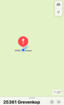
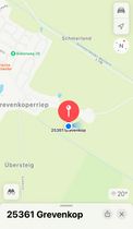
| Tue 1 Aug 2023 in 53,9: 53.8353497, 9.5060387 geohashing.info google osm bing/os kml crox |
Location
In a wheat field near Krempe, Schleswig-Holstein.
Participants
Plans
Rsge
This hash placed right near a retro hash I wanted to do as a sort of pilgrimage if you will, so I planned to do two hashes in one trip. The weather was forecast to be showery, so I considered driving, but as the weather didn't look too bad (at first) and Krempe has it's own regional train station near the hashes, I decided to go by train and bike to save on emissions. I asked π π π if he wanted to come, too. He said yes; we'd take the same train and meet in the train or at Krempe station.
Expedition
Rsge
After I came home from a short trip to Hamburg with a few friends I packed my drone and some other stuff for the trip to the hashes. I wanted to take the bike to the train station and take it with me in the train to Krempe, as the way from there to the hashes was too long to walk. It was raining pretty bad, but I had already confirmed to π π π that I'd go by train. I bought a daysaver ticket for myself the usual way using the general DB Navigator app, but now I also needed a special ticket for my bike for the first time. I experimented a while to try and get it to work in the usual app but it didn't seem possible and time was running out, so I postponed to later and went on my way through the rain.
My leather jacket (without hood) and sweatshirt jacket with rain proof hood were good, but my trousers were totally soaked after the first few hundred meters. Luckily the train station isn't too far away from my home. When I got there I started looking into the booking process for the bike ticket again and found out I could buy it on the DB website, not the app, or download a separate app for the specific traffic association, the HVV. The train was late a few minutes (typical DB...), so I had time to download the HVV app and buy the bike ticket there. Then the train arrived, I boarded and was finally out of the rain. π π π boarded the next station, but at another wagon, so we didn't see each other until we reached Krempe. The ride was uneventful, I just listened to music the whole way and wasn't checked.
I got off at Krempe, where the sun was shining bright, and met π π π for the first time. We did a little small talk while we wheeled our bikes to the street, then got on, rode near the hash and parked our bikes at the street. Before us lay a small pasture and a wheat field. I didn't want to trample the wheat, so I considered aborting and just going by drone proxy, but π π π saw some tractor tracks we could use to get near the hash without trampling too much wheat, so we used these as far as possible.
It had rained previously, so the ground was muddy and wet with some larger puddles. Luckily, I wore my safety boots, so I could march right through these - π π π wasn't as lucky...
We got to the hash without further problems and without anyone noticing and took a few pictures. I unpacked and started my drone, took a few further photos and packed it up again. π π π and I each ate a cookie he brought as an award, then we went back the way we came, still trying to trample as few wheat as possible.
When we got back I decided to also take a few pictures of the pipeline I had already seen on the way to my first "real" hash, so unpacked and packed the drone again.
All the while, it began to rain a little bit again, but not too bad. We got on our bikes and continued to the next hash, the retro hash 2005-05-26 53 9.
The rest of the report can be found there.
π π π
Thanks for the writeup! I was very excited when I found out there was a new geohasher in the region and reached out so we could possibly arrange a meetup some day. Not even a month later, Rsge contacted me about this hash, combining the expedition with a pilgrimage to the hash of the date used in the original comic, 2005-05-26. Even though the hash would usually be to far for me to go for it and it was supposed to rain all day, I said yes so I could meet Rsge.
We coordinated the time and I took the A3 to Elmshorn, only barely making it by abandoning my shopping and returning all the groceries because the checkout queue at the supermarket next to the station was way too long. I had to wait a while in Elmshorn for the regional train, boarding somewhere in the middle. Only on the train did I find out Rsge was in the back, so I met him for the first time when we both exited at Krempe. We cycled 2 km to the hashfield, which was planted with wheat, and I convinced Rsge to accompany me along very muddy tractor tracks, all the while talking about subjects ranging from Geohashing and xkcd to drone flying, computer equipment and weather forecasts to trains and atheism.
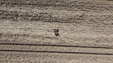
I had to carefully navigate my way around the giant puddles on the tracks, dragging large amounts of mud with me, while Rsge just marched straight through. We wondered about entire regions of crushed or heavily bent wheat, which presumably were the result of extreme weather, and I was happy to see the hash lay in exactly such a region so we couldn't further damage the crops. Rsge flew his drone and took some truly amazing shots before we walked back 340 m to the edge of the field. After investigating the construction of an overground pipeline that is supposed to carry liquid nitrogen gas from the new LNG terminal in Brunsbüttel, we set off toward 2005-05-26 53 9 just as the rain started again.
We are very fortunate to live in region where it's possible to meet other, sometimes new geohashers. Many valiant lone hashers aren't so lucky.
Photos
Rsge
Achievements
Rsge earned the Two to the N achievement
|
Rsge earned the Two to the N achievement
|
Rsge & π π π earned the Land geohash achievement
|
Rsge & π π π earned the Public transport geohash achievement
|
Rsge & π π π earned the Meet-up achievement
|
