Difference between revisions of "2023-08-12 65 23"
m (Location) |
m (subst-ing) |
||
| (6 intermediate revisions by 2 users not shown) | |||
| Line 1: | Line 1: | ||
{{meetup graticule | {{meetup graticule | ||
| − | | lat= | + | | lat=65 |
| − | | lon= | + | | lon=23 |
| − | | date= | + | | date=2023-08-12 |
}} | }} | ||
== Location == | == Location == | ||
| Line 17: | Line 17: | ||
== Expedition == | == Expedition == | ||
| − | + | Me and my girlfriend took a bus from Oulu to Haparanda, and the returning bus would leave three and a half hours later. | |
| + | I brought my mountain bike and went cycling while my girlfriend stayed to shop at IKEA. | ||
| + | My trip to the geohash would take about two hours. | ||
| + | |||
| + | Off I went. | ||
| + | I had brought rain overalls in case it would begin to rain, but the forecasted rainfall decreased during the forenoon, and ultimately I did not get a single drop of rain. | ||
| + | It was partly cloudy and warm enough that I would have welcomed an occasional cooling shower. | ||
| + | The gravel road was not very good at all but easy enough to traverse with the mountain bike. | ||
| + | There were lots of mushrooms and berries in the forests, and I saw several parked cars of foragers. | ||
| + | |||
| + | The hashpoint was indeed only about 20 metres off the road. | ||
| + | The forest was surprisingly sparse there: it looked more like an opening or a semi-open line for forestry vehicles. | ||
| + | I could continue cycling after taking a few photos. | ||
| + | I took a shortcut to Vuono, a small village where I found [https://coord.info/GC6NMD5 a geocache], and found my way back to the city and IKEA. We finished the shopping together and left for Oulu in the returning bus. | ||
== Tracklog == | == Tracklog == | ||
| − | + | The tracklog only includes the parts near Haparanda, not the whole bus trip. | |
| + | |||
| + | {{tracklog | 2023-08-12 65 23 tracklog.gpx}} | ||
== Photos == | == Photos == | ||
| − | <!-- | + | <!-- Timestamps of the photos are all over the place because my phone was switching between Finnish and Swedish networks. |
| − | Image: | + | There is a time zone border in the international border. --> |
| − | -- | + | <gallery perrow="11"> |
| − | + | Image:2023-08-12 65 23 01-haparanda1.jpg | Just arrived in Haparanda. | |
| + | Image:2023-08-12 65 23 02-road1.jpg | Riding into the rainclouds... though I did not get any rain at any point. | ||
| + | Image:2023-08-12 65 23 03-road2.jpg | "Drive slowly, the whole %$&#@ way" | ||
| + | Image:2023-08-12 65 23 04-road3.jpg | Where I parked the bicycle, about 20 metres to go. | ||
| + | Image:2023-08-12 65 23 05-hashpoint.jpg | How the hashpoint surroundings looked like. | ||
| + | Image:2023-08-12 65 23 06-gpsr1.jpg | Proof of location. | ||
| + | Image:2023-08-12 65 23 07-gpsr2.jpg | Proof of date and time. | ||
| + | Image:2023-08-12 65 23 08-selfie.jpg | Selfie at the hashpoint. | ||
| + | Image:2023-08-12 65 23 09-road4.jpg | The shortcut road... more like a trail. | ||
| + | Image:2023-08-12 65 23 10-haparanda2.jpg | Back in Haparanda, sitting in the bus. | ||
| + | Image:2023-08-12 65 23 11-oulu.jpg | Back in Oulu. | ||
</gallery> | </gallery> | ||
== Achievements == | == Achievements == | ||
| + | |||
| + | {{land geohash | ||
| + | | latitude=65 | ||
| + | | longitude=23 | ||
| + | | date=2023-08-12 | ||
| + | | name=[[User:Kripakko|Kripakko]] | ||
| + | }} | ||
| + | {{border geohash | ||
| + | | latitude=65 | ||
| + | | longitude=23 | ||
| + | | date=2023-08-12 | ||
| + | | name=[[User:Kripakko|Kripakko]] | ||
| + | | country1=Finland | ||
| + | | country2=Sweden | ||
| + | }} | ||
| + | {{public transport geohash | ||
| + | | latitude=65 | ||
| + | | longitude=23 | ||
| + | | date=2023-08-12 | ||
| + | | name=[[User:Kripakko|Kripakko]] | ||
| + | | busline=the Oulu–Tornio–Haparanda bus line | ||
| + | }} | ||
| + | {{graticule unlocked | ||
| + | | latitude=65 | ||
| + | | longitude=23 | ||
| + | | date=2023-08-12 | ||
| + | | name=[[User:Kripakko|Kripakko]] | ||
| + | }} | ||
__NOTOC__ | __NOTOC__ | ||
| − | |||
| − | |||
| − | |||
| − | |||
| − | |||
[[Category:Expeditions]] | [[Category:Expeditions]] | ||
| − | + | [[Category:Expeditions with photos]] | |
| − | [[Category:Expeditions with photos]] | ||
| − | |||
| − | |||
| − | |||
| − | |||
| − | |||
[[Category:Coordinates reached]] | [[Category:Coordinates reached]] | ||
| − | |||
| − | |||
| − | |||
| − | |||
| − | |||
| − | |||
| − | |||
| − | |||
| − | |||
| − | |||
| − | |||
| − | |||
| − | |||
| − | |||
| − | |||
| − | |||
| − | |||
{{location|SE|BD}} | {{location|SE|BD}} | ||
Latest revision as of 21:04, 24 May 2024
| Sat 12 Aug 2023 in 65,23: 65.8869944, 23.9711452 geohashing.info google osm bing/os kml crox |
Location
By a gravel road near Hoakananmaa, Haparanda.
The point on a topographic map: [1]
Participants
Plans
Thinking of going to Haparanda by bus and cycling the rest (roughly 15 km one way). Should be easily doable, though substantial rain has been predicted for the day.
Expedition
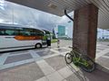
Me and my girlfriend took a bus from Oulu to Haparanda, and the returning bus would leave three and a half hours later. I brought my mountain bike and went cycling while my girlfriend stayed to shop at IKEA. My trip to the geohash would take about two hours.
Off I went. I had brought rain overalls in case it would begin to rain, but the forecasted rainfall decreased during the forenoon, and ultimately I did not get a single drop of rain. It was partly cloudy and warm enough that I would have welcomed an occasional cooling shower. The gravel road was not very good at all but easy enough to traverse with the mountain bike. There were lots of mushrooms and berries in the forests, and I saw several parked cars of foragers.
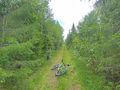
The hashpoint was indeed only about 20 metres off the road. The forest was surprisingly sparse there: it looked more like an opening or a semi-open line for forestry vehicles. I could continue cycling after taking a few photos. I took a shortcut to Vuono, a small village where I found a geocache, and found my way back to the city and IKEA. We finished the shopping together and left for Oulu in the returning bus.
Tracklog
The tracklog only includes the parts near Haparanda, not the whole bus trip.
Photos
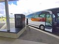
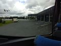
Just arrived in Haparanda.
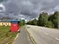
Riding into the rainclouds... though I did not get any rain at any point.
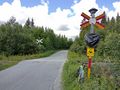
"Drive slowly, the whole %$&#@ way"
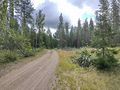
Where I parked the bicycle, about 20 metres to go.
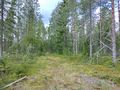
How the hashpoint surroundings looked like.
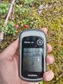
Proof of location.
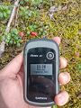
Proof of date and time.
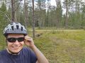
Selfie at the hashpoint.
The shortcut road... more like a trail.
Back in Haparanda, sitting in the bus.
Back in Oulu.


Achievements
Kripakko earned the Land geohash achievement
|
Kripakko earned the Border geohash achievement
|
Kripakko earned the Public transport geohash achievement
|
Kripakko earned the Graticule Unlocked Achievement
|