Difference between revisions of "2023-09-18 -37 145"
m (Location) |
|||
| (3 intermediate revisions by the same user not shown) | |||
| Line 28: | Line 28: | ||
I got home before 7, having done 31.8km by bike, and many more by train. I relaxed that evening watching [https://www.youtube.com/watch?v=UoYTKjvgsnk&ab_channel=Taitset a 40minute youtube video] all about the train line that had served me that day. | I got home before 7, having done 31.8km by bike, and many more by train. I relaxed that evening watching [https://www.youtube.com/watch?v=UoYTKjvgsnk&ab_channel=Taitset a 40minute youtube video] all about the train line that had served me that day. | ||
| + | === Photos === | ||
| + | <gallery perrow="5"> | ||
| + | |||
| + | Image:2023-09-18_-37_145_Johnwrw_1695126366290.jpg|Success | ||
| + | |||
| + | Image:2023-09-18_-37_145_Johnwrw_1695126390602.jpg|GPS proof | ||
| + | |||
| + | Image:2023-09-18_-37_145_Johnwrw_1695126409075.jpg|Cows | ||
| + | </gallery> | ||
| + | |||
| + | |||
| + | |||
| + | == Expedition 2 (Steve) == | ||
| + | === Out === | ||
| + | What a great location! And I was in the mood for a bike ride. So I decided to head off straight after lunch. And actually headed off at more like 4. | ||
| + | |||
| + | After considering a few faster options, I went with mostly bike path, getting on the main Yarra trail at the Guide Dog Centre. It was really pretty uneventful. I expected a lot of commuters cycling home but barely saw any cyclists at all, even though the weather was pretty perfect. Lots of walkers, prams, dogs. | ||
| + | |||
| + | And birds. The farther I got from the city, the more there were birds. Most of the classics: magpies, ducks, superb fairy-wrens, sulphur-crested cockatoos, corellas, galahs. A couple of geese, even. | ||
| + | |||
| + | As seems to happen a lot these days, I was reminded of other geohashes I had done as I passed nearby. [[2020-07-25_-37_145|This lockdown expedition in 2020]], [[2013-05-24_-37_145|this ancient one from 2013]] and this [[2021-10-03_-37_145|socially-distanced expedition in 2021]]. | ||
| + | |||
| + | As I turned up the Diamond Creek Trail, I noticed a few tiny improvements since I had been through last. | ||
| + | |||
| + | Arriving at a level crossing in Eltham (I think?) I had a sudden strong memory of a podcast I had been listening to last time I was there - a kind of fictional radio play about a plane crash. I lost interest as it got into conspiracy theories and woo. | ||
| − | + | The raucous cockatoos picked up as I got closer, and finally I was depositing the bike and striding in the slightly swampy undergrowth. I hadn't really paid any attention to the exact location of the point and was pleased by how deep in the undergrowth it was. And arriving in daylight, hooray! | |
| + | === Back === | ||
| + | Heading back, I followed my route as well as I could remember. Signage on the path is still pretty terrible so it's easy to get lost. As the light faded, I resorted to the map app to get home. | ||
| + | But...I put a bit too much faith in the app picking a sensible route, and it did not. I began to suspect that I hadn't come this way before as the route got hillier. And then left the bike path. Adventure? Or disaster? Only time would tell. | ||
| − | + | Suddenly, as I came down a steep road into a T-intersection, I came to one of the most challenging road crossings I have ever attempted, [https://www.google.com/maps/@-37.7376707,145.1344621,3a,90y,255.46h,70.99t/data=!3m7!1e1!3m5!1s03ci_zOTUyPzQ4HGxmDa6w!2e0!6shttps:%2F%2Fstreetviewpixels-pa.googleapis.com%2Fv1%2Fthumbnail%3Fpanoid%3D03ci_zOTUyPzQ4HGxmDa6w%26cb_client%3Dmaps_sv.tactile.gps%26w%3D203%26h%3D100%26yaw%3D12.543908%26pitch%3D0%26thumbfov%3D100!7i16384!8i8192!5m2!1e3!1e4?entry=ttu here]. In daylight it might be ok. At night, it was horrendous. The road bends too much to allow much visibility in either direction, and headlights make judging distances and speeds hard. My only tactic was to wait until there was no traffic from the right, venture out far enough to see if it was clear from the left, and hurry back if not. Eventually I made it across. | |
| − | |||
| − | |||
| − | |||
| − | |||
| − | + | The hills and dales were all pleasant enough, although I felt in completely unfamiliar surrounds. Eventually I reconnected onto the Plenty Trail, which I was at least a bit familiar with. | |
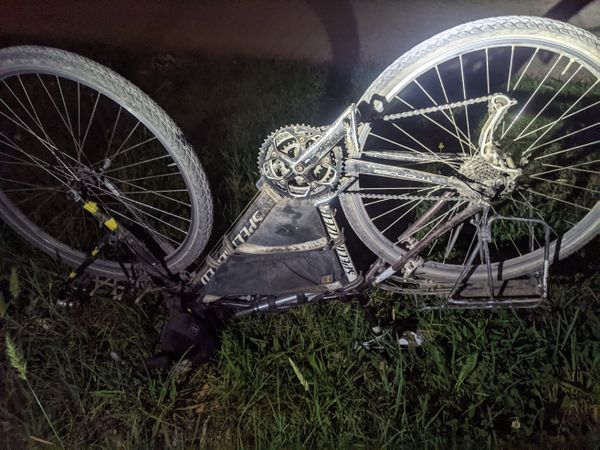
| − | + | A couple of times my chain had come off the back of my cassette, but in Ivanhoe East, I couldn't get the bike working again. Turning the cranks caused erratic skipping and jumping and a lot of friction. It looked like the freewheel was failing. Eventually I gave up and called KT, who came to my rescue. She'd just begun to think about preparing dinner and was very amenable to a hard pivot to takeaway pizza. | |
| − | + | === Photos === | |
| + | <gallery mode="packed" heights="300px"> | ||
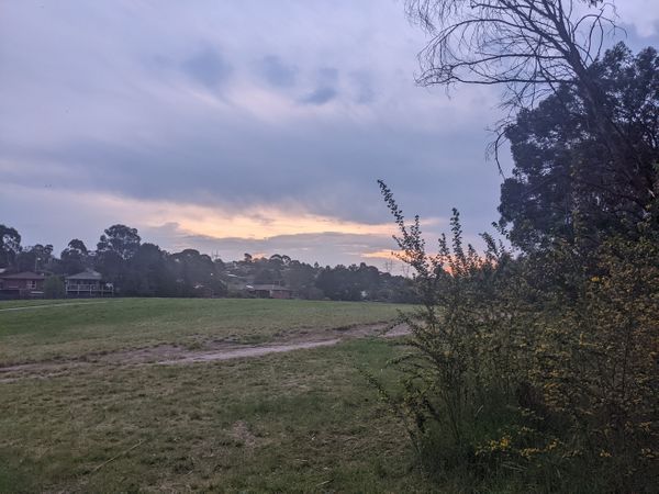
| + | File:PXL_20230918_073349558.jpg|Wallabies near Candlebark | ||
| + | File:PXL_20230918_081504488.jpg|Near the hash | ||
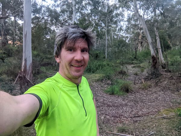
| + | File:PXL_20230918_081322928.jpg|Success! | ||
| + | File:PXL_20230918_093630697.jpg|Mechanical! | ||
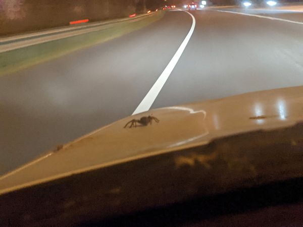
| + | File:PXL_20230918_101018700.jpg|Huntsman on the bonnet on the drive home | ||
</gallery> | </gallery> | ||
== Achievements == | == Achievements == | ||
{{#vardefine:ribbonwidth|100%}} | {{#vardefine:ribbonwidth|100%}} | ||
| − | + | {{bicycle geohash | |
| + | | latitude = -37 | ||
| + | | longitude = 145 | ||
| + | | date = 2023-09-18 | ||
| + | | name = Stevage | ||
| + | | distance = 30km | ||
| + | | bothways = true | ||
| + | }} | ||
__NOTOC__ | __NOTOC__ | ||
Latest revision as of 00:48, 12 July 2024
| Mon 18 Sep 2023 in -37,145: -37.6846499, 145.1546602 geohashing.info google osm bing/os kml crox |
Location
In bush by the side of Diamond Creek (the creek itself)
Participants
Expedition 1 (John)
The hash was appealing, but it was a long way away from me in Maribyrnong, so it took a while for me to make up my mind. At around 3, I decided that I had done enough work for the day and that I would launch an efficient speedy train both ways expedition, and be back in time for dinner. Trains both ways still necessitated a not insignificant ride to catch a train.
After some confusion, where I wanted to catch the train from Westgarth, but trains from there didn't seem to be going past Greensborough, I realised that the trains that go all the way to Diamond Creek/Hurstbridge were running express through Westgarth. I had to go to Clifton Hill instead. I eventually bundled myself out the door at 3:13, with exactly 35 minutes to ride a bit over 12 Ks across the city. A challenge when you consider the stop-start nature of city riding. I was pretty much flat out the whole way, but I got there with a few minutes to spare.
The train journey passed without drama, and I got to Diamond Creek station on time at 4:25. My plan was to ride the 6 or so Ks down along the path that follows the creek down to Eltham, where I could get a train home, naturally stopping to pick up the geohash on the way. If I was very efficient I might even make the 5pm train.
The path was lovely, the air was warm but had that freshness to it that comes from there being so much vegetation around. The ear-splitting screams of cockatoos only added to the serenity. I also spotted a couple of birds that I thought were probably common bronzewings (whose prettiness is undeserving of the 'common' name), but I didn't get a good glimpse of them.
I neared the hash, so I hid my bike just off the path, and ploughed into the bush. It was actually quite open, it seemed to be a lot of dried out pools that I'm sure will soon fill again next time it rains to any great extent. The GPS dance took longer than usual, but I eventually got a sub 1m reading. I returned to my bike, and continued on my way. I resigned myself to the fact that I was going to miss the 5pm train, so my onward progress was leisurely. Getting back closer to Eltham I came across a few inquisitive cows. I also passed several other farm animals.
Before I knew it, I was in Eltham and waiting on the platform for the 5:20 train. It arrived on time, and then in a flash I was at Westgarth. After a slow start, waiting for a train the other way at the level crossing, and then just missing the lights at High St, I got back to the inner circle trail, and rode home via royal park and the stock route, (and a quick visit to cheaper by miles).
I got home before 7, having done 31.8km by bike, and many more by train. I relaxed that evening watching a 40minute youtube video all about the train line that had served me that day.
Photos
Expedition 2 (Steve)
Out
What a great location! And I was in the mood for a bike ride. So I decided to head off straight after lunch. And actually headed off at more like 4.
After considering a few faster options, I went with mostly bike path, getting on the main Yarra trail at the Guide Dog Centre. It was really pretty uneventful. I expected a lot of commuters cycling home but barely saw any cyclists at all, even though the weather was pretty perfect. Lots of walkers, prams, dogs.
And birds. The farther I got from the city, the more there were birds. Most of the classics: magpies, ducks, superb fairy-wrens, sulphur-crested cockatoos, corellas, galahs. A couple of geese, even.
As seems to happen a lot these days, I was reminded of other geohashes I had done as I passed nearby. This lockdown expedition in 2020, this ancient one from 2013 and this socially-distanced expedition in 2021.
As I turned up the Diamond Creek Trail, I noticed a few tiny improvements since I had been through last.
Arriving at a level crossing in Eltham (I think?) I had a sudden strong memory of a podcast I had been listening to last time I was there - a kind of fictional radio play about a plane crash. I lost interest as it got into conspiracy theories and woo.
The raucous cockatoos picked up as I got closer, and finally I was depositing the bike and striding in the slightly swampy undergrowth. I hadn't really paid any attention to the exact location of the point and was pleased by how deep in the undergrowth it was. And arriving in daylight, hooray!
Back
Heading back, I followed my route as well as I could remember. Signage on the path is still pretty terrible so it's easy to get lost. As the light faded, I resorted to the map app to get home.
But...I put a bit too much faith in the app picking a sensible route, and it did not. I began to suspect that I hadn't come this way before as the route got hillier. And then left the bike path. Adventure? Or disaster? Only time would tell.
Suddenly, as I came down a steep road into a T-intersection, I came to one of the most challenging road crossings I have ever attempted, here. In daylight it might be ok. At night, it was horrendous. The road bends too much to allow much visibility in either direction, and headlights make judging distances and speeds hard. My only tactic was to wait until there was no traffic from the right, venture out far enough to see if it was clear from the left, and hurry back if not. Eventually I made it across.
The hills and dales were all pleasant enough, although I felt in completely unfamiliar surrounds. Eventually I reconnected onto the Plenty Trail, which I was at least a bit familiar with.
A couple of times my chain had come off the back of my cassette, but in Ivanhoe East, I couldn't get the bike working again. Turning the cranks caused erratic skipping and jumping and a lot of friction. It looked like the freewheel was failing. Eventually I gave up and called KT, who came to my rescue. She'd just begun to think about preparing dinner and was very amenable to a hard pivot to takeaway pizza.
Photos
Achievements
Stevage earned the Bicycle geohash achievement
|


