Difference between revisions of "2023-09-20 36 -80"
Michael5000 (talk | contribs) (Created page with "{{subst:Expedition}}") |
m (subst-ing) |
||
| (6 intermediate revisions by 2 users not shown) | |||
| Line 8: | Line 8: | ||
And DON'T FORGET to add your expedition and the best photo you took to the gallery on the Main Page! We'd love to read your report, but that means we first have to discover it! :) | And DON'T FORGET to add your expedition and the best photo you took to the gallery on the Main Page! We'd love to read your report, but that means we first have to discover it! :) | ||
-->{{meetup graticule | -->{{meetup graticule | ||
| − | | lat= | + | | lat=36 |
| − | | lon= | + | | lon=-80 |
| − | | date= | + | | date=2023-09-20 |
}}<!-- edit as necessary --> | }}<!-- edit as necessary --> | ||
== Location == | == Location == | ||
| − | + | On a little road southeast of Hillsville, in Carroll County, Virginia. | |
== Participants == | == Participants == | ||
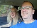
| − | + | *[[user:Michael5000|Michael5000]] | |
| − | + | *[[user:Mrs.5000|Mrs.5000]] | |
| − | |||
| − | |||
| − | |||
== Expedition == | == Expedition == | ||
| − | + | We started from Charleston, West Virginia, and stopped briefly at New River National Park on our way south by southeast. We followed US 15 for a while, then hopped onto I-77 when it stopped being a toll road, and followed it through a fairly epic tunnel into Virginia. Another 41 miles got us to the Hillsville exit, and we followed US 58 for a few miles as it rapidly shrank from a freeway to a divided highway to a rather narrow two-lane rural highway. Then, finally, we turned off onto Virginia highway 776, which is a rather grand number for a one-lane gravel road less than a kilometer long. It's also called Merrimac Road. | |
| − | + | It was a very pleasant road, though, with nice rural views and some cows at the end. The hashpoint was right there in the roadway, which was good as there wasn't really any way to park or pull over. But we had plenty of time to stop and take pictures. | |
| − | |||
== Photos == | == Photos == | ||
| − | |||
| − | |||
| − | |||
<gallery perrow="5"> | <gallery perrow="5"> | ||
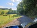
| + | File:2023-09-20 36 -80 a.jpg|Looking south down the road, from the hashpoint. | ||
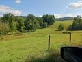
| + | File:2023-09-20 36 -80 b.jpg|View of the side, from the hashpoint. | ||
| + | File:2023-09-20 36 -80 c.jpg|Geohashers, at the hashpoint. | ||
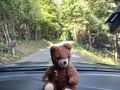
| + | File:2023-09-20 36 -80 d.jpg|Hashcot and view north, on the way back out. | ||
| + | File:2023-09-20 36 -80 e.jpg|There! | ||
</gallery> | </gallery> | ||
== Achievements == | == Achievements == | ||
{{#vardefine:ribbonwidth|100%}} | {{#vardefine:ribbonwidth|100%}} | ||
| − | |||
| + | *First expedition in the [[Winston-Salem, North Carolina|Winston-Salem graticule]] in more than 10 years. | ||
| + | *First expedition to the Virginia half of the Winston-Salem graticule. | ||
__NOTOC__ | __NOTOC__ | ||
| − | |||
| − | |||
| − | |||
| − | |||
| − | |||
| − | |||
| − | |||
| − | |||
| − | |||
| − | |||
| − | |||
| − | |||
[[Category:Expeditions]] | [[Category:Expeditions]] | ||
| − | |||
[[Category:Expeditions with photos]] | [[Category:Expeditions with photos]] | ||
| − | |||
| − | |||
| − | |||
| − | |||
| − | |||
[[Category:Coordinates reached]] | [[Category:Coordinates reached]] | ||
| − | + | {{location|US|VA|CL}} | |
| − | |||
| − | |||
| − | |||
| − | |||
| − | |||
| − | |||
| − | |||
| − | |||
| − | |||
| − | |||
| − | |||
| − | |||
| − | |||
| − | |||
| − | |||
| − | |||
| − | |||
Latest revision as of 21:06, 24 May 2024
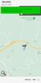
| Wed 20 Sep 2023 in 36,-80: 36.7554108, -80.6803437 geohashing.info google osm bing/os kml crox |
Location
On a little road southeast of Hillsville, in Carroll County, Virginia.
Participants
Expedition
We started from Charleston, West Virginia, and stopped briefly at New River National Park on our way south by southeast. We followed US 15 for a while, then hopped onto I-77 when it stopped being a toll road, and followed it through a fairly epic tunnel into Virginia. Another 41 miles got us to the Hillsville exit, and we followed US 58 for a few miles as it rapidly shrank from a freeway to a divided highway to a rather narrow two-lane rural highway. Then, finally, we turned off onto Virginia highway 776, which is a rather grand number for a one-lane gravel road less than a kilometer long. It's also called Merrimac Road.
It was a very pleasant road, though, with nice rural views and some cows at the end. The hashpoint was right there in the roadway, which was good as there wasn't really any way to park or pull over. But we had plenty of time to stop and take pictures.
Photos
Looking south down the road, from the hashpoint.
View of the side, from the hashpoint.
Geohashers, at the hashpoint.
Hashcot and view north, on the way back out.
There!


Achievements
- First expedition in the Winston-Salem graticule in more than 10 years.
- First expedition to the Virginia half of the Winston-Salem graticule.