Difference between revisions of "2023-10-12 37 -113"
Michael5000 (talk | contribs) (→Location) |
m (subst-ing) |
||
| (6 intermediate revisions by 3 users not shown) | |||
| Line 1: | Line 1: | ||
| − | + | {{meetup graticule | |
| − | + | | lat=37 | |
| − | + | | lon=-113 | |
| − | + | | date=2023-10-12 | |
| − | |||
| − | |||
| − | |||
| − | |||
| − | |||
| − | | lat= | ||
| − | | lon= | ||
| − | | date= | ||
}}<!-- edit as necessary --> | }}<!-- edit as necessary --> | ||
== Location == | == Location == | ||
| Line 16: | Line 8: | ||
== Participants == | == Participants == | ||
| − | [[User:Michael5000|Michael5000]] | + | [[User:Michael5000|Michael5000]] |
| − | == | + | == Expedition == |
| − | + | For two and a half days, I attended to the business end of the business-and-adventure trip, then reclaimed the Expedition Vehicle from the conference hotel parking garage and headed northeast towards this hashpoint. | |
| − | + | I've just looked up "OHV," and it stands for "Off-Highway Vehicles" -- dune buggies, in other words. Why do they call it Sand Mountain? Well, for the obvious reason, as it turns out. The sand in question is a kind of orange-pink color, with a moderate cover of desert plants and the occasional cactus, making this a distinctive and pretty place to take a walk. Or, I suppose, to drive a dune buggy. | |
| − | |||
| − | + | It was about a kilometer from the parking area to the hashpoint, but felt a little longer than that because walking on sand is a little effortful. But, it wasn't anything I couldn't handle. I headed back to the vehicle and pointed its nose [[2023-10-12 38 -113|one degree of latitude north]]. | |
| − | |||
== Photos == | == Photos == | ||
<gallery perrow="5"> | <gallery perrow="5"> | ||
| − | File:2023-10-12 37 -113 a.jpg| | + | File:2023-10-12 37 -113 a.jpg|I didn't bring an OHV |
| − | File:2023-10-12 37 -113 b.jpg| | + | File:2023-10-12 37 -113 b.jpg|Nice view from the parking lot |
| − | File:2023-10-12 37 -113 c.jpg| | + | File:2023-10-12 37 -113 c.jpg|Looking north from the hashpoint |
| − | File:2023-10-12 37 -113 d.jpg| | + | File:2023-10-12 37 -113 d.jpg|Looking south from the hashpoint |
| − | File:2023-10-12 37 -113 e.jpg| | + | File:2023-10-12 37 -113 e.jpg|The hashpoint |
| − | File:2023-10-12 37 -113 f.jpg| | + | File:2023-10-12 37 -113 f.jpg|Me, at the hashpoint |
</gallery> | </gallery> | ||
== Achievements == | == Achievements == | ||
{{#vardefine:ribbonwidth|100%}} | {{#vardefine:ribbonwidth|100%}} | ||
| − | + | {{Graticule unlocked | |
| − | |||
| − | |||
| − | |||
| − | |||
| − | |||
| − | + | | latitude = 37 | |
| + | | longitude = -113 | ||
| + | | date = 2023-10-12 | ||
| + | | name = Michael5000 | ||
| − | + | }} | |
| − | |||
| − | |||
| − | |||
| − | + | __NOTOC__ | |
| − | |||
[[Category:Expeditions]] | [[Category:Expeditions]] | ||
| − | |||
[[Category:Expeditions with photos]] | [[Category:Expeditions with photos]] | ||
| − | |||
| − | |||
| − | |||
| − | |||
| − | |||
[[Category:Coordinates reached]] | [[Category:Coordinates reached]] | ||
| − | + | {{location|US|UT|WN}} | |
| − | |||
| − | |||
| − | |||
| − | |||
| − | |||
| − | |||
| − | |||
| − | |||
| − | |||
| − | |||
| − | |||
| − | |||
| − | |||
| − | |||
| − | |||
| − | |||
| − | |||
Latest revision as of 21:08, 24 May 2024
| Thu 12 Oct 2023 in 37,-113: 37.0965110, -113.4116425 geohashing.info google osm bing/os kml crox |
Location
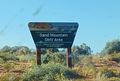
In the Sand Mountain OHV Area, east of St George.
Participants
Expedition
For two and a half days, I attended to the business end of the business-and-adventure trip, then reclaimed the Expedition Vehicle from the conference hotel parking garage and headed northeast towards this hashpoint.
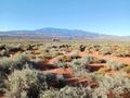
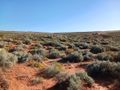
I've just looked up "OHV," and it stands for "Off-Highway Vehicles" -- dune buggies, in other words. Why do they call it Sand Mountain? Well, for the obvious reason, as it turns out. The sand in question is a kind of orange-pink color, with a moderate cover of desert plants and the occasional cactus, making this a distinctive and pretty place to take a walk. Or, I suppose, to drive a dune buggy.
It was about a kilometer from the parking area to the hashpoint, but felt a little longer than that because walking on sand is a little effortful. But, it wasn't anything I couldn't handle. I headed back to the vehicle and pointed its nose one degree of latitude north.
Photos
I didn't bring an OHV
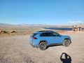
Nice view from the parking lot
Looking north from the hashpoint
Looking south from the hashpoint

The hashpoint

Me, at the hashpoint


Achievements
Michael5000 earned the Graticule Unlocked Achievement
|