Difference between revisions of "2024-05-11 -35 -57"
m (Location) |
m (subst-ing) |
||
| (One intermediate revision by one other user not shown) | |||
| Line 8: | Line 8: | ||
And DON'T FORGET to add your expedition and the best photo you took to the gallery on the Main Page! We'd love to read your report, but that means we first have to discover it! :) | And DON'T FORGET to add your expedition and the best photo you took to the gallery on the Main Page! We'd love to read your report, but that means we first have to discover it! :) | ||
-->{{meetup graticule | -->{{meetup graticule | ||
| − | | lat= | + | | lat=-35 |
| − | | lon= | + | | lon=-57 |
| − | | date= | + | | date=2024-05-11 |
}}<!-- edit as necessary --> | }}<!-- edit as necessary --> | ||
== Location == | == Location == | ||
| Line 20: | Line 20: | ||
== Plans == | == Plans == | ||
| − | |||
| − | |||
I will take a bus from Buenos Aires to Chascomús which is a little less than two hours. The point is very close to the bus station, only 1km so I will walk there and take proof. Then I will stay a little in the town, go to a Japanese Torii that is there, jog by the lake and go to a train museum, then take a bus back to Buenos Aires. Hopefully this will unlock this graticule and be my first successful expedition. | I will take a bus from Buenos Aires to Chascomús which is a little less than two hours. The point is very close to the bus station, only 1km so I will walk there and take proof. Then I will stay a little in the town, go to a Japanese Torii that is there, jog by the lake and go to a train museum, then take a bus back to Buenos Aires. Hopefully this will unlock this graticule and be my first successful expedition. | ||
| Line 27: | Line 25: | ||
== Expedition == | == Expedition == | ||
| − | + | ||
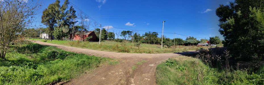
| + | I took the train to the bus terminal (10km) where I took the bus to Chascomús (130km), the point was just 1km away from the chascomús bus terminal, so I walked. I had to cross some train tracks and a road. There was no cat but there where a bunch of dogs that made noise as I walked (good boys). The point was on public road so I reached it easily. Then I strolled through the town, had lunch, It was a lovely day. | ||
== Tracklog == | == Tracklog == | ||
| − | + | {{tracklog|2024_05_11_-35_-57.gpx}} | |
== Photos == | == Photos == | ||
| Line 36: | Line 35: | ||
Image:2020-##-## ## ## Alpha.jpg | Witty Comment | Image:2020-##-## ## ## Alpha.jpg | Witty Comment | ||
--> | --> | ||
| − | <gallery | + | <gallery mode="packed" heights="200px"> |
| + | Image:2024_05_11_-35_-57_tracks.jpg | Tracks | ||
| + | Image:2024_05_11_-35_-57_site.jpg | Site | ||
| + | Image:-2024_05_11_-35_-57_proof.jpg | Proof | ||
| + | Image:2024_05_11_-35_-57_grin.jpg | Grin | ||
| + | Image:2024_05_11_-35_-57_surroundings.jpg | Surroundings | ||
| + | |||
</gallery> | </gallery> | ||
== Achievements == | == Achievements == | ||
{{#vardefine:ribbonwidth|100%}} | {{#vardefine:ribbonwidth|100%}} | ||
| − | + | {{land geohash | |
| − | + | | latitude = -35 | |
| + | | longitude = -57 | ||
| + | | date = 2024-05-11 | ||
| + | | name = Jota | ||
| + | | image = 2024_05_11_-35_-57_site.jpg | ||
| + | }} | ||
| + | {{Graticule unlocked | ||
| + | | latitude = -35 | ||
| + | | longitude = -57 | ||
| + | | date = 2024-05-11 | ||
| + | | name = Jota | ||
| + | | image = 2024_05_11_-35_-57_site.jpg | ||
| + | }} | ||
| + | {{Public transport geohash | ||
| + | | latitude = -35 | ||
| + | | longitude = -57 | ||
| + | | date = 2024-05-11 | ||
| + | | name = Jota | ||
| + | | busline = bus | ||
| + | }} | ||
| + | {{Two to the N achievement | ||
| + | | count = 0 | ||
| + | | latitude = -35 | ||
| + | | longitude = -57 | ||
| + | | date = 2024-05-11 | ||
| + | | name = Jota | ||
| + | | reached = true | ||
| + | }} | ||
| + | {{Two to the N achievement | ||
| + | | count = 1 | ||
| + | | latitude = -35 | ||
| + | | longitude = -57 | ||
| + | | date = 2024-05-11 | ||
| + | | name = Jota | ||
| + | }} | ||
__NOTOC__ | __NOTOC__ | ||
| − | |||
| − | |||
| − | |||
| − | |||
[[Category:Expeditions]] | [[Category:Expeditions]] | ||
| − | |||
[[Category:Expeditions with photos]] | [[Category:Expeditions with photos]] | ||
| − | |||
| − | |||
| − | |||
| − | |||
[[Category:Coordinates reached]] | [[Category:Coordinates reached]] | ||
| − | + | {{user categories|user=Jota|foot=3.58|train=18.54|bus=259.26}} | |
| − | |||
| − | |||
| − | |||
| − | |||
| − | |||
| − | |||
| − | |||
| − | |||
| − | |||
| − | |||
{{location|AR|B}} | {{location|AR|B}} | ||
Latest revision as of 21:20, 24 May 2024
| Sat 11 May 2024 in -35,-57: -35.5800480, -57.9747232 geohashing.info google osm bing/os kml crox |
Location
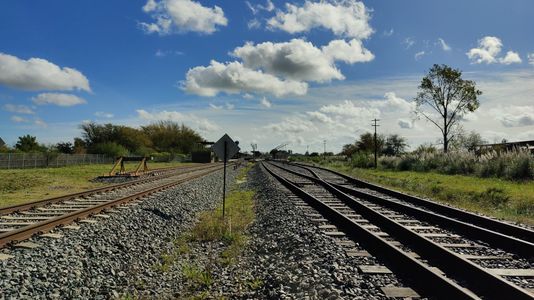
Close to Chascomús' train station
Participants
Plans
I will take a bus from Buenos Aires to Chascomús which is a little less than two hours. The point is very close to the bus station, only 1km so I will walk there and take proof. Then I will stay a little in the town, go to a Japanese Torii that is there, jog by the lake and go to a train museum, then take a bus back to Buenos Aires. Hopefully this will unlock this graticule and be my first successful expedition.
Expedition
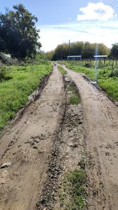
I took the train to the bus terminal (10km) where I took the bus to Chascomús (130km), the point was just 1km away from the chascomús bus terminal, so I walked. I had to cross some train tracks and a road. There was no cat but there where a bunch of dogs that made noise as I walked (good boys). The point was on public road so I reached it easily. Then I strolled through the town, had lunch, It was a lovely day.
Tracklog
Photos
Tracks
Site
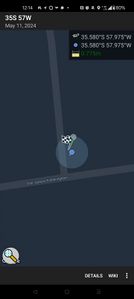
Proof
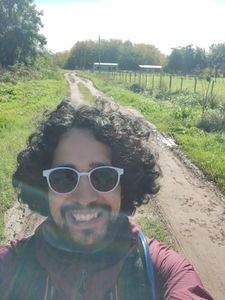
Grin
Surroundings


Achievements
Jota earned the Land geohash achievement
|
Jota earned the Graticule Unlocked Achievement
|
Jota earned the Public transport geohash achievement
|

- Meetup on 2024-05-11
- Meetup in -35 -57
- Expeditions with tracklogs
- Land geohash achievement
- Graticule unlocked achievement
- Public transport geohash achievement
- Two to the N achievement
- Expeditions
- Expeditions with photos
- Coordinates reached
- Expeditions by Jota
- Jota's expeditions by bus
- Jota's expeditions on foot
- Jota's expeditions by train
- Meetup in Provincia de Buenos Aires