Difference between revisions of "2024-07-17 52 13"
Coyotebush (talk | contribs) ([live picture]Corridor entrance) |
m (Location) |
||
| (One intermediate revision by one other user not shown) | |||
| Line 18: | Line 18: | ||
| + | *Walking! -- [[User:Coyotebush|Coyotebush]] ([[User talk:Coyotebush|talk]]) [https://openstreetmap.org/?mlat=52.51374088&mlon=13.52028563&zoom=16 @52.5137,13.5203] 13:53, 17 July 2024 (GMT+02:00) | ||
| + | I walked from the S-Bahn station and soon up a cobbled road with a narrow dirt footpath. Without noticing until later, I passed through an entrance gate to this industrial area. Saw workshops but also a drink vendor? Eventually came to the right building, which had a map of tenants. | ||
| + | |||
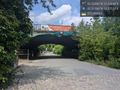
| + | As expected, I found a central corridor halfway along the east side. Someone else entered; I waited a minute and followed. In the corridor I reached the right longitude, and turning south I saw an open door labeled... WC. A very reasonable place to go! I went all the way to the end of this side corridor and watched for a while as the GPS distance gradually ticked down to around 1 meter. Used the convenient facilities, took a cleaned up selfie, and retraced my steps to the train. | ||
| − | |||
== Photos == | == Photos == | ||
<!-- | <!-- | ||
| Line 30: | Line 33: | ||
Image:2024-07-17_52_13_coyotebush_1721244324840.jpg|Entrance gate [https://openstreetmap.org/?mlat=52.51566111&mlon=13.52552500&zoom=16 @52.5157,13.5255] | Image:2024-07-17_52_13_coyotebush_1721244324840.jpg|Entrance gate [https://openstreetmap.org/?mlat=52.51566111&mlon=13.52552500&zoom=16 @52.5157,13.5255] | ||
| − | Image:2024-07- | + | Image:2024-07-17_52_13_coyotebush_1721244631594.jpg|Area map |
Image:2024-07-17_52_13_coyotebush_1721244363994.jpg|Building [https://openstreetmap.org/?mlat=52.52038889&mlon=13.52674722&zoom=16 @52.5204,13.5267] | Image:2024-07-17_52_13_coyotebush_1721244363994.jpg|Building [https://openstreetmap.org/?mlat=52.52038889&mlon=13.52674722&zoom=16 @52.5204,13.5267] | ||
| Line 36: | Line 39: | ||
Image:2024-07-17_52_13_coyotebush_1721244377007.jpg|Building map [https://openstreetmap.org/?mlat=52.52047500&mlon=13.52666667&zoom=16 @52.5205,13.5267] | Image:2024-07-17_52_13_coyotebush_1721244377007.jpg|Building map [https://openstreetmap.org/?mlat=52.52047500&mlon=13.52666667&zoom=16 @52.5205,13.5267] | ||
| − | Image:2024-07- | + | Image:2024-07-17_52_13_coyotebush_1721244649515.jpg|Corridor entrance |
Image:2024-07-17_52_13_coyotebush_1721244440125.jpg|Turning south [https://openstreetmap.org/?mlat=52.52083056&mlon=13.52643611&zoom=16 @52.5208,13.5264] | Image:2024-07-17_52_13_coyotebush_1721244440125.jpg|Turning south [https://openstreetmap.org/?mlat=52.52083056&mlon=13.52643611&zoom=16 @52.5208,13.5264] | ||
| Line 42: | Line 45: | ||
Image:2024-07-17_52_13_coyotebush_1721244502297.jpg|Goofy grin [https://openstreetmap.org/?mlat=52.52080833&mlon=13.52650000&zoom=16 @52.5208,13.5265] | Image:2024-07-17_52_13_coyotebush_1721244502297.jpg|Goofy grin [https://openstreetmap.org/?mlat=52.52080833&mlon=13.52650000&zoom=16 @52.5208,13.5265] | ||
| − | Image:2024-07-17_52_13_coyotebush_1721244549497.jpg|Map | + | Image:2024-07-17_52_13_coyotebush_1721244549497.jpg|Map screenshot |
| − | |||
| − | |||
| − | |||
</gallery> | </gallery> | ||
| Line 52: | Line 52: | ||
== Achievements == | == Achievements == | ||
{{#vardefine:ribbonwidth|100%}} | {{#vardefine:ribbonwidth|100%}} | ||
| + | |||
| + | {{Public transport geohash | latitude = 52 | longitude = 13 | date = 2024-07-17 | name = coyotebush }} | ||
__NOTOC__ | __NOTOC__ | ||
| − | |||
| − | |||
| − | |||
| − | |||
[[Category:Expeditions]] | [[Category:Expeditions]] | ||
| Line 63: | Line 61: | ||
[[Category:Coordinates reached]] | [[Category:Coordinates reached]] | ||
| − | + | {{location|DE|BE}} | |
| − | |||
| − | |||
| − | |||
| − | |||
| − | |||
| − | |||
| − | |||
Latest revision as of 15:42, 18 July 2024
| Wed 17 Jul 2024 in 52,13: 52.5207998, 13.5264776 geohashing.info google osm bing/os kml crox |
Location
Inside the Neues Wolllagerhaus in Berlin-Marzahn.
Participants
Plans
Train to Friedrichsfelde Ost, walk or bike the remaining distance, see if it's possible to get inside by visiting a business or something.
Expedition
- Walking! -- Coyotebush (talk) @52.5137,13.5203 13:53, 17 July 2024 (GMT+02:00)
I walked from the S-Bahn station and soon up a cobbled road with a narrow dirt footpath. Without noticing until later, I passed through an entrance gate to this industrial area. Saw workshops but also a drink vendor? Eventually came to the right building, which had a map of tenants.
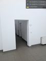
As expected, I found a central corridor halfway along the east side. Someone else entered; I waited a minute and followed. In the corridor I reached the right longitude, and turning south I saw an open door labeled... WC. A very reasonable place to go! I went all the way to the end of this side corridor and watched for a while as the GPS distance gradually ticked down to around 1 meter. Used the convenient facilities, took a cleaned up selfie, and retraced my steps to the train.
Photos
Entrance gate @52.5157,13.5255
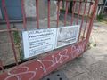
Area map
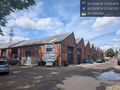
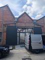
Building @52.5204,13.5267
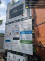
Building map @52.5205,13.5267
Corridor entrance
Turning south @52.5208,13.5264

Goofy grin @52.5208,13.5265
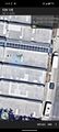
Map screenshot


Achievements
coyotebush earned the Public transport geohash achievement
|