Difference between revisions of "Szczecin, Poland"
From Geohashing
imported>Relet |
m (Marking as inactive due to no recent expeditions) |
||
| (40 intermediate revisions by 14 users not shown) | |||
| Line 1: | Line 1: | ||
| − | |||
{{graticule | {{graticule | ||
| − | | | + | | lat= 53 |
| + | | lon= 14 | ||
| + | | nw = [[Stralsund, Germany]] | ||
| + | | n = [[Dziwnów, Poland|Dziwnów]] | ||
| + | | ne = [[Kołobrzeg, Poland|Kołobrzeg]] | ||
| + | | w = [[Neubrandenburg, Germany]] | ||
| + | | name = [[Szczecin, Poland|Szczecin]] | ||
| + | | e = [[Stargard Szczeciński, Poland|Stargard Szczeciński]] | ||
| sw = [[Berlin, Germany]] | | sw = [[Berlin, Germany]] | ||
| − | }} | + | | s = [[Frankfurt (Oder), Germany]] |
| + | | se = [[Gorzów Wielkopolski, Poland|Gorzów Wielkopolski]] | ||
| + | }} | ||
| − | + | {{Today's location|lat=53|lon=14}} | |
| − | This [[graticule]] is at latitude 53, longitude 14. It is currently | + | This [[graticule]] is at latitude 53, longitude 14. It is currently active. It spans the Polish-German border with the largest cities being Szczecin and Schwedt/Oder respectively. A significant part of the graticule consists of water, with the Szczecin Lagoon (Zalew Szczeciński; Stettiner Haff), a tiny bit of the Baltic Sea, and the river Odra along the frontier. The rest of the landscape is mostly agricultural/forests. |
| − | { | + | == Land usage == |
| + | <pre> | ||
| + | 51.74% Fields | ||
| + | 0.17% Settlements | ||
| + | 25.58% Forests | ||
| + | 2.09% Natural reserves | ||
| + | 17.01% Water | ||
| + | 0.76% Near highways | ||
| + | 2.66% Near roads | ||
| + | </pre> | ||
| + | |||
| + | ===Maps and stats=== | ||
| + | [[File:Region 53,14 Admin 4.svg|200px]] | ||
| + | {| class="wikitable" | ||
| + | !Name!!Code!!area type!!country!!Geohash<br />probability | ||
| + | |- | ||
| + | |<span style="color:rgba(237,243,167,255)">■</span> Zachodniopomorskie||PL-32||land||Poland||59.3% | ||
| + | |- | ||
| + | |<span style="color:rgba(255,228,197,255)">■</span> Mecklenburg-Vorpommern||DE-MV||land||Germany||14.8% | ||
| + | |- | ||
| + | |<span style="color:rgba(246,248,179,255)">■</span> Brandenburg||DE-BB||land||Germany||13.5% | ||
| + | |- | ||
| + | |<span style="color:rgba(217,239,211,255)">■</span> Zachodniopomorskie||PL-32||incl. waters||Poland||67.7% | ||
| + | |- | ||
| + | |<span style="color:rgba(227,232,226,255)">■</span> Mecklenburg-Vorpommern||DE-MV||incl. waters||Germany||18.8% | ||
| + | |} | ||
| + | |||
| + | == Past Meetups == | ||
| + | |||
| + | * [[2024-02-12 53 14|2024-02-12]] - [[User:Fippe|Fippe]] visits a forest in Hintersee. | ||
| + | * [[2022-05-12 53 14|2022-05-12]] - [[User:Fippe|Fippe]] visits forest in Gryfino. | ||
| + | * [[2020-09-22 53 14|2020-09-22]] - A forest between Białuń and Żółwia Błoć. | ||
| + | * [[2020-08-04 53 14|2020-08-04]] - A swampy bank of Ina river. | ||
| + | * [[2020-08-01 53 14|2020-08-01]] - A small forest near Żdżary. | ||
| + | * [[2016-06-04 53 14|2016-06-04]] - Burowo near Goleniów, of course - some field. | ||
| + | * [[2016-01-23 53 14|2016-01-23]] - Żółwia near Goleniów, snowy field. | ||
| + | * [[2013-10-16 53 14|2013-10-16]] - Szczecin Dąbie, some small pond in an urban area. | ||
| + | * [[2009-09-27 53 14|2009-09-27]] - Jerrome and Lena looking at the haspoint from the shore of the Baltic Sea. | ||
| + | * [[2008-10-21 53 14|2008-10-21]] - relet gets wet deflowering the graticule and earning level 9 minesweeper. | ||
| + | |||
| + | [[Category:Inactive graticules]] | ||
| + | [[Category:Poland]] | ||
| + | [[Category:Germany]] | ||
| + | [[Category:Unlocked graticules]] | ||
Latest revision as of 00:42, 14 August 2024
This graticule is at latitude 53, longitude 14. It is currently active. It spans the Polish-German border with the largest cities being Szczecin and Schwedt/Oder respectively. A significant part of the graticule consists of water, with the Szczecin Lagoon (Zalew Szczeciński; Stettiner Haff), a tiny bit of the Baltic Sea, and the river Odra along the frontier. The rest of the landscape is mostly agricultural/forests.
Land usage
51.74%  Fields
0.17%   Settlements
25.58%  Forests
2.09%   Natural reserves
17.01%  Water
0.76%   Near highways
2.66%   Near roads
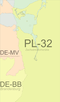
Maps and stats
| Name | Code | area type | country | Geohash probability |
|---|---|---|---|---|
| ■ Zachodniopomorskie | PL-32 | land | Poland | 59.3% |
| ■ Mecklenburg-Vorpommern | DE-MV | land | Germany | 14.8% |
| ■ Brandenburg | DE-BB | land | Germany | 13.5% |
| ■ Zachodniopomorskie | PL-32 | incl. waters | Poland | 67.7% |
| ■ Mecklenburg-Vorpommern | DE-MV | incl. waters | Germany | 18.8% |
Past Meetups
- 2024-02-12 - Fippe visits a forest in Hintersee.
- 2022-05-12 - Fippe visits forest in Gryfino.
- 2020-09-22 - A forest between Białuń and Żółwia Błoć.
- 2020-08-04 - A swampy bank of Ina river.
- 2020-08-01 - A small forest near Żdżary.
- 2016-06-04 - Burowo near Goleniów, of course - some field.
- 2016-01-23 - Żółwia near Goleniów, snowy field.
- 2013-10-16 - Szczecin Dąbie, some small pond in an urban area.
- 2009-09-27 - Jerrome and Lena looking at the haspoint from the shore of the Baltic Sea.
- 2008-10-21 - relet gets wet deflowering the graticule and earning level 9 minesweeper.
