Difference between revisions of "Schwerin, Germany"
imported>ZettS |
m (per Renaming Proposal) |
||
| (10 intermediate revisions by 3 users not shown) | |||
| Line 13: | Line 13: | ||
}} | }} | ||
| − | + | {{Today's location|lat=53|lon=11}} | |
This [[graticule]] is at latitude 53, longitude 11. It is currently inactive. This graticule contains parts of the [[Germany|German]] Bundesländer [[Germany/States|Mecklenburg-Vorpommern, Brandenburg, Niedersachsen (Lower Saxony) and Sachsen-Anhalt (Saxony-Anhalt)]]. | This [[graticule]] is at latitude 53, longitude 11. It is currently inactive. This graticule contains parts of the [[Germany|German]] Bundesländer [[Germany/States|Mecklenburg-Vorpommern, Brandenburg, Niedersachsen (Lower Saxony) and Sachsen-Anhalt (Saxony-Anhalt)]]. | ||
| Line 27: | Line 27: | ||
</pre> | </pre> | ||
| − | === | + | ===Maps and stats=== |
| + | [[File:Region 53,11 Admin 4.svg|200px]] | ||
| + | {| class="wikitable" | ||
| + | !Name!!Code!!area type!!Geohash<br />probability | ||
| + | |- | ||
| + | |<span style="color:rgba(255,204,204,255)">■</span> Mecklenburg-Vorpommern||MV||land||78.7% | ||
| + | |- | ||
| + | |<span style="color:rgba(237,244,168,255)">■</span> Brandenburg||BB||land||12.3% | ||
| + | |- | ||
| + | |<span style="color:rgba(255,253,192,255)">■</span> Niedersachsen||NI||land||7.3% | ||
| + | |- | ||
| + | |<span style="color:rgba(241,189,244,255)">■</span> Sachsen-Anhalt||ST||land||0.28% | ||
| + | |- | ||
| + | |<span style="color:rgba(226,219,229,255)">■</span> Mecklenburg-Vorpommern||MV||incl. waters||80.1% | ||
| + | |} | ||
| − | * [[ | + | ==Local Geohashers== |
| − | + | * [[User:badloginname|badloginname]] | |
| − | + | ||
| + | ==Recent Expeditions== | ||
| + | ''For all expeditions in this graticule, see [[Schwerin, Germany/Expeditions]].'' | ||
| + | {{:Schwerin, Germany/Expeditions}} | ||
| − | [[Category: | + | [[Category:Inactive graticules]] |
[[Category:Germany]] | [[Category:Germany]] | ||
| − | [[Category: | + | [[Category:Unlocked graticules]] |
| − | |||
| − | |||
| − | |||
Latest revision as of 02:23, 20 March 2024
| Kiel | Nykøbing Falster, Denmark | Rostock |
| Hamburg (East) | Schwerin | Güstrow |
| Braunschweig | Magdeburg | Brandenburg |
|
Today's location: geohashing.info google osm bing/os kml crox | ||
This graticule is at latitude 53, longitude 11. It is currently inactive. This graticule contains parts of the German Bundesländer Mecklenburg-Vorpommern, Brandenburg, Niedersachsen (Lower Saxony) and Sachsen-Anhalt (Saxony-Anhalt).
According to Land usage, the chance for your hash to fall into one of the following areas is:
62.04%	Fields
15.94%	Forests
12.09%	Natural reserves
4.51%	Roads
3.20%	Water
2.21%	Highways
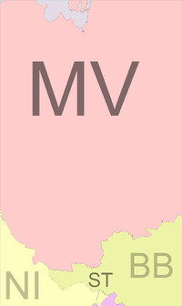
Maps and stats
| Name | Code | area type | Geohash probability |
|---|---|---|---|
| ■ Mecklenburg-Vorpommern | MV | land | 78.7% |
| ■ Brandenburg | BB | land | 12.3% |
| ■ Niedersachsen | NI | land | 7.3% |
| ■ Sachsen-Anhalt | ST | land | 0.28% |
| ■ Mecklenburg-Vorpommern | MV | incl. waters | 80.1% |
Local Geohashers
Recent Expeditions
For all expeditions in this graticule, see Schwerin, Germany/Expeditions.
![]() 2021-10-11 - Leidenfrost, π π π - on a vast field in Groß Buchholz, Perleberg, Brandenburg
2021-10-11 - Leidenfrost, π π π - on a vast field in Groß Buchholz, Perleberg, Brandenburg
![]() 2018-09-01 - Fippe - located in a glade near Gusborn.
2018-09-01 - Fippe - located in a glade near Gusborn.
![]() 2015-12-20 - ZettS - located on a field among the reeds south-east of the village Weitendorf on ...
2015-12-20 - ZettS - located on a field among the reeds south-east of the village Weitendorf on ...
![]() 2015-08-19 - Aba - Near a small canal close to the city of Schwerin (capital of Mecklenburg-Vo...
2015-08-19 - Aba - Near a small canal close to the city of Schwerin (capital of Mecklenburg-Vo...
![]() 2012-05-30 - alech - In a field next to Schloss Bothmer, Klütz.
2012-05-30 - alech - In a field next to Schloss Bothmer, Klütz.
![]() 2011-10-09 - lyx, relet - A lush forest close to highway 24.
2011-10-09 - lyx, relet - A lush forest close to highway 24.
![]() 2009-06-14 - relet - Could be a bosk. Just because I like the word.
2009-06-14 - relet - Could be a bosk. Just because I like the word.
![]() 2008-08-16 - Relet - This one seemed interesting, and it well proved to be. The hash was located...
2008-08-16 - Relet - This one seemed interesting, and it well proved to be. The hash was located...
