Difference between revisions of "2008-08-14 52 13"
m (Location correction) |
|||
| (One intermediate revision by one other user not shown) | |||
| Line 22: | Line 22: | ||
[[Category:Expeditions with photos]] | [[Category:Expeditions with photos]] | ||
[[Category:Coordinates reached]] | [[Category:Coordinates reached]] | ||
| + | {{location|DE|BB|HVL}} | ||
Latest revision as of 19:50, 16 May 2020
| Thu 14 Aug 2008 in Berlin: 52.5793654, 13.1369415 geohashing.info google osm bing/os kml crox |
The Tour
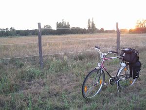
After work Phoenix mounted his trusty bike and headed for the hash into the Berlin-Brandenburg woods. Faithfully he drove towards Schönwalde along a beautioful but never-ending (or so it seems) alley, then into the forest, still on concrete track at first. This track was soon replaced by a bumpy field - time to become brave and switch on the Bluetooth GPS mouse. This guided Phoenix across an old bike track to yet another field with waist-high grass and bushes. Still he managed to get to the hash - exhausted but happy - not one minute before his friendly GPS mouse went to a silent sleep due to even worse exhaustion (battery power loss). What luck! So, with the proof taken Phoenix wandered a bit more through the woods in a south-like direction to finally find the village of Falkensee from where the way home led him across the border and into Berlin, and some time later safely home.
Photos
- can be explored here
