Difference between revisions of "2009-05-09 50 -119"
From Geohashing
imported>Rhonda m (2009-05-08 50 -119 moved to 2009-05-09 50 -119: oops, wrong date in page name) |
imported>Robyn (+Robyn's photos) |
||
| Line 33: | Line 33: | ||
==Photos== | ==Photos== | ||
| − | + | <gallery> | |
| + | Image:2009-05-09 50 -119.notthisway.JPG|We tried some wrong roads | ||
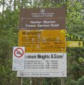
| + | Image:2009-05-09 50 -119.hb-fsr-sign.jpg|Then found the right road | ||
| + | Image:2009-05-09 50 -119.juventasmeadow.JPG|An unexpected meadow | ||
| + | Image:2009-05-09 50 -119.rhondastream.JPG|Across a stream and up a bank | ||
| + | Image:2009-05-09 50 -119.rhondaup.JPG|Along another road | ||
| + | Image:2009-05-09 50 -119.gps.JPG|At the coordinates | ||
| + | Image:2009-05-09 50 -119.summit.JPG|At the top of the hill | ||
| + | Image:2009-05-09 50 -119.beartracks.JPG|A bear took this road too. | ||
| + | </gallery> | ||
[[Category:Expeditions]] | [[Category:Expeditions]] | ||
[[Category:Coordinates reached]] | [[Category:Coordinates reached]] | ||
Revision as of 23:51, 11 May 2009
| Sat 9 May 2009 in 50,-119: 50.6692014, -119.0335969 geohashing.info google osm bing/os kml crox |
Logging road exploration. Deer skeleton, giant bumblebee, mosquitoes. Write up later.
Contents
Location
Up a hill, near a switchback on a forest service road near Mara Lake.


