Difference between revisions of "2010-04-25 45 -123"
imported>Aperfectring (+cats) |
imported>Aperfectring (→Photos) |
||
| Line 53: | Line 53: | ||
== Photos == | == Photos == | ||
| − | |||
| − | |||
| − | |||
<gallery perrow="4"> | <gallery perrow="4"> | ||
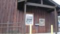
| + | Image:2010-04-25 45 -123 apr01.JPG|Hooray ATM! | ||
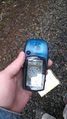
| + | Image:2010-04-25 45 -123 apr03.JPG|Proof | ||
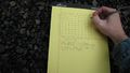
| + | Image:2010-04-25 45 -123 apr04.JPG|Avast relet, defend yourself! | ||
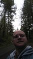
| + | Image:2010-04-25 45 -123 apr05.JPG|It's Me! | ||
| + | Image:2010-04-25 45 -123 apr06.JPG|Look one way | ||
| + | Image:2010-04-25 45 -123 apr08.JPG|Then another | ||
| + | Image:2010-04-25 45 -123 apr09.JPG|Finally up! | ||
</gallery> | </gallery> | ||
Revision as of 00:51, 26 April 2010
| Sun 25 Apr 2010 in 45,-123: 45.9440030, -123.0453958 geohashing.info google osm bing/os kml crox |
Location
In Camp Wilkerson Park, NE of Pittsburg, Oregon
Participants
Plans
Jim is hoping to head north and visit this hashpoint on the way.
Expedition
Aperfectring's Visit
Live reports
- Off to get gas, cash for the honor box, and then to the point! -- aperfectring @45.5218,-122.9718 13:57, 25 April 2010 (UTC)
- Got gas, but no atm, will get cash on the way. -- aperfectring @45.5296,-122.9558 14:04, 25 April 2010 (UTC)
- Got gas, but no atm, will get cash on the way. -- aperfectring @45.5296,-122.9558 14:04, 25 April 2010 (UTC)
- Coordinates reached, no cell signal @ the point, bad GPS signal as well. Proof is tenuous, but I am certain I made it. -- aperfectring @45.5287,-122.8660 16:39, 25 April 2010 (UTC)
Post-expedition Report
I started off this morning being woken up by one of my smoke detectors having a low battery, so starting to beep at me at about 6 AM. This rather annoyed me, so to prevent it from happening again, I went down to the garage, got my foldable table, a battery, and went back up to my bedroom to change the battery. As soon as that was done, I decided that rather than going back to sleep, I would go out and geohash this morning. I then proceeded to grab my gear, and head out the door by about 7AM.
I stopped to get gas and cash for the honor box that was supposed to be there, but the gas station had no ATM. I decided that I would just drive there, and find a place to stop on the way. I stopped at a credit union in Vernonia, Oregon and got cash. I then stopped at a convenience store, got a drink (to get change), and proceeded driving the mountain roads off towards the hashpoint.
The hashpoint itself was about 20ft off of a gravel road, but I couldn't get an accurate GPS fix. On the road I was getting anywhere between 15 and 90 ft to the hashpoint. I trudged into the woods a bit where it looked like the point was, and called it reached. I would most definitely get to the actual point, but technology prevented it. Proof pictures were taken, and the PBGH games concept officially ended its planning stage!
I then drove myself back along a different route, stopping for a decent breakfast and at a store to buy a new CD along the way. All in all a great trip!
Tracklog
Photos
Hooray ATM!
Proof
Avast relet, defend yourself!
It's Me!
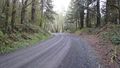
Look one way
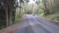
Then another
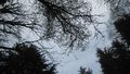
Finally up!


