Difference between revisions of "2011-07-18 52 1"
imported>Sourcerer ([live] Sourcerer arrived.) |
imported>Sourcerer |
||
| Line 1: | Line 1: | ||
| − | |||
| − | |||
| − | |||
| − | |||
| − | |||
| − | |||
| − | |||
| − | |||
| − | |||
| − | |||
{{meetup graticule | {{meetup graticule | ||
| − | | lat=52 | + | | lat=52 |
| − | | lon=1 | + | | lon=1 |
| − | | date=2011-07-18 | + | | date=2011-07-18 |
| + | | graticule_name=Norwich | ||
| + | | graticule_link=Norwich, United Kingdom | ||
}} | }} | ||
| − | |||
| − | |||
== Location == | == Location == | ||
| − | + | ||
| + | Between Brundall and Lingwood about 700 metres south of the railway line. The Norfolk Broads river Yare was nearby. | ||
== Participants == | == Participants == | ||
| − | + | ||
| + | [[User:Sourcerer|Sourcerer]] | ||
== Plans == | == Plans == | ||
| − | + | ||
| + | The expedition was not pre-planned. | ||
== Expedition == | == Expedition == | ||
| − | |||
| + | After work, the rain was holding off and the hashpoint looked reachable being only a few paces off another public footpath. It was possible to park about 250 metres from the point. The walk was a little muddy through fields with drought-stricken crops. The oil seed rape (canola ?) looked quite good. The barley was stunted. Some of the sweetcorn had only just germinated and was doomed not to make cobs. There has been quite a lot of rain recently but it came too late. Even so, the Yare valley was looking really nice. | ||
| − | + | == Photos == | |
| − | |||
| − | |||
| − | = | + | <gallery perrow="4"> |
| − | + | Image:2011-07-18_52_1_Sourcerer_1.jpg | Google Earth Tracklog | |
| − | Image: | + | Image:2011-07-18_52_1_Sourcerer_2.jpg | Oil Seed Rape |
| − | -- | + | Image:2011-07-18_52_1_Sourcerer_3.jpg | Stunted Barley |
| − | + | Image:2011-07-18_52_1_Sourcerer_4.jpg | Doomed Sweetcorn at the Hashpoint | |
</gallery> | </gallery> | ||
| − | == | + | == Other geohashing expeditions on the same day == |
| − | |||
| − | |||
| − | |||
| − | + | {{expedition summaries|2011-07-04}} | |
| − | |||
| − | |||
| − | + | [[Category:Meetup on 2011-07-18]] | |
| − | + | [[Category:Meetup in 52 1]] | |
| − | [[Category: | ||
| − | |||
| − | |||
| − | |||
[[Category:Expeditions]] | [[Category:Expeditions]] | ||
| − | |||
[[Category:Expeditions with photos]] | [[Category:Expeditions with photos]] | ||
| − | |||
| − | |||
| − | |||
| − | |||
| − | |||
[[Category:Coordinates reached]] | [[Category:Coordinates reached]] | ||
| − | |||
| − | |||
| − | |||
| − | |||
| − | |||
| − | |||
| − | |||
| − | |||
| − | |||
| − | |||
Revision as of 18:49, 18 July 2011
| Mon 18 Jul 2011 in Norwich: 52.6128470, 1.4626463 geohashing.info google osm bing/os kml crox |
Contents
Location
Between Brundall and Lingwood about 700 metres south of the railway line. The Norfolk Broads river Yare was nearby.
Participants
Plans
The expedition was not pre-planned.
Expedition
After work, the rain was holding off and the hashpoint looked reachable being only a few paces off another public footpath. It was possible to park about 250 metres from the point. The walk was a little muddy through fields with drought-stricken crops. The oil seed rape (canola ?) looked quite good. The barley was stunted. Some of the sweetcorn had only just germinated and was doomed not to make cobs. There has been quite a lot of rain recently but it came too late. Even so, the Yare valley was looking really nice.
Photos
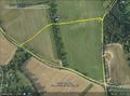
Google Earth Tracklog
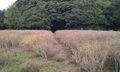
Oil Seed Rape
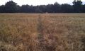
Stunted Barley
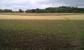
Doomed Sweetcorn at the Hashpoint


Other geohashing expeditions on the same day
Expeditions and Plans
| 2011-07-04 | ||
|---|---|---|
| Wanganui, New Zealand | Greenslime | About 25 m from roadside off SH49, close to Waiouru Military Camp |
| Crestview, Florida | Liberian, A non | A few tens of feet west of the very end of FIM Boulevard in Fort Walton Bea... |
| Newark, New Jersey | Jevanyn | A field on Township Line Rd. in Hillsborough, Somerset County, NJ. |
| Portland, Oregon | Michael5000 | A house at SE 14th and Malden, in Sellwood. |
| Mannheim, Germany | ilpadre | In Schriesheim, about 9 km north of Heidelberg. Next to a street and hopefu... |
| Norwich, United Kingdom | Sourcerer | On the south bank of the river Waveney east of Beccles, Suffolk, UK. |
| Rovaniemi, Finland | isopekka | About 5 km to the SE from my home, in Paavalniemi, on the wet shore of the ... |