Difference between revisions of "2012-09-28 -36 174"
imported>JimmyNZ m (Added blurb) |
imported>JimmyNZ m (blurb complete with pics and gif ;)) |
||
| Line 28: | Line 28: | ||
And of course, proof is in the pudding below. | And of course, proof is in the pudding below. | ||
| − | |||
| − | |||
| − | |||
== Photos == | == Photos == | ||
| Line 37: | Line 34: | ||
--> | --> | ||
<gallery perrow="5"> | <gallery perrow="5"> | ||
| + | |||
| + | File:2012-09-28_-36_174_co_ords_reached.JPG | Bang on the money | ||
| + | File:2012-09-28_-36_174_view_from_hash.gif | And in the middle of know-where | ||
| + | File:2012-09-28_-36_174_view_north.JPG | Nothing to my right | ||
| + | File:2012-09-28_-36_174_view_south.JPG | Nothing to my left | ||
| + | |||
</gallery> | </gallery> | ||
| − | + | ||
| − | + | ||
| − | |||
[[Category:Expedition planning]] | [[Category:Expedition planning]] | ||
| − | + | ||
[[Category:Expeditions]] | [[Category:Expeditions]] | ||
| − | + | ||
[[Category:Expeditions with photos]] | [[Category:Expeditions with photos]] | ||
| − | + | ||
| − | + | ||
| − | |||
| − | |||
| − | |||
[[Category:Coordinates reached]] | [[Category:Coordinates reached]] | ||
| − | |||
| − | |||
| − | |||
| − | |||
| − | |||
| − | |||
| − | |||
| − | |||
| − | |||
| − | |||
| − | |||
| − | |||
| − | |||
| − | |||
| − | |||
| − | |||
| − | |||
| − | |||
Revision as of 08:18, 28 September 2012
| Fri 28 Sep 2012 in -36,174: -36.7978383, 174.4112076 geohashing.info google osm bing/os kml crox |
Location
Beachside, Muriwai Beach, Auckland
Participants
Plans
Muriwai is the closest beach to our home location, so we were rather happy to see the hash fall here, rather than in the dense forestry block the runs alongside. After work, the plan is to drive to the beach and take a short jog north to the location - shouldn't be more than a 4 km return run.
Expedition
OK, so maybe not quite a walk on the beach, but pretty near. After re-examining the map in the afternoon it turned out to be an easier run (physically) along a gravel road (mentally boring as hell). So despite the drizzle and very gray skies we drove down the road for 25 minutes, parked up near an access road into the forestry block, one of many neighboring Muriwi, donned our running gear and trotted off.
We got stopped by a family out walking the dogs and toddlers who asked us how far we were going. Felt bad saying only five kilometers, even more when the guy misheard me and he 'what 25?'. Never mind, we'll just call this a mild leg stretcher.
Anyway after jogging around for a bit, Greenslime indicated we should pull off into the middle of know-where and approach a line of old warped pines. Usually we both end up doing the funky gps dance (see our last hash for the gif proof) but today Greenslime nailed it straight off the bat (after re-calibrating her gps).
So pictures taken and what i was hoping to be a nice sunny (make everyone in the world jealous) panaromic of the beach turned out to be a sad rather amatur take of the blair witch forest. But behind the dunes, i promise its a beauty.
Anyway, it got cold, we got hungry so we somehow managed to motivate ourselves to jog back to the car (straight gravel roads are very very boring to run on).
And of course, proof is in the pudding below.
Photos
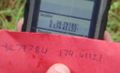
Bang on the money
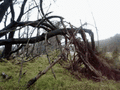
And in the middle of know-where
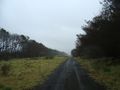
Nothing to my right
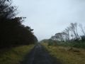
Nothing to my left


