Difference between revisions of "2015-02-19 52 1"
From Geohashing
imported>Sourcerer m (→Added graticule name) |
imported>Sourcerer m (→Achievements) |
||
| Line 32: | Line 32: | ||
== Achievements == | == Achievements == | ||
{{#vardefine:ribbonwidth|800px}} | {{#vardefine:ribbonwidth|800px}} | ||
| + | |||
| + | {{Two to the N achievement | ||
| + | | count = 7 | ||
| + | | date = 2015-02-19 | ||
| + | | latitude = 52 | ||
| + | | longitude = 1 | ||
| + | | name = [[Norwich,_United_Kingdom|The Norwich graticule]] | ||
| + | }} | ||
{{Sourcerer_links | {{Sourcerer_links | ||
Revision as of 16:18, 3 January 2016
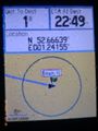
| Thu 19 Feb 2015 in Norwich, UK: 52.6663883, 1.2415479 geohashing.info google osm bing/os kml crox |
Location
In a field accessed via a public footpath, south east of Drayton, Norfolk, UK.
Participants
Expedition
First of two spanning midnight: 2015-02-19 52 1 :: 2015-02-20 52 0
- Arrived. -- Sourcerer (talk) @52.6664,1.2416 22:50, 19 February 2015 (GMT)
There was a convenient parking place. It was raining. The public footpath was across the road from the car park. This led into a meadow. The final field was accessed by climbing over a low rabbit fence. There were many rabbit holes but no rabbits. They were keeping dry, underground. The hashpoint field looked as though sweet-corn had been grown last year. There were some tough stalks. There is a damp looking evidence photo.
Photos
Proof
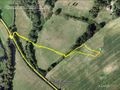
Track Log


Achievements

The Norwich graticule earned the Two to the N achievement
by attempting to reach 27 hashpoints on 2015-02-19 52 1 and is promoted to Level 7 (Expeditions).
Expeditions and Plans
| 2015-02-19 | ||
|---|---|---|
| Newark, New Jersey | Someone went | On the side of Henderson Rd., in Franklin Park. |
| Portland, Oregon | Jim | In front of an Oregon City house in a subdivision |
| Mannheim, Germany | DODO | A field between Mörstadt and Gundheim |
| Norwich, United Kingdom | Sourcerer | In a field accessed via a public footpath, south east of Drayton, Norfolk, ... |
Sourcerer's Expedition Links
2015-02-18 52 0 - 2015-02-19 52 1 - 2015-02-20 52 0 - KML file download of Sourcerer's expeditions for use with Google Earth.