Difference between revisions of "2015-08-21 51 0"
From Geohashing
imported>Sourcerer m (→New expedition) |
imported>Sourcerer m (→Photos) |
||
| Line 28: | Line 28: | ||
<gallery perrow="5"> | <gallery perrow="5"> | ||
Image:2015-08-21_51_0_Sourcerer_1440154951260.jpg | Proof [http://www.openstreetmap.org/?lat=51.94151938&lon=.83709061&zoom=16&layers=B000FTF @51.9415,.8371] | Image:2015-08-21_51_0_Sourcerer_1440154951260.jpg | Proof [http://www.openstreetmap.org/?lat=51.94151938&lon=.83709061&zoom=16&layers=B000FTF @51.9415,.8371] | ||
| − | Image: | + | Image:2015-08-21 51 0 Sourcerer.jpg | Track in Google Earth |
</gallery> | </gallery> | ||
Revision as of 13:33, 21 August 2015
| Fri 21 Aug 2015 in 51,0: 51.9415095, 0.8371010 geohashing.info google osm bing/os kml crox |
Location
In a harvested field between Fordham and Little Horkesley, Essex, UK.
Participants
Plans
I went on impulse as I was quite close.
Expedition
- Arrived. -- Sourcerer (talk) @51.9415,.8371 12:04, 21 August 2015 (GMT+01:00)
I had been delivering a guitar, a violin, a viola and a didgeridoo to Rob, a school teacher friend, in the hope that the instruments might get restored, find homes and get used. This was in south Suffolk. From there, north Essex was not much further and as usual this month, my local hashpoint was in the sea. So I visited London East. The point was in a harvested field 45 metres from the field access where I could park. Easy!
Photos
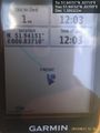
Proof @51.9415,.8371
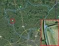
Track in Google Earth


Achievements
Expeditions and Plans
| 2015-08-21 | ||
|---|---|---|
| London East, United Kingdom | Sourcerer | 1) In a harvested field between Fordham and Little Horkesley, Essex, UK. |
| Cambridge, United Kingdom | Sourcerer | 2) A field perimeter hashpoint north of Golden Gates, Holkham Hall, Norfolk... |
Sourcerer's Expedition Links
2015-08-19 52 1 - 2015-08-21 51 0 - 2015-08-21 52 0 - KML file download of Sourcerer's expeditions for use with Google Earth.