Difference between revisions of "2015-10-29 52 0"
From Geohashing
imported>Sourcerer m (→Expedition) |
imported>Sourcerer m (→Added achievement) |
||
| Line 32: | Line 32: | ||
== Achievements == | == Achievements == | ||
{{#vardefine:ribbonwidth|700px}} | {{#vardefine:ribbonwidth|700px}} | ||
| + | |||
| + | {{Last man standing | ||
| + | | latitude = 52 | ||
| + | | longitude = 0 | ||
| + | | date = 2015-10-29 | ||
| + | | gender = man | ||
| + | | name = Sourcerer | ||
| + | }} | ||
{{Sourcerer_links | {{Sourcerer_links | ||
Revision as of 15:52, 6 November 2015
| Thu 29 Oct 2015 in 52,0: 52.9432557, 0.8480630 geohashing.info google osm bing/os kml crox |
Location
In a field south of Wells next the Sea, Norfolk, UK. A public footpath runs along the perimeter of this field.
Participants
Plans
Expedition one of two spanning midnight - 2015-10-29 52 0 - 2015-10-30 52 1 - ETA 22:40.
Expedition
- Arrived. -- Sourcerer (talk) @52.9433,.8481 22:34, 29 October 2015 (GMT)
This was routine. Park at the start of the public footpath. Walk to the correct field. Find a way in. Locate suitable tractor tracks. Walk to the hashpoint avoiding the oil seed rape plants. It was overcast with very light drizzle, not enough to need an umbrella, with a mild 14 C temperature.
Photos
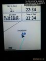
Proof @52.9433,.8481
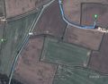
Track in Google Earth


Achievements
Sourcerer earned the Last man standing achievement
|
Expeditions and Plans
| 2015-10-29 | ||
|---|---|---|
| Cambridge, United Kingdom | Sourcerer | In a field south of Wells next the Sea, Norfolk, UK. A public footpath runs... |
Sourcerer's Expedition Links
2015-10-28 52 1 - 2015-10-29 52 0 - 2015-10-30 52 1 - KML file download of Sourcerer's expeditions for use with Google Earth.