Difference between revisions of "2017-03-07 52 1"
From Geohashing
imported>Sourcerer m (→New expedition) |
imported>Sourcerer m (→Fixed a link) |
||
| Line 35: | Line 35: | ||
| prev = 2017-03-05 52 1 | | prev = 2017-03-05 52 1 | ||
| curr = 2017-03-07 52 1 | | curr = 2017-03-07 52 1 | ||
| − | | next = 2017-03- | + | | next = 2017-03-15 52 1 |
| date = 2017-03-07 | | date = 2017-03-07 | ||
}} | }} | ||
Revision as of 00:49, 16 March 2017
| Tue 7 Mar 2017 in Norwich, UK: 52.1460008, 1.4729943 geohashing.info google osm bing/os kml crox |
Location
A field by Tunstall Forest, Suffolk, UK.
Participants
Plans
The Wednesday point could have been paired with this one but sadly it's on a live military airfield.
Expedition
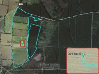
There are many paths in this forest, some made by deer. One led close to the hashpoint and it could be reached by crossing stubble from the crop last autumn. The walk was about 5 km with only 200 metres diversion to the hashpoint.
Photos
- Gallery
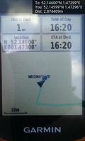
Arrived. @52.1460,1.4730
Achievements
Expeditions and Plans
| 2017-03-07 | ||
|---|---|---|
| Norwich, United Kingdom | Sourcerer | A field by Tunstall Forest, Suffolk, UK. |
Sourcerer's Expedition Links
2017-03-05 52 1 - 2017-03-07 52 1 - 2017-03-15 52 1 - KML file download of Sourcerer's expeditions for use with Google Earth.

