Difference between revisions of "Tooele, Utah"
From Geohashing
(→Notable Events) |
imported>Jiml m (Remove stray category) |
||
| Line 20: | Line 20: | ||
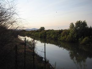
*[[2008-06-14]] [[User:Robyn|Robyn]] got within a mile of the hash, in a small lake north west of the airport, but a wide ditch named Goggin Drain barred the way. [[Image:2008-06-14_40_-112.JPG|thumb|Goggin Drain]] | *[[2008-06-14]] [[User:Robyn|Robyn]] got within a mile of the hash, in a small lake north west of the airport, but a wide ditch named Goggin Drain barred the way. [[Image:2008-06-14_40_-112.JPG|thumb|Goggin Drain]] | ||
*[[2008-07-09 40 -112]] [[User:xaco|xaco]] made it to the hash near Copper Hills High School. | *[[2008-07-09 40 -112]] [[User:xaco|xaco]] made it to the hash near Copper Hills High School. | ||
| − | *[[2009-11-11 40 -112]] [[User:Geohashgirl|Geohashgirl]] did NOT make it to the hash on [[ | + | *[[2009-11-11 40 -112]] [[User:Geohashgirl|Geohashgirl]] did NOT make it to the hash on [[2009-11-11]] because of Camp Williams. |
== Local Geohashers == | == Local Geohashers == | ||
Revision as of 21:17, 12 November 2009
| Park Valley | Clearfield | Ogden |
| Bonneville Salt Flats | Tooele | Salt Lake City |
| Fish Springs | Delta | Nephi |
|
Today's location: geohashing.info google osm bing/os kml crox | ||
The Tooele, Utah graticule is at latitude 40, longitude -112.
Activities
Notable Events
- 2008-06-14 Robyn got within a mile of the hash, in a small lake north west of the airport, but a wide ditch named Goggin Drain barred the way.
- 2008-07-09 40 -112 xaco made it to the hash near Copper Hills High School.
- 2009-11-11 40 -112 Geohashgirl did NOT make it to the hash on 2009-11-11 because of Camp Williams.
Local Geohashers
- xaco's brother lives in this graticule, so he occasionally ends up around here.
