Difference between revisions of "Raleigh, North Carolina"
From Geohashing
imported>Mattbman |
|||
| Line 1: | Line 1: | ||
{{graticule | {{graticule | ||
|map = <map lat="35" lon="-78" /> | |map = <map lat="35" lon="-78" /> | ||
| − | |nw = [[Danville]] | + | |nw = [[Danville, Virginia]] |
| − | |n = [[ | + | |n = [[Henderson, North Carolina]] |
| − | |ne = [[Roanoke Rapids]] | + | |ne = [[Roanoke Rapids, North Carolina]] |
| − | |w = [[Chapel Hill | + | |w = [[Chapel Hill, North Carolina]] |
| − | |e = [[Greenville, | + | |e = [[Greenville, North Carolina]] |
| − | |sw = [[Florence]] | + | |sw = [[Florence, South Carolina]] |
| − | |s = [[Elizabethtown]] | + | |s = [[Elizabethtown, North Carolina]] |
| − | |se = [[Wilmington, | + | |se = [[Wilmington, North Carolina]] |
}} | }} | ||
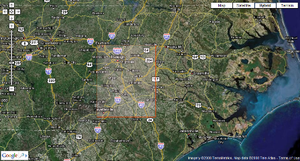
[[Image:Raleigh_Graticule_Thumb.png|thumb|300 px|The Raleigh Graticule]] | [[Image:Raleigh_Graticule_Thumb.png|thumb|300 px|The Raleigh Graticule]] | ||
| − | The Raleigh [[graticule]] is at latitude 35, longitude -78 | + | The Raleigh [[graticule]] is at latitude 35, longitude -78 and included most of the counties of Wake and Johnston, as well as parts of Durham, Nash, and Cumberland counties (among others). The border to the north runs near Route 98. The border to the East follows near Route 117. The southern border runs near Route 24. |
| + | |||
| + | Cities completely included in the Raleigh Graticule: Raleigh, Knightdale, Wendell, Zebulon, Cary, Apex, Garner, Clayton, Fuquay-Varina, Lillington, Coats, Benson, Smithfield, Selma, Kenly, Mt. Olive, Newton Grove, Dunn, Wade, and Spring Hope. | ||
| + | |||
| + | Cities partially included in the Raleigh Graticule: Wake Forest, Durham, Fayetteville, Goldsboro. | ||
== Activities == | == Activities == | ||
Revision as of 19:57, 27 May 2008
[[Category:Meetup in {{{lat}}} {{{lon}}}| ]]
The Raleigh graticule is at latitude 35, longitude -78 and included most of the counties of Wake and Johnston, as well as parts of Durham, Nash, and Cumberland counties (among others). The border to the north runs near Route 98. The border to the East follows near Route 117. The southern border runs near Route 24.
Cities completely included in the Raleigh Graticule: Raleigh, Knightdale, Wendell, Zebulon, Cary, Apex, Garner, Clayton, Fuquay-Varina, Lillington, Coats, Benson, Smithfield, Selma, Kenly, Mt. Olive, Newton Grove, Dunn, Wade, and Spring Hope.
Cities partially included in the Raleigh Graticule: Wake Forest, Durham, Fayetteville, Goldsboro.
Activities
Notable Events
Local Geohashers
- ZachCox
- Caroline will be geohashing at the beginning of summer.
- Chris is gonna try this on his off weekends from work.
- Mary might geohash this summer. She thinks its terribly clever.
- WokTiny is in Raleigh about one weekend a month, looks forward to it.
- Morgan thinks this is very exciting, and will go next time it's close to Chapel Hill.
- Tyler lives in Raleigh and may defect to another graticule if it's closer.
- Nick is living in Apex and plans to Geo-hash whenever he can.
- Emmaus will be back in Raleigh in the fall.
- Ben thinks we might also want to take into consideration the other three graticules that fall close to Chapel Hill, Durham and Hillsborough, especially when the point falls in the east or south. (He is perhaps biased due to starting from Hillsborough.)
- Chad is in Chapel Hill, and will keep an eye out for options in the surrounding gratiules.
- Jordan thinks we should try to get a spontaneous meet up going the next Saturday that the point is somewhere near Raleigh
- Matt is in North Raleigh, might be able to do this on Saturday or Sunday, probably look at the Graticules to the North, West, and North West if the dot is too far out of town.
