Difference between revisions of "2022-04-06 45 -121"
Michael5000 (talk | contribs) |
m (subst-ing) |
||
| Line 8: | Line 8: | ||
And DON'T FORGET to add your expedition and the best photo you took to the gallery on the Main Page! We'd love to read your report, but that means we first have to discover it! :) | And DON'T FORGET to add your expedition and the best photo you took to the gallery on the Main Page! We'd love to read your report, but that means we first have to discover it! :) | ||
-->{{meetup graticule | -->{{meetup graticule | ||
| − | | lat= | + | | lat=45 |
| − | | lon= | + | | lon=-121 |
| − | | date= | + | | date=2022-04-06 |
}}<!-- edit as necessary --> | }}<!-- edit as necessary --> | ||
__NOTOC__ | __NOTOC__ | ||
Latest revision as of 20:46, 24 May 2024
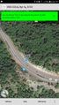
| Wed 6 Apr 2022 in 45,-121: 45.3070049, -121.8303935 geohashing.info google osm bing/os kml crox |
Location
On the side of U.S. 26, between Rhododendron and Government Camp.
Participants
Expedition
Having taken a pass on the chance to wander through a car lot in Gladstone yesterday, I thought I would probably take a pass on the chance to drive for an hour to stand on the side of a highway, too. But as the workday wore on, the idea of a drive in the country started to sound pretty good.
It was a clear spring day, and there were lots of great views of Mount Hood on the way out. A generous pull-out across the road from the hashpoint made it pretty easy to park safely. I crossed the highway, stood on the hashpoint, looked around a bit, and then went home.
Photos
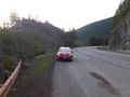
Parking Mrs.5000's car by the roadside.
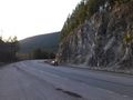
Somebody drives past the hashpoint.
I made it!

I celebrate another triumph.
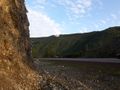
Looking back towards the car from ground zero.


Achievements
My first expedition to the (45,-121) section of Clackamas County.
