Difference between revisions of "2019-08-03 45 -119"
From Geohashing
Michael5000 (talk | contribs) |
Michael5000 (talk | contribs) |
||
| Line 1: | Line 1: | ||
| − | |||
| − | |||
[[Image:2019-08-03 45 -119 barrel.jpg|thumb|left]] | [[Image:2019-08-03 45 -119 barrel.jpg|thumb|left]] | ||
| − | |||
{{meetup graticule | {{meetup graticule | ||
| lat=45 | | lat=45 | ||
Revision as of 16:35, 2 May 2023
| Sat 3 Aug 2019 in 45,-119: 45.1760465, -119.1228009 geohashing.info google osm bing/os kml crox |
Location
In National Forest land, not far off the road from Ukiah to Heppner.
Participants
- Michael5000: Expedition #222
Expedition
So, from 2019-08-03 45 -118 I wound my way out of the woods, back through LaGrande, and then up the highway to Ukiah, where my family lived for a memorably challenging year before I was born. They are still talking about it.
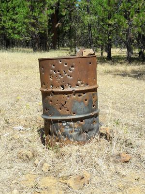
A well-maintained, paved, striped forest road goes through the Blue Mountains from Ukiah to Heppner, so getting to this hashpoint required no more than parking off of a side road and walking across a meadow. The shot-up barrel was around 100 feet from the hashpoint. I took my pictures, then continued on to Heppner, and from there pointed the prow back towards Portland and home. In The Dalles, I finally caught up with those enchiladas.
Photos
Achievements
Michael5000 earned the Multihash Achievement
|


