Difference between revisions of "2023-10-07 43 -121"
Michael5000 (talk | contribs) (→Photos) |
m (subst-ing) |
||
| Line 8: | Line 8: | ||
And DON'T FORGET to add your expedition and the best photo you took to the gallery on the Main Page! We'd love to read your report, but that means we first have to discover it! :) | And DON'T FORGET to add your expedition and the best photo you took to the gallery on the Main Page! We'd love to read your report, but that means we first have to discover it! :) | ||
-->{{meetup graticule | -->{{meetup graticule | ||
| − | | lat= | + | | lat=43 |
| − | | lon= | + | | lon=-121 |
| − | | date= | + | | date=2023-10-07 |
}}<!-- edit as necessary --> | }}<!-- edit as necessary --> | ||
== Location == | == Location == | ||
Latest revision as of 21:07, 24 May 2024
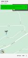
| Sat 7 Oct 2023 in 43,-121: 43.7412930, -121.6819150 geohashing.info google osm bing/os kml crox |
Location
West of La Pine in the Deschutes National Forest.
Participants
Expedition
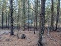
On a business/adventuring expedition, I woke up early in Bend and (after a quick stop for a bag of bagels) headed south on US 97 for a ways, and then southwest on well-paved Century Drive for another 14 miles or so. That got me to Forest Road 4258 and then immediately to 4258-100, which was really the first opportunity for the still new expedition vehicle to show its stuff in marginal-roads geohashing. I parked within a few hundred meters of the hashpoint, and from there it was just an easy (but cold!) dawn walk through the open forest of Central Oregon.
Photos

Base Camp: Bend
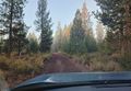
a marginal road
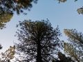
Looking up the tree that lives at the hashpoint
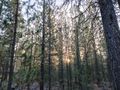
Sunrise through the forest

Me
Finding the vehicle again
Yay!


Achievements
- My second successful expedition to the La Pine graticule (after a 12-year lapse).
- My second successful expedition to Deschutes County (after a 5-month lapse).