Difference between revisions of "2010-01-31 45 -122"
From Geohashing
imported>Jiml m (Picture pointers) |
imported>Jiml (Add pictures) |
||
| Line 5: | Line 5: | ||
}} | }} | ||
| − | |||
__NOTOC__ | __NOTOC__ | ||
== Location == | == Location == | ||
| Line 16: | Line 15: | ||
== Plans == | == Plans == | ||
| − | + | Plans weren't very firm. | |
I'll make the trip if I don't make an attempt on the previous day's point, and might even try this one if I do. --[[User:Aperfectring|aperfectring]] 21:17, 29 January 2010 (UTC) | I'll make the trip if I don't make an attempt on the previous day's point, and might even try this one if I do. --[[User:Aperfectring|aperfectring]] 21:17, 29 January 2010 (UTC) | ||
| + | |||
| + | Jim decided to head there, however. APR wasn't up to it. | ||
| Line 33: | Line 34: | ||
* Holy Hash? | * Holy Hash? | ||
| − | |||
== Photos == | == Photos == | ||
| − | |||
<gallery perrow="4"> | <gallery perrow="4"> | ||
Image:2010-01-31_45_-122-church5.jpg | The nearby church | Image:2010-01-31_45_-122-church5.jpg | The nearby church | ||
| + | Image:2010-01-31_45_-122-grave2.jpg | The nearby graveyard | ||
| + | Image:2010-01-31_45_-122-hashpt1.jpg | A view of the area around the hashpoint | ||
| + | Image:2010-01-31_45_-122-gps2.jpg | The GPS at the hashpoint | ||
</gallery> | </gallery> | ||
| − | |||
| − | |||
| − | |||
| − | |||
| − | |||
| − | |||
| − | |||
| − | |||
| − | |||
| − | |||
| − | |||
| − | |||
| − | |||
| − | |||
| − | |||
| − | |||
| − | |||
| − | |||
| − | |||
[[Category:Coordinates reached]][[Category:Expeditions]][[Category:Expeditions with photos]] | [[Category:Coordinates reached]][[Category:Expeditions]][[Category:Expeditions with photos]] | ||
Revision as of 03:08, 3 February 2010
| Sun 31 Jan 2010 in 45,-122: 45.3697908, -122.8551778 geohashing.info google osm bing/os kml crox |
Location
Sherwood, Oregon, Near St Paul's on Roy Rogers Road.
Participants
Plans
Plans weren't very firm.
I'll make the trip if I don't make an attempt on the previous day's point, and might even try this one if I do. --aperfectring 21:17, 29 January 2010 (UTC)
Jim decided to head there, however. APR wasn't up to it.
Expedition
More full report to follow, but the point was very accessible. I asked a teacher at the school for access to the field and was granted permission.
Point was reached.
Achievements
- Land Geohash
- Consecutive Geohashes
- Holy Hash?
Photos
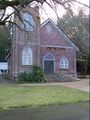
The nearby church
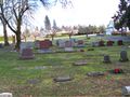
The nearby graveyard
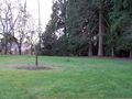
A view of the area around the hashpoint
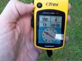
The GPS at the hashpoint


