Difference between revisions of "2010-11-04 -36 174"
From Geohashing
imported>Greenslime m |
imported>Greenslime m |
||
| Line 25: | Line 25: | ||
== Photos == | == Photos == | ||
<gallery perrow="5"> | <gallery perrow="5"> | ||
| + | 2010-11-04_-36_174_To_the_hash.jpg|The approach | ||
| + | File:2010-11-04_-36_174_View2.jpg|View from the hash | ||
File:2010-11-04 -36 174 Me.jpg|Me | File:2010-11-04 -36 174 Me.jpg|Me | ||
File:2010-11-04_-36_174_proof.jpg|Proof | File:2010-11-04_-36_174_proof.jpg|Proof | ||
Revision as of 04:09, 4 November 2010
| Thu 4 Nov 2010 in -36,174: -36.7745109, 174.6169430 geohashing.info google osm bing/os kml crox |
Location
Edge of an estuary, Whenuapai, Auckland
Participants
- Greenslime
- JimmyNZ's very pissed off spirit
Plans
Oh no, JimmyNZ's turf again. This hash is highly likely in, or on the edge of a mangrove swamp which is near impossible... Well, there are degrees of impossible, depends on how exciting one wants to make it. Will scope it out this evening, will take old shoes
Expedition
Tracklog
Photos
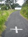
The approach
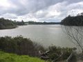
View from the hash

Me

Proof
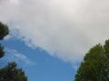
Sky divers
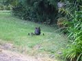
Aww


