Difference between revisions of "2012-03-19 52 1"
From Geohashing
imported>Sourcerer ([live] Arrived.) |
imported>Sourcerer |
||
| Line 1: | Line 1: | ||
| − | |||
| − | |||
| − | |||
| − | |||
| − | |||
| − | |||
| − | |||
| − | |||
| − | |||
| − | |||
{{meetup graticule | {{meetup graticule | ||
| − | | lat=52 | + | | lat=52 |
| − | | lon=1 | + | | lon=1 |
| − | | date=2012-03-19 | + | | date=2012-03-19 |
| + | | graticule_name=Norwich | ||
| + | | graticule_link=Norwich, United Kingdom | ||
}} | }} | ||
| − | |||
| − | |||
== Location == | == Location == | ||
| − | + | ||
| + | Just outside a house on Aldwyck Way between Carlton Colville and Lowestoft. | ||
== Participants == | == Participants == | ||
| − | |||
| − | + | [[User:Sourcerer|Sourcerer]] | |
| − | |||
== Expedition == | == Expedition == | ||
| − | |||
| + | *Arrived. -- [[User:Sourcerer|Sourcerer]] [http://www.openstreetmap.org/?lat=52.455623745918274&lon=1.7160183191299438&zoom=16&layers=B000FTF @52.4556,1.7160] 16:49, 19 March 2012 (GMT) | ||
| − | + | This was a very easy expedition. An alternative route on my drive home took me right to the hashpoint. It was a wonderful sunny spring evening with blackthorn and gorse in bloom and children trapped indoors for the winter months were outside playing. | |
| − | |||
| − | |||
== Photos == | == Photos == | ||
| − | + | ||
| − | |||
| − | |||
<gallery perrow="5"> | <gallery perrow="5"> | ||
| + | Image:2012-03-19 52 1 Sourcerer 1.jpg | The hashpoint was on Google Streetview. | ||
| + | Image:2012-03-19 52 1 Sourcerer 2.jpg | My photo of the hashpoint. | ||
| + | Image:2012-03-19 52 1 Sourcerer 3.jpg | The satnag evidence. | ||
</gallery> | </gallery> | ||
| − | == | + | == Other geohashing expeditions on the same day == |
| − | |||
| − | |||
| + | {{expedition summaries|2012-03-19}} | ||
| − | + | [[Category:Meetup on 2012-03-19]] | |
| − | + | [[Category:Meetup in 52 1]] | |
| − | [[Category: | ||
| − | |||
| − | |||
| − | |||
| − | [[Category: | ||
| − | |||
| − | |||
| − | |||
[[Category:Expeditions]] | [[Category:Expeditions]] | ||
| − | |||
[[Category:Expeditions with photos]] | [[Category:Expeditions with photos]] | ||
| − | |||
| − | |||
| − | |||
| − | |||
| − | |||
[[Category:Coordinates reached]] | [[Category:Coordinates reached]] | ||
| − | |||
| − | |||
| − | |||
| − | |||
| − | |||
| − | |||
| − | |||
| − | |||
| − | |||
| − | |||
Revision as of 19:05, 19 March 2012
| Mon 19 Mar 2012 in Norwich: 52.4556227, 1.7159722 geohashing.info google osm bing/os kml crox |
Contents
Location
Just outside a house on Aldwyck Way between Carlton Colville and Lowestoft.
Participants
Expedition
- Arrived. -- Sourcerer @52.4556,1.7160 16:49, 19 March 2012 (GMT)
This was a very easy expedition. An alternative route on my drive home took me right to the hashpoint. It was a wonderful sunny spring evening with blackthorn and gorse in bloom and children trapped indoors for the winter months were outside playing.
Photos
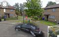
The hashpoint was on Google Streetview.
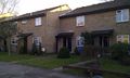
My photo of the hashpoint.
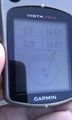
The satnag evidence.


Other geohashing expeditions on the same day
Expeditions and Plans
| 2012-03-19 | ||
|---|---|---|
| Houston, Texas | Someone went | I'm guessing that nobody actually attempted this? If so, perhaps we shoul... |
| Roswell, Georgia | NWoodruff | On a wooded lot of an abandoned subdivision in Paulding County |
| Kenosha, Wisconsin | Haberdasher, Peacemaker, Haberdasher's friend | inside a commercial building in an industrial park in Niles. |
| Mannheim, Germany | Danatar | in the forest on the Weißer Stein mountain near Heidelberg. Country: Germa... |
| Norwich, United Kingdom | Sourcerer | Just outside a house on Aldwyck Way between Carlton Colville and Lowestoft.... |
| Manchester, United Kingdom | User:Angel | Waine Street, St Helens. |
| Uppsala, Sweden | zeot | Some kind of field in Kungsängen. |