Difference between revisions of "2012-08-10 56 -3"
From Geohashing
imported>Sourcerer |
imported>Sourcerer |
||
| Line 37: | Line 37: | ||
[[Category:Expeditions with photos]] | [[Category:Expeditions with photos]] | ||
[[Category:Coordinates reached]] | [[Category:Coordinates reached]] | ||
| − | |||
| − | |||
| − | |||
| − | |||
| − | |||
| − | |||
| − | |||
| − | |||
| − | |||
| − | |||
| − | |||
| − | |||
| − | |||
| − | |||
| − | |||
| − | |||
| − | |||
| − | |||
| − | |||
| − | |||
| − | |||
| − | |||
| − | |||
| − | |||
| − | |||
| − | |||
| − | |||
| − | |||
| − | |||
| − | |||
| − | |||
| − | |||
| − | |||
| − | |||
| − | |||
| − | |||
| − | |||
| − | |||
| − | |||
| − | |||
| − | |||
| − | |||
| − | |||
| − | |||
| − | |||
| − | |||
| − | |||
| − | |||
| − | |||
| − | |||
| − | |||
| − | |||
| − | |||
| − | |||
| − | |||
Revision as of 08:28, 11 August 2012
| Thu 9 Aug 2012 in Perth: 56.3125551, -3.6909587 geohashing.info google osm bing/os kml crox |
Contents
Location
Just south of the A907, west of Dunfirmline, Scotland, UK.
Participants
Expedition
- Arrived. -- Sourcerer @56.0666,-3.6328 10:06, 10 August 2012 (GMT+01:00)
This was not my favourite kind of expedition. Drive on busy roads for ages to stand in a damp wheat field. I would not have bothered except this was a new graticule and I night never get to Scotland again in my lifetime. It's 1000 km away so not really ideal for a day trip. I'm in Scotland for the wedding of some good friends and making the best of the few days I'm staying.
Photos
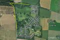
Google Earth Overview
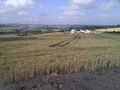
The Terrain


Other geohashing expeditions on the same day
Expeditions and Plans
| 2012-08-09 | ||
|---|---|---|
| Atlanta, Georgia | NWoodruff | In a well over grown lot in Vinings. |
| Youngstown, Ohio | User:Fezzic181 | Found the spot out in the middle of the state game lands. |
| Billings, Montana | Rory | Lake Elmo State Park north of Billings, MT. The actual hash point is in th... |
| Northampton, United Kingdom | Sourcerer | 2) On an urban public path through attractive lawns and trees in Wellingbor... |
| Birmingham, United Kingdom | Sourcerer | 3) A few metres off a public footpath in a hay field. This was near the Gra... |
| Cambridge, United Kingdom | Sourcerer | 1) Sourcerer failed to reach the hashpoint in a very muddy pig field. |
| Amsterdam, Netherlands | Marvyn | Behind a container-like building in some shrubs in an urban area in Hoofddo... |
| Manchester, United Kingdom | Sourcerer | 4) Close to junction 12 on the M56. The hashpoint was on or very close to t... |
| Dundee, United Kingdom | Sourcerer | 5) Beside the coast road east of St. Andrews, Fife, Scotland, UK. |