Difference between revisions of "2012-08-19 52 0"
imported>Benjw m (cats for successful hash; write-up to follow) |
imported>Benjw (header photo, gallery & multihash nav) |
||
| Line 1: | Line 1: | ||
| − | + | [[Image:{{{image|2012-08-19 52 0 poppies.jpg}}}|thumb|left]] | |
{{meetup graticule | {{meetup graticule | ||
| lat=52 | | lat=52 | ||
| Line 11: | Line 11: | ||
* [[User:Benjw|Benjw]] | * [[User:Benjw|Benjw]] | ||
* [[User:Ali0sha|Ali0sha]] | * [[User:Ali0sha|Ali0sha]] | ||
| + | |||
| + | {{:User:Benjw/multihash|2012-08-19 52 -0|2012-08-19 52 0}} | ||
== Plans == | == Plans == | ||
| Line 18: | Line 20: | ||
== Expedition == | == Expedition == | ||
| − | + | ||
== Photos == | == Photos == | ||
| − | < | + | <gallery perrow="4"> |
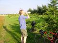
| − | + | Image:2012-08-19 52 0 edge of field.jpg | Parking the bikes against some convenient trees | |
| − | Image: | + | Image:2012-08-19 52 0 refreshment.jpg | Taking the opportunity of some refreshment |
| + | Image:2012-08-19 52 0 ben at hashpoint.jpg | Benjw at the hashpoint | ||
| + | Image:2012-08-19 52 0 ali0sha at hashpoint.jpg | Ali0sha at the hashpoint | ||
| + | Image:2012-08-19 52 0 gps proof.jpg | Proof of hash, if you can read it | ||
| + | Image:2012-08-19 52 0 poppies.jpg | Poppies growing amongst the crops | ||
</gallery> | </gallery> | ||
| − | |||
== Achievements == | == Achievements == | ||
| Line 32: | Line 37: | ||
[[Category:Expeditions]] | [[Category:Expeditions]] | ||
| − | + | [[Category:Expeditions with photos]] | |
[[Category:Coordinates reached]] | [[Category:Coordinates reached]] | ||
Revision as of 16:28, 21 August 2012

| Sun 19 Aug 2012 in 52,0: 52.2624920, 0.0300963 geohashing.info google osm bing/os kml crox |
Location
In a field just off the main road between Bar Hill and Longstanton, a little northwest of Cambridge. The hash itself should be accessible if the field is not full of crops.
Participants
| This expedition was part of a multihash by Benjw. For the other parts, see: | |||||
|---|---|---|---|---|---|
| 2012-08-19 52 -0 | 2012-08-19 52 0 | ||||
Plans
Coincidentally, Ben will be driving up this very road the previous day to attend a friend's wedding in Longstanton village, so he will have a glance into the field to see if the crops are harvested and the hash will be accessible or not.
Assuming the hash is possible, Ben plans to cycle up from Cambridge in the late afternoon, once the temperature has dropped a bit (it's been 30 degrees this week). Probably route is up the guided busway from north Cambridge to Longstanton, then down the road to the hash. Then on to Bar Hill, and up the footpaths and bridleways through Lolworth to Boxworth, where the Northampton graticule hash also looks accessible.
Expedition
Photos

Parking the bikes against some convenient trees
Taking the opportunity of some refreshment
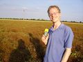
Benjw at the hashpoint
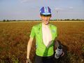
Ali0sha at the hashpoint
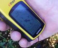
Proof of hash, if you can read it
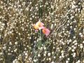
Poppies growing amongst the crops


