Difference between revisions of "2012-11-23 49 8"
imported>RecentlyChanged (→Expedition) |
imported>RecentlyChanged (→Achievements) |
||
| Line 59: | Line 59: | ||
== Achievements == | == Achievements == | ||
{{#vardefine:ribbonwidth|800px}} | {{#vardefine:ribbonwidth|800px}} | ||
| − | + | {{land geohash | latitude = 49 | longitude = 8 | date = 2012-11-23 | name = Deuded and RecentlyChanged}} | |
| + | {{Coffin potato | latitude = 49 | longitude = 8 | date = 2012-11-23 | deceased = Jllya Forshtat, Berta Melnichenko and Valentina Matsyuk | deathdate = 2005 | name = Deuded and RecentlyChanged}} | ||
| + | {{holy hash | latitude = 49 | longitude = 8 | date = 2012-11-23 | name = Deuded and RecentlyChanged | description = on a jewish graveyard}} | ||
| + | {{Public transport geohash | latitude = 49 | longitude = 8 | date = 2012-11-23 |busline = KVV| name = Deuded and RecentlyChanged }} | ||
| + | {{consecutive geohash | count = 2 | latitude = 49 | longitude = 8 | date = 2012-11-22 | name = Deuded and RecentlyChanged}} | ||
| + | {{Midnight geohash | latitude = 49 | longitude = 8 | date = 2012-11-22 | name = Deuded and RecentlyChanged}} | ||
| + | |||
| − | |||
| − | |||
[[Category:New report]] | [[Category:New report]] | ||
| − | |||
| − | |||
| − | |||
| − | |||
| − | |||
| − | |||
| − | |||
[[Category:Expeditions]] | [[Category:Expeditions]] | ||
| − | + | [[Category:Expeditions with photos]] | |
| − | [[Category:Expeditions with photos]] | ||
| − | |||
| − | |||
| − | |||
| − | |||
| − | |||
[[Category:Coordinates reached]] | [[Category:Coordinates reached]] | ||
| − | |||
| − | |||
| − | |||
| − | |||
| − | |||
| − | |||
| − | |||
| − | |||
| − | |||
| − | |||
| − | |||
| − | |||
| − | |||
| − | |||
| − | |||
| − | |||
| − | |||
| − | |||
Revision as of 16:04, 23 November 2012
| Fri 23 Nov 2012 in 49,8: 49.0147474, 8.4320110 geohashing.info google osm bing/os kml crox |
Location
On the main graveyard of Karlsruhe.
Participants
At the moment RecentlyChanged 17:02, 21 November 2012 (EST) and now Deuded too (06:26, 22 November 2012 (EST))
Plans
Going to the graveyard o.O
now plans have changed. We will go to the graveyard at midnight if possible.
Expedition
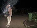
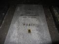
After drinking two beer and eating a little bit we made our way home to Deuded to take his camera and a thermometer (about 4°C near the Hash, forgot the proof). Then we walked to the next tram station at about 11:35 pm. Okay we ran, but it was senseless because the tram was late for about 5 minutes. From the tramstation we headed directly into the graveyard. Main gate closed, but smaller ones where open as we had hoped. Then we walked a little bit through the Graveyard but it seemed to be impossible to came more near than 75 meters. We searched a while for a way because there had to be one, on Gmaps we had seen that the Hash lays between graves. After a while we saw a little church behind the walls of the graveyard and we decided to go there. A gate blocked our way, after thinking about walking around or just climb over it (around was legal) RC tried to open it: "Hey it s open !"-:D-feeling. After we were on this separated yard, we thought it was an older or newer part of the main graveyard, the Hash was really easy to find. We took our proof and the proof for the coffin-potatoes. After the second picture we realized that the letters on the gravestones were partly hebrew. Until that we weren't aware that it was an Jewish graveyard. We took the last photos and walked straight back to the tramstation RC needed to come home.
This was a Geohashing night, wow!
Tracklog
http://www.everytrail.com/view_trip.php?trip_id=1892908
Photos
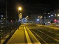
The tramstation we started

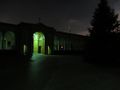
Entering the Main Graveyard
Just through
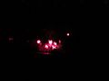
Trying to picture the red lamps, and the atmosphere they raised
This one dis doing a better job
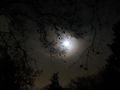
We have photo of a GHOST!!

Deuded trying to reproduce such a ghost :D
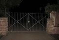
East this gate blocked our way north
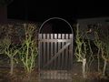
This one don't blocked us ;) (it was no no trespassing I hope, we just came from the wrong side)
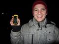
Proof for Deuded
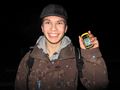
and RecentlyChanged
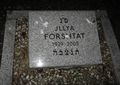
and for Jllya Forshtat
and for Berta Melnichenko
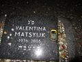
and at least for Valentina Matsyuk


Achievements
Deuded and RecentlyChanged earned the Land geohash achievement
|
Deuded and RecentlyChanged certifies that Jllya Forshtat, Berta Melnichenko and Valentina Matsyuk earned the Coffin Potato Achievement
|
Deuded and RecentlyChanged earned the Holy hash achievement
|
Deuded and RecentlyChanged earned the Public transport geohash achievement
|
Deuded and RecentlyChanged earned the Consecutive geohash achievement
|
Deuded and RecentlyChanged earned the Midnight Geohash achievement
|