Difference between revisions of "2013-05-06 47 6"
From Geohashing
imported>Crox (report, success!) |
imported>Crox m ("on", poster link) |
||
| Line 23: | Line 23: | ||
{{#vardefine:gaHeight|230}} | {{#vardefine:gaHeight|230}} | ||
{{Gallery2| | {{Gallery2| | ||
| − | {{GalleryItem | File:2013-05-06_47_6-00-plan.jpg | my notes how to get there. "le plan" is actually the first place to cross according to the Swisstopo map :o) }} | + | {{GalleryItem | File:2013-05-06_47_6-00-plan.jpg | my notes on how to get there. "le plan" is actually the first place to cross according to the Swisstopo map :o) }} |
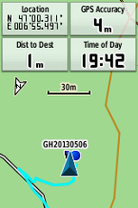
{{GalleryItem | File:2013-05-06_47_6-01-reached_709.png | reached! }} | {{GalleryItem | File:2013-05-06_47_6-01-reached_709.png | reached! }} | ||
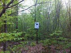
| − | {{GalleryItem | File:2013-05-06_47_6-03-crox_at_hash.jpg | [[user:Crox|me]] at the hash }} | + | {{GalleryItem | File:2013-05-06_47_6-03-crox_at_hash.jpg | [[user:Crox|me]] at the hash, with the [[user:Crox/Poster|poster]] in the background }} |
{{GalleryItem | File:2013-05-06_47_6-04-hash.jpg | how the place looked like }} | {{GalleryItem | File:2013-05-06_47_6-04-hash.jpg | how the place looked like }} | ||
}} | }} | ||
Revision as of 20:33, 6 May 2013
| Mon 6 May 2013 in 47,6: 47.0051680, 6.9249640 geohashing.info google osm bing/os kml crox |
Location
"Verger au Renard", near Route de Chaumont, Neuchâtel, Switzerland
Participants
Plans
Driving from Neuchâtel train station, ETA 19:50
Expedition
Went according to plan. Actually, as far as I remember this was the first time that I arrived before the ETA that I calculated during the planning phase...
Photos
|


