Difference between revisions of "2013-04-26 52 -0"
imported>Benjw (deploy expedition template) |
imported>Benjw (add expedition report) |
||
| Line 1: | Line 1: | ||
| − | + | [[Image:2013-04-26 52 -0 hashpoint.jpg|thumb|left]] | |
| − | |||
| − | |||
| − | [[Image: | ||
| − | |||
| − | |||
| − | |||
| − | |||
| − | |||
| − | |||
{{meetup graticule | {{meetup graticule | ||
| lat=52 | | lat=52 | ||
| lon=-0 | | lon=-0 | ||
| date=2013-04-26 | | date=2013-04-26 | ||
| + | | graticule_name=Cambridge, UK | ||
| + | | graticule_link=Cambridge, United Kingdom | ||
}} | }} | ||
| − | + | {{User:Benjw/multihash|2013-04-26 52 -0|2013-04-26 52 0}} | |
| − | |||
| − | |||
== Location == | == Location == | ||
| − | + | Right in the middle of the A1198 minor road, south of Papworth Everard. | |
== Participants == | == Participants == | ||
| − | + | * [[User:Benjw|Benjw]] | |
| − | |||
== Plans == | == Plans == | ||
| − | + | Today was a doubly lucky location, as due to the prime meridian, this hashpoint and its neighbour to the east, [[2013-04-26 52 0]], were only 14.6 km apart, as the crow flies. Ben resolved to make it to both hashpoints during the afternoon. On looking a bit closer, he also discovered that the [[2013-04-26 52 0|52,0]] hashpoint was on the A14 east-west trunk route, and the [[2013-04-26 52 -0|52,-0]] hashpoint was on the A1198 minor road, which joins the A428 at a roundabout just south of the hashpoint. The A428 then turns into the A14 as it approaches Cambridge. This meant that the hashes were a mere 15.8 km apart, and were separated almost entirely by a dual-carriageway with a speed limit of 70 mph (112 kph). This would be an excellent chance to set a new record for Ben's quickest double-hash, currently set at "under 20 minutes" with [[2012-09-25 52 0]] and [[2012-09-25 52 -0]]. | |
== Expedition == | == Expedition == | ||
| − | + | On the day itself, pretty much all went to plan. Ben started with this hashpoint as it meant that he would then be on the correct carriageway of the A14 for the [[2013-04-26 52 0|52,0]] hash, driving east to get there. He [[Speed racer achievement|speed-raced]] through the hashpoint at 16:21, then turned round, came back and parked on the grass verge so he could get out and take photos. The traffic made this a little difficult, as the hashpoint itself was in the middle of a road with a 60 mph speed limit, and photos from the actual point had to be taken in the gaps in the traffic. None, in fact, came out well, so plan B was to simply take them from the side of the road -- which was actually within the three-metre GPS tolerance anyway. | |
| − | + | After faffing around with the camera and alarming passing drivers for a good ten minutes, Ben stood at the hashpoint and reset the trip time function on his GPS to zero. After taking a photo to prove this, he jogged back to the car and set off for the [[2013-04-26 52 0|next hashpoint]]. | |
| − | |||
== Photos == | == Photos == | ||
| − | |||
| − | |||
| − | |||
<gallery perrow="5"> | <gallery perrow="5"> | ||
| + | Image:2013-04-26 52 -0 speed racer.jpg | Speed racing through the hashpoint. | ||
| + | Image:2013-04-26 52 -0 hashpoint.jpg | Here it is again, more slowly. | ||
| + | Image:2013-04-26 52 -0 proof.jpg | Proof of hash. | ||
| + | Image:2013-04-26 52 -0 happy hasher.jpg | One happy hasher! | ||
| + | Image:2013-04-26 52 -0 stopwatch.jpg | The stopwatch was started... | ||
</gallery> | </gallery> | ||
| − | == | + | == Shiny ribbons earned == |
{{#vardefine:ribbonwidth|800px}} | {{#vardefine:ribbonwidth|800px}} | ||
| − | + | {{land geohash | |
| − | + | | latitude = 52 | |
| − | + | | longitude = -0 | |
| − | + | | date = 2013-04-26 | |
| − | + | | name = [[User:Benjw|Benjw]] | |
| − | [[ | + | | image = 2013-04-26 52 -0 hashpoint.jpg |
| − | + | }} | |
| − | + | {{Speed racer | |
| − | + | | latitude = 52 | |
| − | [[ | + | | longitude = -0 |
| − | -- | + | | date = 2013-04-26 |
| + | | name = [[User:Benjw|Benjw]] | ||
| + | | image = 2013-04-26 52 -0 speed racer.jpg | ||
| + | | speed = more-or-less 60 mph | ||
| + | }} | ||
| − | |||
[[Category:Expeditions]] | [[Category:Expeditions]] | ||
| − | |||
[[Category:Expeditions with photos]] | [[Category:Expeditions with photos]] | ||
| − | |||
| − | |||
| − | |||
| − | |||
| − | |||
[[Category:Coordinates reached]] | [[Category:Coordinates reached]] | ||
| − | |||
| − | |||
| − | |||
| − | |||
| − | |||
| − | |||
| − | |||
| − | |||
| − | |||
| − | |||
| − | |||
| − | |||
| − | |||
| − | |||
| − | |||
| − | |||
| − | |||
| − | |||
Revision as of 13:57, 17 June 2013

| Fri 26 Apr 2013 in Cambridge, UK: 52.2348081, -0.1075013 geohashing.info google osm bing/os kml crox |
| This expedition was part of a multihash by Benjw. For the other parts, see: | |||||
|---|---|---|---|---|---|
| 2013-04-26 52 -0 | 2013-04-26 52 0 | ||||
Location
Right in the middle of the A1198 minor road, south of Papworth Everard.
Participants
Plans
Today was a doubly lucky location, as due to the prime meridian, this hashpoint and its neighbour to the east, 2013-04-26 52 0, were only 14.6 km apart, as the crow flies. Ben resolved to make it to both hashpoints during the afternoon. On looking a bit closer, he also discovered that the 52,0 hashpoint was on the A14 east-west trunk route, and the 52,-0 hashpoint was on the A1198 minor road, which joins the A428 at a roundabout just south of the hashpoint. The A428 then turns into the A14 as it approaches Cambridge. This meant that the hashes were a mere 15.8 km apart, and were separated almost entirely by a dual-carriageway with a speed limit of 70 mph (112 kph). This would be an excellent chance to set a new record for Ben's quickest double-hash, currently set at "under 20 minutes" with 2012-09-25 52 0 and 2012-09-25 52 -0.
Expedition
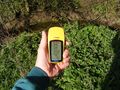
On the day itself, pretty much all went to plan. Ben started with this hashpoint as it meant that he would then be on the correct carriageway of the A14 for the 52,0 hash, driving east to get there. He speed-raced through the hashpoint at 16:21, then turned round, came back and parked on the grass verge so he could get out and take photos. The traffic made this a little difficult, as the hashpoint itself was in the middle of a road with a 60 mph speed limit, and photos from the actual point had to be taken in the gaps in the traffic. None, in fact, came out well, so plan B was to simply take them from the side of the road -- which was actually within the three-metre GPS tolerance anyway.
After faffing around with the camera and alarming passing drivers for a good ten minutes, Ben stood at the hashpoint and reset the trip time function on his GPS to zero. After taking a photo to prove this, he jogged back to the car and set off for the next hashpoint.
Photos
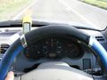
Speed racing through the hashpoint.
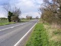
Here it is again, more slowly.
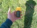
Proof of hash.
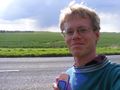
One happy hasher!
The stopwatch was started...


Shiny ribbons earned
Benjw earned the Land geohash achievement
|
Benjw earned the Speed racer achievement
|