Difference between revisions of "2013-08-06 48 -115"
imported>Michael5000 m (→Photos) |
imported>Michael5000 m (→Achievements) |
||
| Line 48: | Line 48: | ||
== Achievements == | == Achievements == | ||
{{#vardefine:ribbonwidth|800px}} | {{#vardefine:ribbonwidth|800px}} | ||
| − | + | {{consecutive geohash 2 | |
| + | | count = 4 | ||
| + | | latitude = 45 | ||
| + | | longitude = -121 | ||
| + | | date = 2013-08-03 | ||
| + | | name = [[User:Michael5000|Michael5000]] | ||
| + | |||
| + | }} | ||
| − | |||
| − | |||
| − | |||
| − | |||
| − | |||
| − | |||
| − | |||
| − | + | [[Category:New report]] | |
[[Category:Expeditions]] | [[Category:Expeditions]] | ||
| − | |||
[[Category:Expeditions with photos]] | [[Category:Expeditions with photos]] | ||
| − | |||
| − | |||
| − | |||
| − | |||
| − | |||
[[Category:Coordinates reached]] | [[Category:Coordinates reached]] | ||
| − | |||
| − | |||
| − | |||
| − | |||
| − | |||
| − | |||
| − | |||
| − | |||
| − | |||
| − | |||
| − | |||
| − | |||
| − | |||
| − | |||
| − | |||
| − | |||
| − | |||
| − | |||
Revision as of 05:20, 7 August 2013
| Tue 6 Aug 2013 in 48,-115: 48.5464265, -115.9772960 geohashing.info google osm bing/os kml crox |
Location
In the forest northwest of Troy, Montana.
Participants
Plans
Several miles up a forest road and on the wall of a canyon, this one didn't really look all that promising. But it was the best shot available on my route for the day (Great Falls to Bonners Ferry, so I decided to give it a go.
Expedition
It worked out fine! NF-4402 deteriorated a little after the first half mile, but remained very useable to within .20 miles of the hashpoint. After that there was a lot of climbing through thick forest. I stopped a few times to ask myself if I was getting myself into danger, but was able to answer: nope! Rather than worry too much about a beeline to the hashpoint, I took whatever relatively clear stretch of forest would take me up to the right elevation, and then followed the contour to the point. Then I climbed back down, dusted myself off, and went along my merry way.
Tracklog
Photos
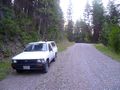
The Expedition Vehicle .20 miles from the hashpoint.
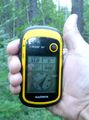
Boring picture of GPS gadget.

Perspiring like an ox after a stiff climb.
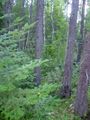
Looking from the hashpoint in one direction...
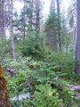
...and in the other.


Achievements
Michael5000 earned the Consecutive geohash achievement
|