Difference between revisions of "2014-03-06 52 1"
imported>Sourcerer m ([live picture] [http://www.openstreetmap.org/?lat=52.81532406806946&lon=1.3810962438583374&zoom=16&layers=B000FTF @52.8153,1.3811]) |
imported>Sourcerer (→Sourcerer New Expedition) |
||
| Line 1: | Line 1: | ||
| − | |||
| − | |||
| − | |||
| − | |||
| − | |||
| − | |||
| − | |||
| − | |||
| − | |||
| − | |||
{{meetup graticule | {{meetup graticule | ||
| lat=52 | | lat=52 | ||
| lon=1 | | lon=1 | ||
| date=2014-03-06 | | date=2014-03-06 | ||
| + | | graticule_name=Norwich | ||
| + | | graticule_link=Norwich, United Kingdom | ||
}} | }} | ||
| − | |||
| − | |||
== Location == | == Location == | ||
| − | + | ||
| + | A roadside hashpoint close to North Walsham railway station, Norfolk, UK. | ||
== Participants == | == Participants == | ||
| − | |||
| − | |||
| − | + | [[User:Sourcerer|Sourcerer]] | |
| − | |||
== Expedition == | == Expedition == | ||
| − | |||
| + | *Arrived. -- [[User:Sourcerer|Sourcerer]] ([[User talk:Sourcerer|talk]]) [http://www.openstreetmap.org/?lat=52.81532943248749&lon=1.3810855150222778&zoom=16&layers=B000FTF @52.8153,1.3811] 20:00, 06 March 2014 (GMT) | ||
| + | |||
| + | A detour after work lead to this hashpoint. It was a clear night with a waxing moon and driving conditions were good. Sadly this did not prevent a small deer from walking straight into my path. There was no time to brake and the poor creature got hit at 80 km/h. It was a perfect head on collision so there would have been no suffering. On a previous expedition I awarded myself the gratuitous "Bambihash" for deer spotting so today, with regret, I get the Bambimash. | ||
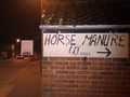
| − | + | The hashpoint was in the front yard of a house in North Walsham. There was a convenient wall to balance the GPSR for the evidence photo. The manure photo is also clearly visible on Google street view. Manure hashes are an amusing feature of rural geohashing. | |
| − | |||
| − | |||
== Photos == | == Photos == | ||
| − | |||
| − | |||
| − | |||
<gallery perrow="5"> | <gallery perrow="5"> | ||
| − | |||
Image:2014-03-06_52_1_20-02-25-707.jpg | [http://www.openstreetmap.org/?lat=52.81532406806946&lon=1.3810962438583374&zoom=16&layers=B000FTF @52.8153,1.3811] | Image:2014-03-06_52_1_20-02-25-707.jpg | [http://www.openstreetmap.org/?lat=52.81532406806946&lon=1.3810962438583374&zoom=16&layers=B000FTF @52.8153,1.3811] | ||
| + | Image:2014-03-06 52 1 Sourcerer 1.jpg | The Hashpoint | ||
</gallery> | </gallery> | ||
== Achievements == | == Achievements == | ||
| − | |||
| − | |||
| + | {{gratuitous ribbon | ||
| + | | latitude = 52 | ||
| + | | longitude = 1 | ||
| + | | date = 2014-03-06 | ||
| + | | achievement = Bambimash | ||
| + | | description = failing to avoid a red deer while driving at 80 km/h. | ||
| + | | name = Sourcerer | ||
| + | }} | ||
| − | + | == Other geohashing expeditions on the same day == | |
| − | |||
| − | |||
| − | |||
| − | |||
| − | + | {{expedition summaries|2014-03-06}} | |
| − | |||
| − | |||
| − | |||
| − | |||
[[Category:Expeditions]] | [[Category:Expeditions]] | ||
| − | |||
[[Category:Expeditions with photos]] | [[Category:Expeditions with photos]] | ||
| − | |||
| − | |||
| − | |||
| − | |||
| − | |||
[[Category:Coordinates reached]] | [[Category:Coordinates reached]] | ||
| − | |||
| − | |||
| − | |||
| − | |||
| − | |||
| − | |||
| − | |||
| − | |||
| − | |||
| − | |||
| − | |||
| − | |||
| − | |||
| − | |||
| − | |||
| − | |||
| − | |||
| − | |||
Revision as of 07:52, 7 March 2014
| Thu 6 Mar 2014 in Norwich: 52.8153834, 1.3810186 geohashing.info google osm bing/os kml crox |
Contents
Location
A roadside hashpoint close to North Walsham railway station, Norfolk, UK.
Participants
Expedition
- Arrived. -- Sourcerer (talk) @52.8153,1.3811 20:00, 06 March 2014 (GMT)
A detour after work lead to this hashpoint. It was a clear night with a waxing moon and driving conditions were good. Sadly this did not prevent a small deer from walking straight into my path. There was no time to brake and the poor creature got hit at 80 km/h. It was a perfect head on collision so there would have been no suffering. On a previous expedition I awarded myself the gratuitous "Bambihash" for deer spotting so today, with regret, I get the Bambimash.
The hashpoint was in the front yard of a house in North Walsham. There was a convenient wall to balance the GPSR for the evidence photo. The manure photo is also clearly visible on Google street view. Manure hashes are an amusing feature of rural geohashing.
Photos
The Hashpoint


Achievements
Sourcerer earned the Bambimash
|
Other geohashing expeditions on the same day
Expeditions and Plans
| 2014-03-06 | ||
|---|---|---|
| Des Moines, Iowa | Chair | located on West 1st Street in Grimes. |
| The Dalles, Oregon | kydlt | Outside Cascade Locks, OR |
| Paris, France | Dunaril, Katu | On a sidewalk, along a college in the center of Ivry-sur-Seine, Val-de-Marn... |
| Most, Czech Republic | Danatar | in a meadow near Helbigsdorf, a part of Mulda. Country: Germany; state: Sa... |
| Norwich, United Kingdom | Sourcerer | A roadside hashpoint close to North Walsham railway station, Norfolk, UK. |