Difference between revisions of "2014-07-26 47 -0"
From Geohashing
imported>JwB m |
imported>JwB m |
||
| Line 36: | Line 36: | ||
Image:2014-07-26 47 -0 screen.png | as close as we got | Image:2014-07-26 47 -0 screen.png | as close as we got | ||
Image:2014-07-26 47 -0 corn.jpg | just 100m through the corn | Image:2014-07-26 47 -0 corn.jpg | just 100m through the corn | ||
| + | </gallery> | ||
== Achievements == | == Achievements == | ||
Revision as of 09:10, 10 August 2014
| Sat 26 Jul 2014 in 47,-0: 47.7434847, -0.3978304 geohashing.info google osm bing/os kml crox |
Location
a field near Morannes
Participants
Plans
for the start of our holidays, we stayed 4 days in a B&B in the Sarthe valley. On our way to Brittany, I found that this hash was only ~5 km from the B&B, so we might as well visit it.
Expedition
Easy drive up there. Then found out that it was in a corn field, and that the corn was high. Going in would be trampling crop, so at 100m from the point the trail stopped. With reference to 2014-07-25_34_-101 I could claim victory.
Photos
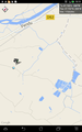
as close as we got
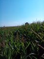
just 100m through the corn

