Difference between revisions of "2015-11-28 52 1"
imported>Sourcerer m ([live picture] Proof. [http://www.openstreetmap.org/?lat=52.54820287&lon=1.06208503&zoom=16&layers=B000FTF @52.5482,1.0621]) |
imported>Sourcerer m (→New expedition) |
||
| Line 20: | Line 20: | ||
== Expedition == | == Expedition == | ||
| + | *Arrived -- [[User:Sourcerer|Sourcerer]] ([[User talk:Sourcerer|talk]]) [http://www.openstreetmap.org/?lat=52.54818678&lon=1.06209040&zoom=16&layers=B000FTF @52.5482,1.0621] 00:00, 28 November 2015 (GMT) | ||
| + | For parking, there was a large concrete area for agricultural vehicles. Tractor tracks led in the right direction through winter wheat. A short right angle at the end, led to the zero point. I got the evidence photo four minutes early and waited for midnight for my arrival message. The wind had dropped and there was moon light. The wet and windy weather front passed through quickly. The lights of the school could be seen in the distance. | ||
| − | |||
| − | |||
== Photos == | == Photos == | ||
<gallery> | <gallery> | ||
| − | |||
Image:2015-11-28_52_1_Sourcerer_1448668602853.jpg | Proof. [http://www.openstreetmap.org/?lat=52.54820287&lon=1.06208503&zoom=16&layers=B000FTF @52.5482,1.0621] | Image:2015-11-28_52_1_Sourcerer_1448668602853.jpg | Proof. [http://www.openstreetmap.org/?lat=52.54820287&lon=1.06208503&zoom=16&layers=B000FTF @52.5482,1.0621] | ||
| + | Image:2015-11-28_52_1_Sourcerer.jpg | Google Earth Track | ||
</gallery> | </gallery> | ||
| Line 40: | Line 40: | ||
}} | }} | ||
| − | |||
| − | |||
[[Category:Expeditions]] | [[Category:Expeditions]] | ||
[[Category:Expeditions with photos]] | [[Category:Expeditions with photos]] | ||
[[Category:Coordinates reached]] | [[Category:Coordinates reached]] | ||
| − | |||
Revision as of 01:29, 28 November 2015
| Sat 28 Nov 2015 in 52,1: 52.5481804, 1.0620925 geohashing.info google osm bing/os kml crox |
Location
In a field north of Wymondham College, Norfolk, UK.
Participants
Plans
Expedition two of two spanning midnight - 2015-11-27 52 0 - 2015-11-28 52 1 - ETA 00:00.
Expedition
- Arrived -- Sourcerer (talk) @52.5482,1.0621 00:00, 28 November 2015 (GMT)
For parking, there was a large concrete area for agricultural vehicles. Tractor tracks led in the right direction through winter wheat. A short right angle at the end, led to the zero point. I got the evidence photo four minutes early and waited for midnight for my arrival message. The wind had dropped and there was moon light. The wet and windy weather front passed through quickly. The lights of the school could be seen in the distance.
Photos
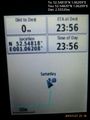
Proof. @52.5482,1.0621
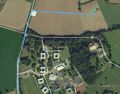
Google Earth Track


Achievements
Expeditions and Plans
| 2015-11-28 | ||
|---|---|---|
| Dunkirk, New York | Pedalpusher | In the grass by the corner of Woodchuck Rd, on the edge of Seneca Nation Te... |
| McMinnville, Oregon | Jim | A field near Verboort, south of Hwy 26 |
| Stuttgart, Germany | Klaus | in the forest behind Waldhäuser-Ost, Tübingen |
| Norwich, United Kingdom | Sourcerer | In a field north of Wymondham College, Norfolk, UK. |
Sourcerer's Expedition Links
2015-11-27 52 0 - 2015-11-28 52 1 - 2015-11-29 52 1 - KML file download of Sourcerer's expeditions for use with Google Earth.