Difference between revisions of "2017-03-16 48 11"
imported>Solli |
imported>Solli |
||
| Line 1: | Line 1: | ||
| − | |||
| − | |||
| − | |||
| − | |||
| − | |||
| − | |||
| − | |||
| − | |||
| − | |||
| − | |||
{{meetup graticule | {{meetup graticule | ||
| lat=48 | | lat=48 | ||
| Line 15: | Line 5: | ||
}} | }} | ||
| − | |||
__NOTOC__ | __NOTOC__ | ||
| Line 22: | Line 11: | ||
== Participants == | == Participants == | ||
| − | * [[ | + | * [[User:Solli|Solli]] |
== Plans == | == Plans == | ||
| Line 28: | Line 17: | ||
== Expedition == | == Expedition == | ||
| − | + | What an utterly stupid hobby! I spent my lunch break driving 75 km in total just to get to a random point. Why? Because I can. I took the small road next to the highway to Allershausen, passing the hashpoint within 150 meters. Then I went on the A9 and sped to the south, driving over the hash location. | |
| − | == | + | Since I was alone and I did not want to play around with my phone or a camara while driving I used the app "GPS Speedo" for the proof. This app simply displays location and speed. I took a screen record while passing the point and afterwards extracted the appropiate still from the movie. |
| − | + | ||
| + | === Speed Racer === | ||
| + | I was hoping to earn the speed racer ribbon during this expedition. As you might know there is no general speed limit on German "Autobahnen", but at this location there usually is one set by the Verkehrsleitsystem (traffic control system). However when I went there there was no restriction - just a few hundred metres behind the hash point maximum speed was 120 km/h. There was even a radar speed check on the next bridge, I hope they didn't get me. If they did I can at least claim a police geohash. :-/ | ||
== Photos == | == Photos == | ||
| − | |||
| − | |||
| − | |||
<gallery perrow="5"> | <gallery perrow="5"> | ||
| + | Image:2017-03-16 48 11 Solli 01.png | The nearest point on the little road next to the Autobahn | ||
| + | Image:2017-03-16 48 11 Solli 02.jpg | The hashpoint on the A9 | ||
| + | Image:2017-03-16 48 11 Solli 03.png | Screenshot while speeding over the location | ||
</gallery> | </gallery> | ||
== Achievements == | == Achievements == | ||
{{#vardefine:ribbonwidth|800px}} | {{#vardefine:ribbonwidth|800px}} | ||
| − | + | {{Radio Yerevan | |
| + | | achievement = [[Speed racer achievement]] | ||
| + | | detail = there was no speed limit on that German Autobahn and therefore no maximum speed. | ||
| + | | latitude = 48 | ||
| + | | longitude = 11 | ||
| + | | date = 2017-03-16 | ||
| + | | user = [[User:Solli|Solli]] | ||
| + | }} | ||
| − | + | {{land geohash | |
| − | + | | latitude = 48 | |
| − | + | | longitude = 11 | |
| − | + | | date = 2017-03-16 | |
| − | + | | name = Solli | |
| − | + | }} | |
| − | |||
| − | |||
| − | |||
| − | |||
| − | |||
| − | |||
| − | |||
[[Category:Expeditions]] | [[Category:Expeditions]] | ||
| − | |||
[[Category:Expeditions with photos]] | [[Category:Expeditions with photos]] | ||
| − | |||
| − | |||
| − | |||
| − | |||
| − | |||
[[Category:Coordinates reached]] | [[Category:Coordinates reached]] | ||
| − | |||
| − | |||
| − | |||
| − | |||
| − | |||
| − | |||
| − | |||
| − | |||
| − | |||
| − | |||
| − | |||
| − | |||
| − | |||
| − | |||
| − | |||
| − | |||
| − | |||
| − | |||
Revision as of 12:56, 16 March 2017
| Thu 16 Mar 2017 in 48,11: 48.3685911, 11.5953261 geohashing.info google osm bing/os kml crox |
Location
On the Highway A9 between Allershausen and Kreuz Neufahrn in southern direction
Participants
Plans
Solli plans to go there around lunch time. Find an app that displays location and speed, make a screen video and drive from Allershausen to the south.
Expedition
What an utterly stupid hobby! I spent my lunch break driving 75 km in total just to get to a random point. Why? Because I can. I took the small road next to the highway to Allershausen, passing the hashpoint within 150 meters. Then I went on the A9 and sped to the south, driving over the hash location.
Since I was alone and I did not want to play around with my phone or a camara while driving I used the app "GPS Speedo" for the proof. This app simply displays location and speed. I took a screen record while passing the point and afterwards extracted the appropiate still from the movie.
Speed Racer
I was hoping to earn the speed racer ribbon during this expedition. As you might know there is no general speed limit on German "Autobahnen", but at this location there usually is one set by the Verkehrsleitsystem (traffic control system). However when I went there there was no restriction - just a few hundred metres behind the hash point maximum speed was 120 km/h. There was even a radar speed check on the next bridge, I hope they didn't get me. If they did I can at least claim a police geohash. :-/
Photos
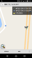
The nearest point on the little road next to the Autobahn

The hashpoint on the A9
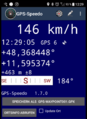
Screenshot while speeding over the location


Achievements
Is it true that Solli earned the Speed racer achievement?
|
Solli earned the Land geohash achievement
|