Difference between revisions of "2017-09-04 48 11"
From Geohashing
imported>Solli m (typo) |
imported>Solli |
||
| Line 20: | Line 20: | ||
== Photos == | == Photos == | ||
| − | |||
| − | |||
| − | |||
<gallery perrow="5"> | <gallery perrow="5"> | ||
| + | Image:2017-09-04 48 11 Solli 01.png | Proof | ||
| + | Image:2017-09-04 48 11 Solli 02.jpg | View from the hashpoint | ||
| + | Image:2017-09-04 48 11 Solli 03.jpg | Stupid Grin (tm) | ||
</gallery> | </gallery> | ||
== Achievements == | == Achievements == | ||
{{#vardefine:ribbonwidth|800px}} | {{#vardefine:ribbonwidth|800px}} | ||
| − | + | {{land geohash | |
| + | | latitude = 48 | ||
| + | | longitude = 11 | ||
| + | | date = 2017-09-04 | ||
| + | | name = Solli | ||
| + | }} | ||
| − | + | {{Two to the N achievement | |
| − | + | | count = 4 | |
| − | + | | date = 2017-09-04 | |
| + | | latitude = 48 | ||
| + | | longitude = 11 | ||
| + | | name = Solli | ||
| + | | reached = true | ||
| + | | graticule = false | ||
| + | }} | ||
| − | |||
| − | |||
| − | |||
| − | |||
| − | |||
| − | |||
| − | |||
| − | |||
| − | |||
| − | |||
[[Category:Expeditions]] | [[Category:Expeditions]] | ||
| − | |||
[[Category:Expeditions with photos]] | [[Category:Expeditions with photos]] | ||
| − | |||
| − | |||
| − | |||
| − | |||
| − | |||
[[Category:Coordinates reached]] | [[Category:Coordinates reached]] | ||
| − | |||
| − | |||
| − | |||
| − | |||
| − | |||
| − | |||
| − | |||
| − | |||
| − | |||
| − | |||
| − | |||
| − | |||
| − | |||
| − | |||
| − | |||
| − | |||
| − | |||
| − | |||
Revision as of 07:20, 5 September 2017
| Mon 4 Sep 2017 in 48,11: 48.1937160, 11.7363380 geohashing.info google osm bing/os kml crox |
Location
On a field near Aschheim, south of the Speichersee
Participants
Plans
Just 3 km from home! The plan was to go there after work.
Expedition
I drove from Kirchheim to the Abfanggraben and walked ~1km to the hashpoint. It was on a harvested field, so no crops were destroyed. It was a nice walk on a sunny evening and quite an easy expedition.
Photos
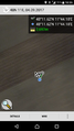
Proof
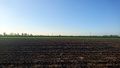
View from the hashpoint
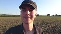
Stupid Grin (tm)


Achievements
Solli earned the Land geohash achievement
|
Solli earned the Two to the N achievement
|