Difference between revisions of "2019-04-20 52 9"
imported>GeorgDerReisende (new report) |
imported>GeorgDerReisende (expedition report for Hannover-Linden-Süd) |
||
| Line 1: | Line 1: | ||
| + | [[Image:{{{image|2019-04-20 52 9 GeorgDerReisende 0001.jpg}}}|thumb|left]] | ||
| − | |||
| − | |||
| − | |||
| − | |||
| − | |||
| − | |||
| − | |||
| − | |||
| − | |||
{{meetup graticule | {{meetup graticule | ||
| lat=52 | | lat=52 | ||
| Line 19: | Line 11: | ||
== Location == | == Location == | ||
| − | + | ||
| + | The hash lay between the houses Göttinger Straße 44 and Strousbergstraße 2 in Hannover. | ||
== Participants == | == Participants == | ||
| − | + | ||
| − | + | [[User:GeorgDerReisende|GeorgDerReisende]] | |
== Plans == | == Plans == | ||
| − | + | ||
| + | Wanted to be there at hash o'clock. | ||
== Expedition == | == Expedition == | ||
| − | |||
| − | + | I left home at 9:30 and with a bus, two trains and a tram I arrived near the hash. I walked around and at hash o'clock I arrived at the hash. Because I don't have my GPS I looked onto the map and the areal view and couldn't see the exact location. On the southern side of the houses I found a patch with flowers and I walked along it. But I asked, if I was near enough and I tried to look to the other side of the wall with the hollow chequer bricks and I could stand at both edges of the houses. And with the five meters radius at both points I thought I was there. Then I waited some minutes until hash o'clock, but I couldn't wait for long, because I wanted to get an early train home. | |
| − | |||
== Photos == | == Photos == | ||
| − | |||
| − | |||
| − | |||
<gallery perrow="5"> | <gallery perrow="5"> | ||
| + | 2019-04-20 52 9 GeorgDerReisende 5625.jpg | first view to the hash | ||
| + | 2019-04-20 52 9 GeorgDerReisende 5626.jpg | nearer view | ||
| + | 2019-04-20 52 9 GeorgDerReisende 5629.jpg | detailed view | ||
| + | 2019-04-20 52 9 GeorgDerReisende 5631.jpg | view from the south | ||
| + | 2019-04-20 52 9 GeorgDerReisende 5632.jpg | view from the north | ||
| + | 2019-04-20 52 9 GeorgDerReisende 5633.jpg | standing at the edge of Göttinger Straße 44 | ||
| + | 2019-04-20 52 9 GeorgDerReisende 5634.jpg | standing at the edge of Strousbergstraße 2 | ||
| + | 2019-04-20 52 9 GeorgDerReisende 5635.jpg | view to the east | ||
| + | 2019-04-20 52 9 GeorgDerReisende 5636.jpg | view to the north | ||
| + | 2019-04-20 52 9 GeorgDerReisende 5639.jpg | the geohasher | ||
| + | 2019-04-20 52 9 GeorgDerReisende 5640.jpg | view to the south | ||
| + | 2019-04-20 52 9 GeorgDerReisende 5641.jpg | view to the west | ||
| + | 2019-04-20 52 9 GeorgDerReisende 5627.jpg | the Göttinger Straße to the south | ||
| + | 2019-04-20 52 9 GeorgDerReisende 5628.jpg | the Göttinger Straße to the north | ||
</gallery> | </gallery> | ||
| Line 45: | Line 48: | ||
<!-- Add any achievement ribbons you earned below, or remove this section --> | <!-- Add any achievement ribbons you earned below, or remove this section --> | ||
| − | + | {{XKCD Centurion | count = 52 | name = GeorgDerReisende }} | |
| − | + | {{xkcd-100 | latitude = 52 | longitude = 9 | date = 2019-04-20 | distance = 120 miles | name = GeorgDerReisende | image = 2019-04-20 52 9 GeorgDerReisende 0001.jpg }} | |
| − | |||
| − | + | [[Category:Expeditions]] | |
| − | + | [[Category:Expeditions with photos]] | |
| − | |||
| − | [[Category: | ||
| − | |||
| − | |||
| − | |||
| − | |||
| − | |||
| − | |||
| − | |||
| − | |||
[[Category:Expedition without GPS]] | [[Category:Expedition without GPS]] | ||
| − | |||
| − | |||
| − | |||
| − | |||
| − | |||
| − | |||
| + | {{location|DE|NI|H}} | ||
| − | + | [[Category:Coordinates reached]] | |
| − | [[Category:Coordinates | ||
| − | |||
| − | |||
| − | |||
| − | |||
| − | |||
| − | |||
| − | |||
| − | |||
| − | |||
| − | |||
| − | |||
| − | |||
| − | |||
| − | |||
Latest revision as of 23:00, 20 April 2019

| Sat 20 Apr 2019 in 52,9: 52.3563767, 9.7175604 geohashing.info google osm bing/os kml crox |
Location
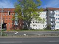
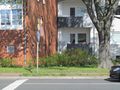
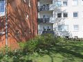
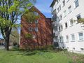
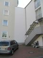
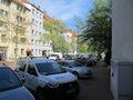
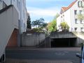
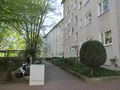
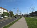
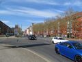
The hash lay between the houses Göttinger Straße 44 and Strousbergstraße 2 in Hannover.
Participants
Plans
Wanted to be there at hash o'clock.
Expedition
I left home at 9:30 and with a bus, two trains and a tram I arrived near the hash. I walked around and at hash o'clock I arrived at the hash. Because I don't have my GPS I looked onto the map and the areal view and couldn't see the exact location. On the southern side of the houses I found a patch with flowers and I walked along it. But I asked, if I was near enough and I tried to look to the other side of the wall with the hollow chequer bricks and I could stand at both edges of the houses. And with the five meters radius at both points I thought I was there. Then I waited some minutes until hash o'clock, but I couldn't wait for long, because I wanted to get an early train home.
Photos
first view to the hash
nearer view
detailed view
view from the south
view from the north
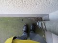
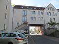
standing at the edge of Göttinger Straße 44
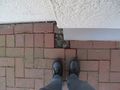
standing at the edge of Strousbergstraße 2
view to the east
view to the north
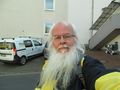
the geohasher
view to the south
view to the west
the Göttinger Straße to the south
the Göttinger Straße to the north


Achievements
GeorgDerReisende earned the xkcd Quinquaginturion achievement
|
GeorgDerReisende earned the XKCD-100 Achievement
|