Difference between revisions of "2020-08-17 48 7"
From Geohashing
m (Location) |
|||
| Line 15: | Line 15: | ||
== Photos == | == Photos == | ||
<gallery perrow="5"> | <gallery perrow="5"> | ||
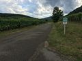
| + | Image:2020-08-17 48 7 01.jpg | On the road from Riquewihr | ||
| + | Image:2020-08-17 48 7 02.jpg | Passing in Kientzheim | ||
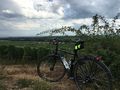
| + | Image:2020-08-17 48 7 03.jpg | A few meters above the geohash | ||
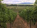
| + | Image:2020-08-17 48 7 04.jpg | Strolling in the vineyard | ||
| + | Image:2020-08-17 48 7 05.png | Coordinates reached | ||
| + | Image:2020-08-17 48 7 06.jpg | Stupid grin | ||
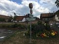
| + | Image:2020-08-17 48 7 07.jpg | Sigolsheim | ||
| + | Image:2020-08-17 48 7 08.jpg | That would look nice on a postcard | ||
</gallery> | </gallery> | ||
| Line 43: | Line 51: | ||
[[Category:Expeditions]] | [[Category:Expeditions]] | ||
| + | [[Category:Expeditions with photos]] | ||
[[Category:Coordinates reached]] | [[Category:Coordinates reached]] | ||
{{location|FR|68}} | {{location|FR|68}} | ||
Revision as of 08:06, 20 August 2020
| Mon 17 Aug 2020 in 48,7: 48.1359797, 7.3102063 geohashing.info google osm bing/os kml crox |
Location
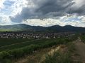
In a vineyard above Sigolsheim.
Participants
Expedition
Photos
On the road from Riquewihr
Passing in Kientzheim
A few meters above the geohash
Strolling in the vineyard
Coordinates reached

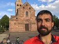
Stupid grin
Sigolsheim
That would look nice on a postcard


Achievements
Baarde earned the Land geohash achievement
|
Baarde earned the Bicycle geohash achievement
|
Baarde earned the Two to the N achievement
|