Difference between revisions of "2019-08-03 45 -119"
imported>Michael5000 m (→Achievements) |
Michael5000 (talk | contribs) (→Photos) |
||
| Line 25: | Line 25: | ||
<gallery perrow="5"> | <gallery perrow="5"> | ||
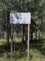
File:2019-08-03 45 -119 sign.jpg|This was the sign at my turnoff. | File:2019-08-03 45 -119 sign.jpg|This was the sign at my turnoff. | ||
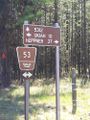
| − | File:2019-08-03 45 -119 sign 2.jpg|This was the sign across the road, which | + | File:2019-08-03 45 -119 sign 2.jpg|This was the sign across the road, which doesn't face into the sun. |
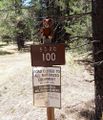
File:2019-08-03 45 -119 bear.jpg|This is far as we took the motorized vehicle. | File:2019-08-03 45 -119 bear.jpg|This is far as we took the motorized vehicle. | ||
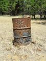
File:2019-08-03 45 -119 barrel.jpg|The hashbarrel. | File:2019-08-03 45 -119 barrel.jpg|The hashbarrel. | ||
Revision as of 23:00, 28 November 2021

| Sat 3 Aug 2019 in 45,-119: 45.1760465, -119.1228009 geohashing.info google osm bing/os kml crox |
Location
In National Forest land, not far off the road from Ukiah to Heppner.
Participants
- Michael5000: Expedition #222
Expedition
So, from 2019-08-03 45 -118 I wound my way out of the woods, back through LaGrande, and then up the highway to Ukiah, where my family lived for a memorably challenging year before I was born that they are still talking about. A well-maintained, paved, striped forest road goes through the Blue Mountains from Ukiah to Heppner, so getting to this hashpoint required no more than parking off of a side road and walking across a meadow. The shot-up barrel was around 100 feet from the hashpoint. I took my pictures, then continued on to Heppner, and from there pointed the prow back towards Portland and home. In The Dalles, I finally caught up with those enchiladas.
Photos
This was the sign at my turnoff.
This was the sign across the road, which doesn't face into the sun.
This is far as we took the motorized vehicle.
The hashbarrel.
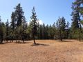
The meadow as viewed from the hashpoint.
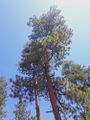
Looking up from the hashpoint


Achievements
Michael5000 earned the Multihash Achievement
|